Blog Archives

The Sands of Time and Change
Some 50,000 to 70,000 years ago, a giant lobe of the continental glacier that stretched across North America during the last ice age ground to a halt during what is known as the Wisconsin Stage, the most recent phase of the last global glaciation. For thousands of years, that small piece of the vast expanse of ice stayed relatively stagnant at its location, neither advancing nor retreating remarkably. Though the terminus of the glacier remained more or less in place, the ice itself continually moved, acting like a giant conveyor belt carrying a load of rocks and sediment scraped from the bedrock of continental North America. Year after year the glacier persisted, bringing layer upon layer of sediment with it. About 12,000 years ago, the planet began to warm dramatically; it was the end of the last ice age. The glacial lobe, melting in the rising global temperatures, retreated north to the arctic where snow persists year round. In its wake was left evidence of the glacier’s presence; on the expansive coastal plain just off the mainland of modern-day Massachusetts was a very conspicuous mound of sediment. That pile of debris, known as a terminal glacial moraine, was the genesis of Cape Cod.
At its start, Cape Cod was little more remarkable than a hilly mound of debris pocked with depressions rising above a broad plain, for off the coast of New England the continental shelf is wide and gradually slopes down to the sea. At the end of the last ice age, with much of the world’s water being locked up in the melting glaciers, the ocean water was much lower than it is presently. For thousands of years after the glacier’s retreat, Cape Cod as we know it was not surrounded by water; it was surrounded by land. Gradually, as the Atlantic began to rise from glacial meltwater, the mound of sand and rocks finally became a peninsula about 3,500 years ago; a very primitive Cape Cod could now be identified by its shoreline. But it was not yet the Cape Cod we know today. It would still take thousands of years more to mold the landscape into its present form.
But even the Cape Cod of today was not the Cape Cod of yesterday, and will not be the Cape Cod of tomorrow. Geologic forces act with gusto on this geologic infant. All around the coast of the Cape is a blanket of sand—the telltale sign of active erosion. Sand moves quite readily in the wind and waves; there is nothing quite so solid about the Cape, no feature quite so permanent. Though formed of sand and rock, the Cape is little more than a giant sand castle in the midst of an angry Atlantic. To find a solid foundation—bedrock—one must burrow hundreds to thousands of feet down. With no solid foundation, the Cape exists in a state of flux. Just twelve thousand years after its creation, the Cape is dramatically different than the day the glaciers retreated. Cape Cod has never found its state of geological stasis.

Conspicuously ringed by a rim of white, the sandy erodible shores of Cape Cod are visible even from space.
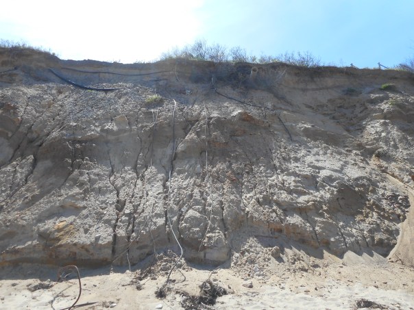
Incessantly, wind and water work their relentless magic on the Cape, continually transforming the landscape. Though everywhere on the Cape has potential for rapid erosion, nowhere is this process more apparent than on the Eastern seaboard. Unprotected from the vast fury of the Atlantic, the eastern shore faces the brunt of its unmitigated ocean waves. The force of winds and waves cumulatively wash away the beaches lining the shore, which undermines the land above from the base. As more beach disappears into the water, land from above will tumble down to replenish the beach sands. Thousands of years of water undercutting the land have resulted in the wall of characteristic oceanside sand cliffs that line the eastern shore, and the continuously lapping ocean waves have eroded Cape Cod’s initially irregular eastern shore smooth into a long, continuous beach. Taking a look towards the cliffs above reliably reveals how high the land once sat.

On the eastern shore of Cape Cod, the powerful Atlantic Ocean gradually eats away at the edge of the Cape, forming a long continuous beach lined by sand cliffs (@ Nauset Beach).
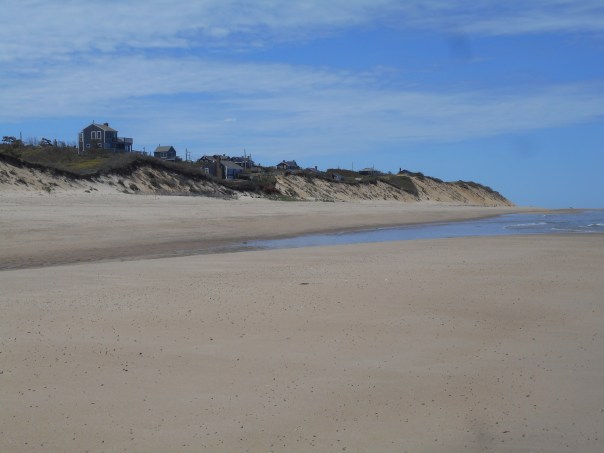
On its eastern shore, Cape Cod loses about three feet of land every year. At its narrowest point just south of Wellfleet, little more than a mile of land separates Cape Cod Bay from the Atlantic. Given the current rate of erosion, the outermost peninsula of Cape Cod will become an island separated from the mainland in less than two millennia. Even on the time-scale of a human life, the rate of erosion is unmistakable. Glancing up at any seaside cliff, one is likely to see the underground remains of society ghastly exposed. Drainpipes emerge from the cliffs, leading nowhere, draining nothing. Electrical cables dangle limp and useless. Large chunks of asphalt lie at the base of the cliffs, evidence of past roads and parking lots. All of this evidence points to the fact that the eastern edge of the Cape was once purposely settled with the intention of staying permanently. But not even modern development could stand up to the forces of erosion over time. Eventually, even this evidence of habitation too shall disappear.
The ghost of previous settlement becomes apparent in the seaside cliffs. Drain pipes and old wiring poke out from the cliffs above (@Nauset Beach).
Along with the sand, much of the history of Cape Cod has fallen down the cliffs and disappeared into the hungry mouth of the ocean. The first twin lighthouses at Chatham have long since tumbled into the sea; later lighthouses would be built on moveable bases to prevent a similar fate. The landing spot of the first trans-Atlantic telegraph cable connecting America to continental Europe in 1879 is no more; that spot where messages were relayed across the ocean now lies more than 300 feet out to sea. As the pursuit of land by the ocean continues, more buildings face the dilemma of either moving or falling into the ocean. Man’s few accomplishments, even as groundbreaking and historic as they may be, are ultimately fleeting and ephemeral. Nothing can stop the onslaught of the elements over time. The ocean serves as a reminder for man to keep his humility.
The view is one thing, but these houses will soon have to face destiny: move or be swallowed by the ocean. (@ LeCount Hollow Beach).
Though the eastern shore is rapidly eroding and the Cape loses about 5 to 6 acres of land every year, not all of the elements work to destroy land. Land that is lost will eventually result in land that is created. However, on Cape Cod it is a losing battle; for every acre of land lost, only ½ acre of new land will be created. The rest of the sediment vanishes into the ocean depths. Summer winds transport eroded material along the shore southwards, adding to the sand island of Monomoy off the Cape’s elbow. Strong winter Nor’easters transport most of the sediment down-cape to the curling fist at Provincetown. Here, currents slow and the transported sediments are deposited, forming the classic recurve shape of a sand spit. At the very tip of the Cape, the area known as the Province Lands has been formed very recently, an accumulation of the sandy corpse of the easternmost Cape. The Province Lands are not a glacial feature, but a geologically infantile accumulation of water-deposited sand. But even where deposition occurs, erosion is present also. Just south of Race Point, where sand from the eastern Cape is coming to rest, waves off of Cape Cod Bay move sand south around the Provincetown Harbor towards Long Point. Erosion happens on many scales—a fractal pattern of sand spits develops.

Not all of Cape Cod is disappearing: sand from the eastern shore eventually settles in places like Race Point at the northern tip of the peninsula (Race Point Lighthouse).

Where there is deposition there is also erosion: Herring Beach, just south of Race Point where a road and parking lot are irreversibly disappearing into the ocean.
Water is one factor in the continual re-shaping of Cape Cod; wind is another. Unprotected from higher surrounding landforms, Cape Cod is continually ravaged by winds whipping across the seas. Historically, the erosional effect of these winds has been tempered by a layer of vegetation growing on the sandy soil. Though the soil on Cape Cod is poor and holds very little organic matter, these fragile soils once supported great hardwood and softwood forests. Millennia after the glaciers retreated, pioneering species gradually built a thin soil in the sand; larger and lusher trees were then able to grow, a magnificent forest of large pines, oaks, and in places even the nutrient-demanding beech tree. Upon landing in the New World at the Province Lands in 1620, the Mayflower Pilgrims scouted the area and remarked on the majesty of the Cape’s forests, being “compassed about to the very sea with oaks, pines, juniper, sassafras, and other sweet wood.” Though the pilgrims moved on to settle permanently in Plymouth, more European settlers were soon to follow in the late 1600’s and early 1700’s. With rapidity the native forests of the Cape were cut down for firewood and agriculture; the thin fragile soil was exposed to the unforgiving winds. The layer of green that held down the topography of Cape Cod was removed, and the fertility of the soil lost with it. By the mid-1800’s, man’s feeble attempts to eke out a living by farming the Cape all but ended. Today the stabilizing forests are in regeneration, the scraggly pitch pines being the first to reappear where man once tilled.
This story of human-induced erosion played out all across the Cape, but nowhere else was its effect as marked or as lasting as in the Province Lands. Though the native vegetation recolonized most of the Cape, not all places were able to return to mature forests. The sandy hills of the Province Lands, once denuded of their forests, created a perpetually shifting dunefield. As the dunes go on their continual relentless march, human habitations and historic buildings are engulfed by the drifting dunes without human intervention. Even today’s darling jewel of Cape Cod tourist towns, Provincetown, was critically threatened by the shifting sands; the fledgling town was close to being abandoned in the 1700’s as sands started to engulf the village. To allow the blowing sand to pass underneath unopposed into Provincetown harbor, residents began building houses on pillars. Efforts to combat the unceasing erosion happened nearly as soon as the dunes started moving. As early as the 1650’s, a law was passed in Provincetown forbidding the trampling of dune vegetation. Such conservation laws continue today, and Provincetown was saved from imminent burial. But the tip of the Cape is far from its pre-colonization state; the winds and sand continue to remind inhabitants of this fact. Paths and roads along Cape Cod’s sandy tip are continuously blanketed by a layer of sand. The Province Lands Dunes—as beautiful as they may be—are a man-made creation, one that has outrun his own control. Though the initial disturbance was created by humans, the relentless winds took over the process of dune movement and continues on to this day.

Erosion is a force on land as it is at sea. Strong winds off the ocean keep a migrating dunefield at the Province Lands.

No structure is safe: without the efforts of human intervention, the Old Harbor Life Saving station would eventually become buried in sand.

Provincetown today. In the 1700’s, blowing sand from the Province Lands threaten to swallow this seaside town.
Everywhere on Cape Cod, change to the landscape is occurring. Much of it—the seemingly inconsequential movement of a single salt grain—happens ever so minutely and imperceptibly. Cumulatively, the effects of erosion serve as a reminder of the impermanence of humans and their accomplishments. Nothing, ultimately, lasts forever. Not even a feature as large and well-known as Cape Cod can last. Ultimately, all things are washed away into the sea.
For Additional Reading:
O'Brien, Greg (2003). A Guide to Nature on Cape Cod and the Islands.
        Hyannis, MA: Codfish Press.
Strahler, Arthur N. (1966). A Geologist's View of Cape Cod. Garden City,
        NY: The Natural History Press.
