Category Archives: Bicycle

The Socially Distanced Cyclist: 16 Days, 1,170 Miles, and Minimal Human Contact Around the Coast of Lower Peninsula Michigan
From August 9 to 24, 2020, I took a solo, self-supported bicycle trip to explore the coastline of my home state, the great state of Michigan. Being the Great Lakes State and a water wonderland, Michigan offers 3,224 miles of freshwater coastline to explore as well as 124 lighthouses, both of which are the most of any state. The following is a summary the trip, encompassing 16 days, 1,170 miles, and following the coastline of Lake Michigan and Lake Huron around Michigan’s Lower Peninsula.
Approximate Route:

Day 1: Familiar Territory
Zeeland to Muskegon State Park: 67 Miles


It was a beautiful summer Sunday afternoon when I finally departed for my trip after a much longer than anticipated morning of final preparations. Bluebird skies and temps in the 80’s made it a day more fitting for a beach holiday than a long, sweaty bike ride. I would start the trip covering very familiar territory, a survey of the Lake Michigan beaches within just a short driving distance of where I grew up. I hopped on my overloaded bicycle and listened to the new squeaks and groans as the immense weight found its equilibrium on my old Cannondale, crossing my fingers that no spokes would snap (wanting to keep myself socially-distanced as possible, I chose to pack around 35 pounds of food so I wouldn’t need to re-provision the entire trip). My first leg would be the twelve mile distance to the white sand beaches of Holland State Park, with a ceremonial stop to see my beloved ‘Big Red’ Lighthouse, which would mark the first of many lighthouses I would stop to see on the trip.
The Holland area boasts many wonderful non-motorized recreational paths, and I followed one of them along Lakeshore Drive, past many lakeshore mansions, nearly all the way to Grand Haven. Grand Haven State Park, another beautiful white sandy beach, was packed with beach revelers on such a gorgeous day. From Grand Haven, I crossed the drawbridge over the Grand River and proceeded northward to Muskegon. This first day of the trip was marked by getting through some of the bigger metropolitan areas on the lakeshore to the less developed lands of the northern counties. North of Muskegon lies Muskegon State Park, a much quieter and forested lakeshore dune park than both of the state parks I had visited earlier. It was at Muskegon State Park where I would first camp for the night, and, as an omen for a good trip to come, I found a $20 bill on the road leading to the park.
Day 2: Storm’s A-Brewing
Muskegon State Park to Ludington: 72 Miles


Day two started fairly leisurely on the sandy beaches of Muskegon State Park, followed by a stimulating up-and down ride through the tree-covered dunes to the Blockhouse, the highest point in the park which offers great views of the dune ecosystem. Continuing northward, I followed the aptly-named Scenic Drive paralleling the lakeshore until I reached White Lake and the twin villages of Whitehall and Montague. As recommended, I found the Hart-Montague Trail, which was Michigan’s first Linear State Park and one of the earliest instances of Rail-to-Trail conversions in Michigan (1991). The Hart-Montague Trail runs for 22 miles and connects several small country towns that offer ice creameries and small cafes. Being a former railway, the trail is undeniably flat and straight, with mostly shrubs and brush for scenery. A few miles shy of Hart, I got the itch to return to the lakeshore for more expansive scenery and some hills for interest. I turned west towards the lake and the sand-buggy enclave of Silver Lake. Though I yearned to make the short detour to the remarkable Little Sable Point Lighthouse in Silver Lake, dark ominous clouds had begun building to the west.
I followed roads along the lakeshore through the city of Pentwater and past the cottages of Bass Lake. A few miles south of Ludington, the road passes right by the Ludington Pumped Storage Plant, once the largest pumped storage plant in the world! During the night, when there is excess electricity generated, the plant will pump water from Lake Michigan up into a 1.3 square mile reservoir over 350 feet above the lake. Releasing this water during the day generates supplemental electricity during peak demand. I stopped to gawk at its massive industrial workings, until a security guard came and asked me to leave. The guard said they were shutting down the overlook due to impending weather and showed me the radar on her phone. Yikes! I made a mad bike dash down from the high dunes to the city of Ludington, where I fortunately was able to set up camp before the heaviest rains set it. It was an eventful night as lightning flashed and thunder cracked overhead, but this would prove to be the only rain encountered on the whole trip.
Day 3: This is Hilly Amazing!
Ludington to Sleeping Bear Dunes National Lakeshore: 78 Miles


The storms had passed during the night leaving me with wet gear, but a warm sunny day proved to be in order once again. North of Ludington, Hamlin Lake and Nordhouse Dunes (Lower Michigan’s only federally-designated wilderness area) block road access to the lakeshore, so I took an inland route of country roads through the matrix of forest and small farms. Riding into Manistee took me back to the lakeshore, and proved to be stop with plenty of great parks to relax at along the lakefront. A few miles north of Manistee, while riding on Lakeshore Road, I got caught up in paying too much attention to a car behind me as I looked to turn left towards the beach access. My front wheel slipped off the paved roadway immediately bogging down in the soft beach sand and causing a slow-motion flip over the handlebars. Aside from a few superficial scratches on my hands, knees, and bike, I was shaken, but OK.
I continued on, albeit more wary of soft shoulders now, around Portage Lake and the small town of Onekama. Onekama is the southern terminus of Michigan Highway 22 (or M-22), that famed route whose highway sign is emblazoned on merchandise and bumper stickers all over Michigan. Reaching M-22 proved a dramatic change in riding conditions; here, the hills began. Whereas up until now things had been remarkably flat, M-22 began a series of long, winding, gradual 1-to-2 mile climbs up a sand dune, followed by a speedy descent on the other side. I maxed my downhill speed out at 39 MPH, which on a fully-loaded bicycle is simultaneously exhilarating and terrifying. I broke up the hill climbs with stops at the little Victorian town of Arcadia’s city beach, and at the much more bustling tourist town of Frankfort. I then turned my route inland toward the town of Beulah, in search of cherry pie and wine. Riding from Frankfort along the sizable Crystal Lake proved no relief from the hills, and slower travel over the terrain caused me to miss out on the treats found in Beulah. Hungry and exhausted, I made my camp for the night just a few miles to the north in the Sleeping Bear Dunes National Lakeshore.
Day 4: I Bearly Got Anywhere Today
Sleeping Bear Dunes National Lakeshore: 37 Miles


However exhausted I was from the hill climbs the day before, I woke up very excited for the route I would cover today. I would be traveling through the Sleeping Bear Dunes National Lakeshore, perhaps the most scenic stretch of land in the Lower Peninsula (indeed, Sleeping Bear was named ‘The Most Beautiful Place in America’ by ABC’s Good Morning America in 2011). My bike, however, seemed less up for the challenge. As I had feared, all the popping and groaning coming from my crank were signs that my bearings were going bad, and my crank assembly had been growing disconcertingly looser and looser since day two. I would need to make a pit-stop to have that taken care of before I found myself stranded with no pedals to pedal.
I followed the quiet stretch of M-22 into the tourist outpost of Empire, where I met up with the Sleeping Bear Dunes Heritage Trail. This trail winds through the woods through most of the park, providing most excellent riding scenery. The trail also goes over some very steep dune sections and around some very sharp curves which makes for a sendy route to keep riders on their toes. Highly recommended is the Pierce-Stocking Scenic Drive, which winds a course of seven miles over some of the biggest dunes in the park and past some of the best vistas of Lake Michigan on top of the 400-foot tall sand dunes. Unfortunately for me, and maybe fortunately for my bike, the Pierce-Stocking drive was closed in 2020 due to road construction. However, a short distance north is the epic ‘Dune Climb’, a large active dune blowout that guests are encouraged to climb. The vantages from the top are quite spectacular, and offer sweeping vistas of Lake Michigan, the dune systems, and the valleys inland. Sleeping Bear Dunes also offers opportunities for history hounds as well. Just north of the dune climb is Glen Haven, a former fishing company town that the National Park Service now maintains as a historic village. Tucked in pockets around the park are also the barns and farmhouses of homesteaders of yore. In the course of time, most homesteads folded in the region, and the main economic driver switched to tourism.
I finally stopped to have my bike repaired in Glen Arbor, and the mandatory afternoon of downtime was well spent enjoying a swim in the crystal blue waters of Lake Michigan, as well as doing some tourist shopping in Glen Arbor itself. Not a big day distance-wise, but one of the best places just to enjoy some time in the splendid destination.
Day 5: Up and Down on Leelenau
Leland to Traverse City: 84 Miles


Back in 2012, I had taken a short bike vacation with my parents to the Leelenau Peninsula, and this area offers so much for the bicycle tourist on shorter trips as well as longer ones. The bigger towns of Leland, Northport, and Suttons Bay all offer their own vibe and tourist amenities. I started my day by following M-22 into Leland, of which any stop requires a mandatory visit to the historic and artsy Fishtown. A pleasant and lightly-trafficked ride north on M-22 took me to the quiet town of Northport. About an 8 mile ride north of Northport, past many cherry orchards, I reached the very tip of the Leelenau Peninsula which is home to a state park and the impressive Grand Traverse Lighthouse. The lighthouse was open to tours, though the tower was closed due to COVID.
On my way south on M-22 towards Suttons Bay, just past Omena, I crossed over the 45th Parallel (I had actually crossed over it earlier in the day between Leland and Northport), which, being the geography nerd that I am, necessitated a reason to celebrate. The closer I got to Suttons Bay, the more traffic M-22 picked up, and the worse shape the road became. Though riding M-22 next to Grand Traverse Bay was scenic, I was happy to beat the traffic by picking up the TART Trail (Traverse Area Recreation and Transportation Trail) going into Traverse City. Being the ‘Cherry Capital of the World,’ I biked past many cherry and fruit orchards on my way into the city.
Day 6: On a Mission
Old Mission Peninsula to Charlevoix: 78 Miles


The start of the day would take me onto the Old Mission Peninsula, the very long and narrow stretch of land that neatly divides Grand Traverse Bay in two. I peddled up the Peninsula on the west side’s Peninsula Drive, which offers a very quick and flat route to the tip, going past miles of miles of really fancy waterfront properties along the way. At the tip of the Old Mission Peninsula lies the Mission Point Lighthouse and a nice beach with crystal clear waters. The route back to Traverse City, along the main highway M-37, offered quite a contrast to the solitude and ease of Peninsula Drive. M-37 goes through the middle of the Peninsula, meaning the road goes up and down many hills as it winds its way mostly through vineyards. Though the hills were challenging, they did provide some incredible vistas of vineyards and Grand Traverse Bay. Had it not been before 10AM, I would have stopped for a tasting.
Once back into Traverse City, I caught the TART Trail to its eastern terminus in Acme, a few miles away. I was glad to avoid the heavy development and tourist traffic along that stretch of US-31. Once the path ended, I followed the signed bike route through some bucolic country acres until I ended up at US-31 again. During route planning, I had wanted to bike that stretch of US-31 as it passes on a narrow strip of land between Lake Michigan and both Elk Lake and Torch Lakes. In hindsight, this was the only section of my route that I wish I had changed. US-31 along that stretch has only a narrow, crumbling shoulder, and the summer tourist car traffic is constant. Even worse, the route has absolutely no views of any lake along the way. As a plus side, though, the heavy tourist traffic does bring with it an abundance of roadside food, fruit, and sweet stands, and Elk Rapids makes a nice town to stop at. Given that it was an exasperatingly hot and sunny day, I made my fill of stops along the way to replenish my belly and refill my electrolytes with some pasties, pastries, and apple cider.
Day 7: Through the Tunnel of Trees
Charlevoix to Cross Village: 81 Miles


Whereas the previous two days were spent biking around the Grand Traverse Bay, today I would bike around the Little Traverse Bay. First stop of the day was in the harbor town of Charlevoix, outside of which I picked up the Little Traverse Wheelway bike path. With the underlying bedrock of the region being limestone here, I made several lengthy stops along the lakeshore to try my hand at fossil hunting. Being so close to Petoskey, I was really hoping to find a stellar specimen of the city’s namesake and Michigan’s state rock (even though Petoskey stones are indeed a fossil, they are not Michigan’s state fossil). Alas, good specimens of Hexagonaria coral (AKA Petoskey stones) were difficult to find, but it doesn’t take an expert paleontologist to soon pick out many other fossils in the mix; fossilized horn corals, bivalves, brachiopods, and crinoids all make the lakeshore a Devonian paleontologist’s playground. Following the nicely-paved Wheelway around Little Traverse Bay will take you to the towns of Petoskey and Harbor Springs, both of which offer plenty of dining and shopping amenities. Petoskey offers a large historic downtown area built into a hillside, whereas Harbor Springs caters to the yacht club upper-crust.
Past Harbor Springs, following Michigan Highway 119 (M-119) is both the motorist and cyclist eye-candy route known as the ‘Tunnel of Trees’. The Tunnel of Trees is a splendid, curvy, 1 1/2 lane highway that encourages you to slow down and enjoy being immersed in the trees as the highway meanders along a sand dune bluff for nearly 20 miles. Traveling, as I was, on a mostly cloudy evening, I encountered very little auto traffic (I let my eyes wander once again, forgetting entirely my days-earlier episode of crashing my bike). At the northern end of the Tunnel of Trees is the tiny settlement of Cross Village, most notably known for its iconic roadhouse, the Legs Inn. In the 1930’s Polish immigrant Stanley Smolak, along with the help of local Odawa craftsmen, began to build the fantastical building using local stone and driftwood. It is highly recommended as a place to eat, or at least walk in and feast your eyes on the décor. Wait times often exceed one hour. Though a hot meal and a beer sounded nice after such a long day, I was burning daylight and had to get to my campsite near Wilderness State Park.
Day 8: In the Straits, not in dire straits
Wilderness State Park to Mackinac Island: 45 Miles


Wilderness State Park is a fantastic, remote expanse of land on the northwest tip of lower Michigan. It offers wide swathes of pine forest and vast expanses of sand dunes, and is highly recommended to spend a full day there. My time in Wilderness State Park would prove eventful. I had just started biking for the day when I came around a corner and saw two young men frantically waving for me. I caught glimpse of a motorcycle stuck under a truck, which is what they were making a big fuss about. I stopped to help the two guys, both named Tyler, incidentally, to get the motorcycle out from under the truck. By that time, I had already pieced together the narrative that the man with the fresh patches of road rash had lost control of his motorcycle going around the curve, and had slid under the parked truck. Fortunately everyone was OK, and I helped Tyler clean up his road rash a bit. Of the three of us there, only my flip phone had cell service, and I stayed with them until they arranged a tow. Flip phone for the win!
Since I no longer had time to explore the vastness of Wilderness State Park, I picked my way along rough rural roads in Emmet County towards the very tip of the Mitt at Mackinaw City. Along the way, however, I couldn’t resist stopping when I saw a sign for the McGulpin Point Lighthouse (which, by the way, you could actually climb the tower). From the McGulpin Point light tower, I could get a great view of the Mackinac Bridge spanning the Straits of Mackinaw. I was at the tip of the peninsula, but the Mackinac was a bridge I would not cross (at least not on this trip). Nearby the lighthouse is the Headlands International Dark Sky Park, and the region is perfect for stargazing on a clear night.
Now that I was halfway through my ride and at the tip of the Peninsula, my crowning stop would be an afternoon spent on Mackinac Island, Michigan’s iconic and premier island destination. A former British fort and a tourist destination since the mid-1800’s, Mackinac Island was once even briefly a federal National Park (1875-1895). Today, the island is known for its bikes and horse-drawn carriages, its Victorian architecture, its fudge and tourist shops, and for being carless. It is a half-hour ferry ride to the island from Mackinaw City, and to get to the ferry terminal you have to pass through all the shops of downtown Mackinaw City that are hawking fudge and T-shirts. Once you land on Mackinac Island itself, you’ll be in downtown and will walk past all the shops hawking the same fudge and T-shirts as the mainland. But when you’re on the island, it’s special, and I did the touristy thing of buying fudge, popcorn, and postcards. The island is also great for history buffs, given Fort Michilimackinac and other historic buildings to tour, but I was there for the bike riding. A right of passage on the island is to bike the 8 mile loop on M-185 that rings the island. I had biked around the island once before on a family trip when I was in fifth grade, but biking on my own as an adult was so much better. Of course I had to make a stop at some of the iconic geological formations such as Arch Rock and Skull Cave. And there was no better way to cap off the day than by getting ice cream from the shop below the Grand Hotel’s world-record 660′ long front porch.
Day 9: Lonesome Limestone Highway
Mackinaw City to Thompson’s Harbor State Park: 74 Miles


United States Highway 23 offers a dramatic contrast to the commercialism of Mackinaw City. Never before had I been to northeast Lower Michigan. It is an region of small towns separated by large distances all built on the extractive industries. From Mackinaw City to Cheboygan, the North Central State Trail follows an old railroad grade paralleling Highway 23. Though the crushed gravel of the state trail was nice, I found I preferred the feel of pavement and the glimpses of Lake Huron that riding on the road afforded me. Traffic was light and the shoulders were wide, which meant great riding conditions.
The surrounding waters of Lake Huron are extremely treacherous, and have claimed hundreds of ships and lives over the centuries. These shipwrecks are all protected within the Thunder Bay National Marine Sanctuary. Forty miles from the Straits of Mackinac is the Forty Mile Point Lighthouse. Several shipwrecks lie in shallow water just offshore, but the remains of the 1905 wreck of the J.S. Fay lie on the beach near the lighthouse. Snorkeling, SCUBA diving, kayaking, or glass bottomed boat tours are all the best ways to see the wrecks.
From Forty Mile Point, one can get on the paved Huron-Sunrise Trail, which leads to Rogers City. Though Rogers City is small, its status as the only town of 1,000 or more people for 30 miles in either direction means that it has all the amenities a person would need. Rogers City is built on mining—mining the fossil-rich limestone bedrock that dominates the region. The limestone is crushed and used as an ingredient in cement, and Lake Huron provides easy access for shipping to distant markets. Outside the city is a special overlook that peers into the massive strip mine that gives Roger’s City its lifeblood. The Calcite Quarry, at over 1,800 acres, ships out 7 to 10 million tons of limestone each year.
Leaving Rogers City early in the evening, the sun was beginning to shine lower and lower on the horizon, while the blue open skies made the late sunshine feel quite tangible. I took a detour off of US-23 at Thompson’s Harbor State Park to search for the Presque Isle Lighthouses. Without directions or a detailed map, I followed an unnamed dirt road hoping it would take me to the lighthouses. The road dead ended at the outlet where water from Grand Lake flows into Lake Huron. The low gleaming sun, the slight warmth in the gentle breeze, the sound of the rocks rolling in the surf—it aligned all too perfectly. I had to stop right there for the day—I had to sit down and just bask in the beauty of the experience. If anything, that evening spent on the beach of Thompson’s Harbor was the defining spiritual experience of the trip. The video encapsulating my experience is included above.
Day 10: Here On Huron
Thompson’s Harbor State Park to Oscoda: 76 Miles
")


After my euphoric evening at Thompson’s Harbor State Park, I had to follow up with nothing short of a pre-breakfast swim in Lake Huron. My morning route would continue around Grand Lake to the small sleepy enclave of Presque Isle. I would find both the old and the new Presque Isle Lighthouses on a peninsula, and, not unexpectedly, both were closed for the summer. Nevertheless, taking the detour around Grand Lake to those small communities and idyllic harbors was well worth it. After passing another large limestone quarry, I reconnected to US-23 and had a short ride into the city of Alpena.
Alpena hails itself as the ‘Sanctuary of the Great Lakes’ owing to its location at the center of the Thunder Bay National Marine Sanctuary. It is a large city, as far as cities in northeastern Michigan go, and along with the extractive industries of fishing, lumbering, and limestone quarrying, Alpena boats a modest maritime tourist economy as well. Unfortunately the highly acclaimed NOAA Museum and adjoining glass-bottom boat tours were closed due to COVID. At this point in the trip, I had grown terribly tired of the food I had packed from home, so I stopped in downtown Alpena to get the greasiest cheeseburger Alpena could offer. While seated at the restaurant, a middle-aged couple started up a conversation by saying that they had seen me yesterday riding from Mackinaw City. We chatted a while about our Michigan travels, and they seemed thoroughly impressed by my stamina. They also paid for my meal.
I left Alpena headed south on US-23 on the mostly empty road past the endless forest. A peculiar place to stop would be Ossineke, where giant sculptures of Paul Bunyan and Babe the Blue Ox great travelers on the highway. Nearby, a gigantic Jesus holding the earth aloft in one hand beckons visitors to come visit the Dinosaur Gardens Prehistoric Zoo, an eclectic and anachronistic mix of cavemen, dinosaurs, and Christianity. By the time I was ready for a break, I was passing by the small town of Harrisville, and I saw a sign for an outdoor concert at the lakefront pavilion. It was some good foot-tapping folk music being played, and after a few songs an announcement was made that it was the organizer of the concert series birthday today. A homemade carrot cake was cut up to celebrate. I was invited by a women to grab a slice. What great small-town hospitality! South of Harrisville, US-23 travels right next to Lake Huron, on what is called the ‘Sunrise Coast’. In a long stretch from Harrisville to Oscoda, the lake is lined with second homes and vacation rentals. I think I finally found where most of the east-siders go on their summer vacations.
Day 11: To the Thumb Pit
Oscoda to Standish: 71 Miles


The twin villages of Au Sable and Oscoda mark the finish line of one of Michigan’s most epic races: The Au Sable Canoe Marathon. In the race, competitors start 120 miles upstream in Grayling, paddling through the night to reach the finish line near Lake Huron. The race was cancelled in 2020, but seeing so many fine rivers as I biked along the coast made me itch to get out and paddle again.
A short distance later, I would be coming upon the start of the ‘Thumb Pit,’ better known as Saginaw Bay. The Tawas Point Lighthouse marks the start of the bay on the northern end, and Tawas City is a small tourist enclave. Continuing south on US-23, the highway is flat and runs right along the lakeshore. The tourist resorts and second homes disappear, and the landscape consists of forest and utilitarian buildings. Maybe it was something about this road, or maybe it was because I just started to put my head down and ride, but I began to notice an abundance of quarters, nickels, and dimes scattered on the shoulder. Another roadside find was a ‘Don’t Tread On Me’ flag, which was evocative of the region’s independent and libertarian leanings.
Day 12: Thumbs Up
Standish to Port Austin: 77 Miles


Today I would round Saginaw Bay and enter Michigan’s Thumb. Pure geographical curiosity had me wondering what it would be like to visit, though I have heard that the Thumb is very flat, rural, and agricultural. The rumors proved true: the Thumb is incredibly flat, rural, and agricultural. Very small farm towns dot the landscape. Biking south on M-13 going into Bay City, I passed through Pinconning, Michigan’s Cheese Capital. On the Thumb, the town of Sebewaing has a large sugar beet processing plant. It was not until the very tip of the thumb, in the towns of Caseville and Port Austin, where vacation homes and tourist attractions began to sprout up along M-25 by the lakeshore. The thumb-tip also offers a couple of nice state parks with sandy swimming beaches.
Day 13: Last Day Along the Lake
Port Austin to Lakeport: 84 Miles


Starting from the tip of the Thumb, today would be my last day biking along the lakeshore as I made my way south on M-25 towards Port Huron. M-25 runs right along Lake Huron, passing many small towns along the way. Even though the route is right next to a Great Lake, it remains agricultural and undeveloped. I biked past the historical company town of Huron City and then past the Point Aux Barques Lighthouse and former U.S. Life Saving Service Station. I continued biking past many sleepy towns enjoyed by the R.V. crowd, until I passed through more touristy enclaves like Lexington and Lakeport as I neared Port Huron.
Day 14: Eastward
Lakeport to Flint: 96 Miles

Alas, all good things must come to an end, and I was about to wrap up my travels along the Great Lakes and start the long trek eastward back to my starting point in Zeeland. I couldn’t help but say goodbye to Lake Huron with one final swim at Lakeport State Park. From Lakeport I would pedal eastward through the farm country in the heart of the state. I passed through small towns named Yale, Lynn, Capac, and Dryden. The roads were rough and had limited shoulder, and I bet that road bikers are a rare occurrence there. However, even with the unseemingly busy roads and all the trucks trying to get past me, every driver was courteous. By the time I biked to Metamora and Hadley, the farmland had turned to hills and forest. I would end the evening on the outskirts of Flint, after a very long, hot and sunny day.
Days 15 & 16: Wrapping Up
Flint to Middleville to Zeeland: 115 & 35 Miles

One final, scorching hot day was ahead of me as I aimed to make it to my friends Robert and Becky’s house in Middleville for the evening. From the outskirts of Flint, I was immediately back into farm country. I would pass through Durand, home of the Michigan Railroad Historical Museum. I would also pass through Laingsburg, where I began running into fleets of spandexed cyclists out for a Sunday morning ride. Out of Laingsburg, I would follow country roads that ran along the crisp and cool Looking Glass River, being thankful for the trees lining the road that provided some measure of relief from the sun. Once past the outskirts of Lansing, it was all sun-beaten farmland until Middleville. Wanting to avoid traffic, I wandered down country roads, meandering generally East and South towards my destination. While I succeeded in avoiding traffic, I also never ran into the gas station that I had optimistically been counting on to replenish my desperately low electrolytes. By the time I arrived at Robert and Becky’s house, it was well past sunset. An incredibly long day, but one the prospect of seeing old friends again had motivated me on towards.
From Middleville, it was a chip shot of a day to finish the remainder of the trip back to Zeeland. More meandering and country roads, and the unanticipated stretch of country gravel, but 35 miles later I had made the trip complete.

Fat Bikes and a Sandy Neck

The Specialized Fatboy
As an avid cyclist (but only an intermittent mountain biker), I decided it was finally time to try my hand at riding a fat-tire bicycle (or a fat bike, or a ‘Fattie,’ as some would say) just to see what all the hype around this new bicycling trend is about.
And so, I rented a Fattie for the weekend to throw my all at it. It was easy enough to do; I even got the idea when I was perusing my local outdoor sports store and asked if they did rentals. At a rate of $80 per 24 hours, it was a pricey commitment but still do-able, especially considering the cost of a new fat bike. The shopkeepers ended up fitting me out on the Specialized Fatboy. Its bright orange color was flashy and just begging for rugged adventure.
As I drove back to camp with the bike securely stowed in my hatchback, the thought that this bike cost fifty percent more than my car itself crossed my mind just a number of times (read: $3,000). I really didn’t want to risk damage to such a pretty penny merchandise, but to heck with it—I was ready to see what this bike could do.
There was a steady drizzle in the air the afternoon I picked up my rental, and that rain meant mud—and lots of it. The trails back at camp were profusely waterlogged, leaving plenty of puddles to splash around in as I got acquainted with the Fatboy. Getting prepared to ride by unloading the bike from my trunk, I really noticed how unexpectedly light the bike was. It’s the carbon fiber frame that reduces the weight, but also substantially increases the price.
I eased into riding my new Fattie by starting on some simple double tracks in the woods behind camp—just to get acquainted to the feel of riding. Much like any other bicycle, the fat-tire bike is simple to operate. Just put your legs on the peddles and go. The fat tires though, as one would expect, do make a noticeable difference in riding. Acceleration is markedly slower, and on a flattish surface my peddle strokes seemed to be transferring more energy into bouncing the entire bicycle up and down on the balloon tires, rather than adding to ground speed. Yet, the Fatboy plodded on like a tank. The single front chainring is small, which allows lots of torque to be put on the chain. That makes the Fatboy easy enough to start riding in difficult terrain, but it also makes it easy to spin out the tires when starting out in a lower gear. The rear cassette offers 12 speeds—plenty of options for any riding conditions, but way more than I needed for my simple jaunt.
After a warm-up on the double track (including riding through the pervasive mud puddles), I was ready to move on to the advanced single track—tight curves, sudden drops, and a variety-pack of obstacles in the way. The Fatboy handled it all like a champ. No obstacle seemed too obscene to mow over. The ubiquitous Cape Cod cobbles littering the forest floor were obliterated without a hesitation. Downed logs, even girthy ones, posed little challenge to surmount. Whereas lesser mountain bikes would have backed down and buckled, the four-inch wide tires on the Fatboy conquered any challenge I threw at it. It seemed that the only limitations I encountered on my ride were from my own skills (or lack thereof). Additionally, the front and rear disc brakes came quite in handy for easing my way down steep hills, and when encountering the unexpected obstacle in the slick terrain.
An afternoon of testing out my first Fattie was a success. Uphills, downhills, rocks, logs, puddles, sand, mud, and even riding through Spectacle pond proved no challenge to the Fatboy.

The beach at Sandy Neck
With day one in the books, I took the Fatboy out to one of Cape Cod’s most popular off-roading destinations—the Sandy Neck Conservation Lands in the town of Barnstable. As a prominent feature of Cape Cod geography, Sandy Neck is a long, continuous beach lining Cape Cod Bay comprising a stretch of dunes separating the Bay from the expansive saltwater tidal marshes of Great Marsh. The only land access to Sandy Neck begins, remarkably enough, at the Sandy Neck Gatehouse. On a cool and overcast October morning, I set out to ride the entire length of Sandy Neck, all the way to the fabled Cottage Colony at the tip.
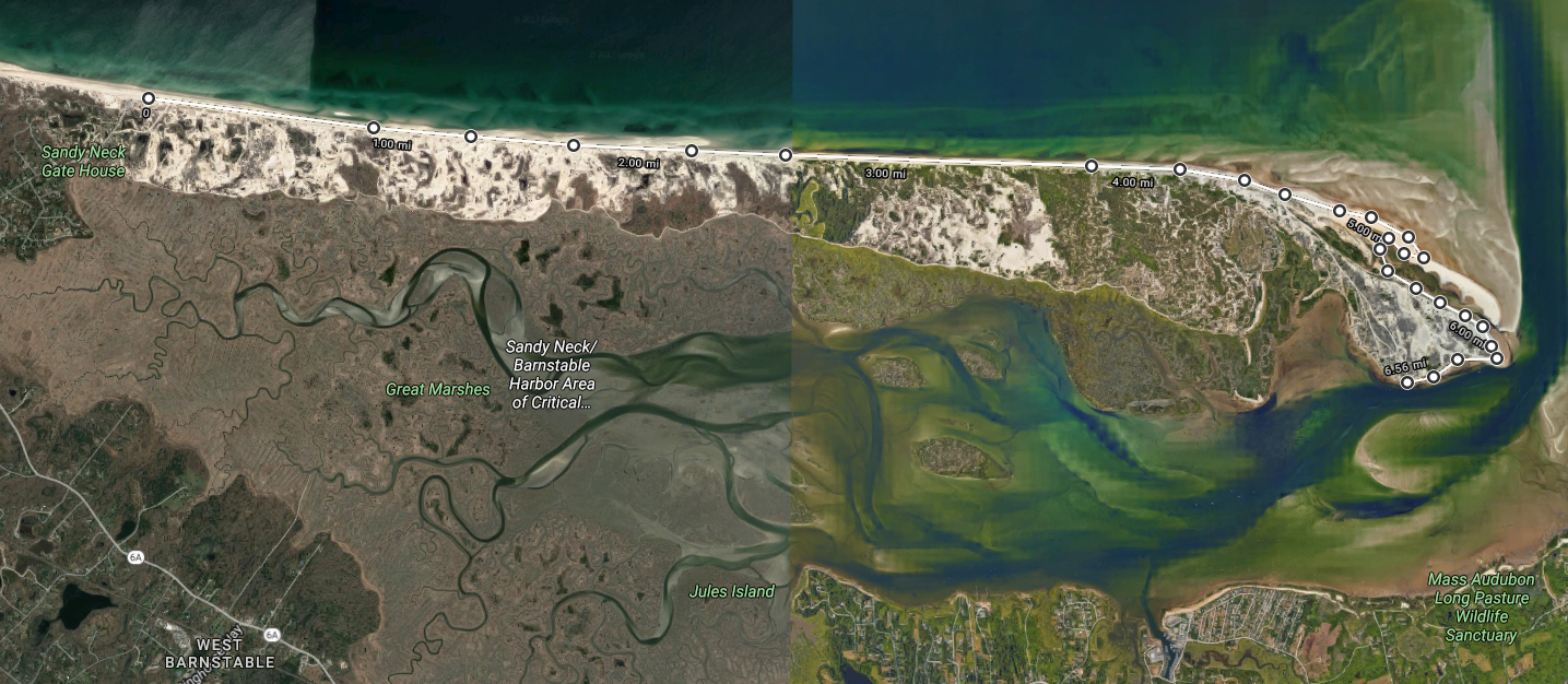
An overview of Sandy Neck, showing the 7-mile route from the Gatehouse to the Cottage Colony
Riding the Fattie on Sandy Neck was a challenge in endurance, both physically and mentally. It’s a seven mile haul from the gatehouse around the tip to the Colony, and with the expansive ocean views, the scenery—though stunning—changes very slowly. Though the terrain is flat the entire way, the beach is a loose consolidation of sand and ocean-rounded cobbles. My peddle revolutions on the ride were just enough to keep me balanced upright, and speed was never a priority. With its fat tires, the Fatboy is very inherently stable, and that stability was the only thing that got me through the beach sand with no wipeouts. All along the ride I had the challenge of adjusting where I was riding to find the optimal traction for the various beach surfaces. And since the ride was on the ocean, it was rather nice to be able to frequently stop and do some beach-combing along the way.

For a name like Sandy Neck, the beach was awfully rocky in places

Horseshoe crab exoskeletons were commonly found washed ashore
It took about one and a half hours to finally reach the Cottage Colony and its lighthouse, which put my ground speed at just over a measly 4.5 miles per hour. I could now take a break and explore this cryptic summer destination. After all, I had earned my right to be there, and had gotten there it fat-bike style too. No maintained roads lead to the colony, so only 4-wheel drives, horseback riders, and boaters can reach the colony. From my observations, I was the only one who had arrived by bicycle.
Being October as it was, the summer cottage colony was practically deserted. I took a break and looked around. Pure Cape Cod right there. A spattering of a half-dozen clapboard shanties springing from the sandy dunes. Weather-beaten, rustic, coastal. The mist blowing into the colony from the Bay and gloomy gray overhead skies created an ambience of a rather sea-beaten place to live.
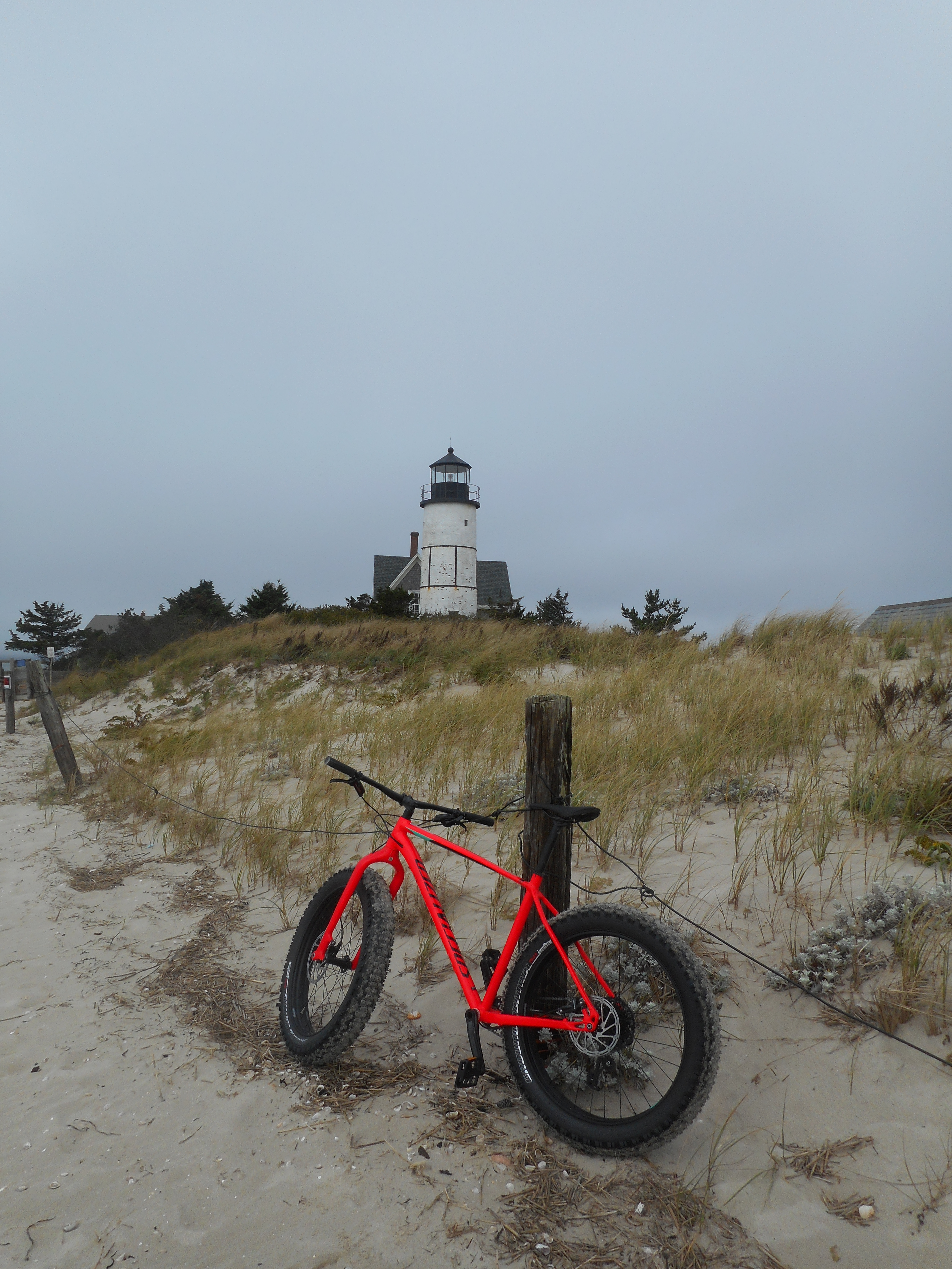
Sandy Neck Lighthouse

Sandy Neck Cottage Colony
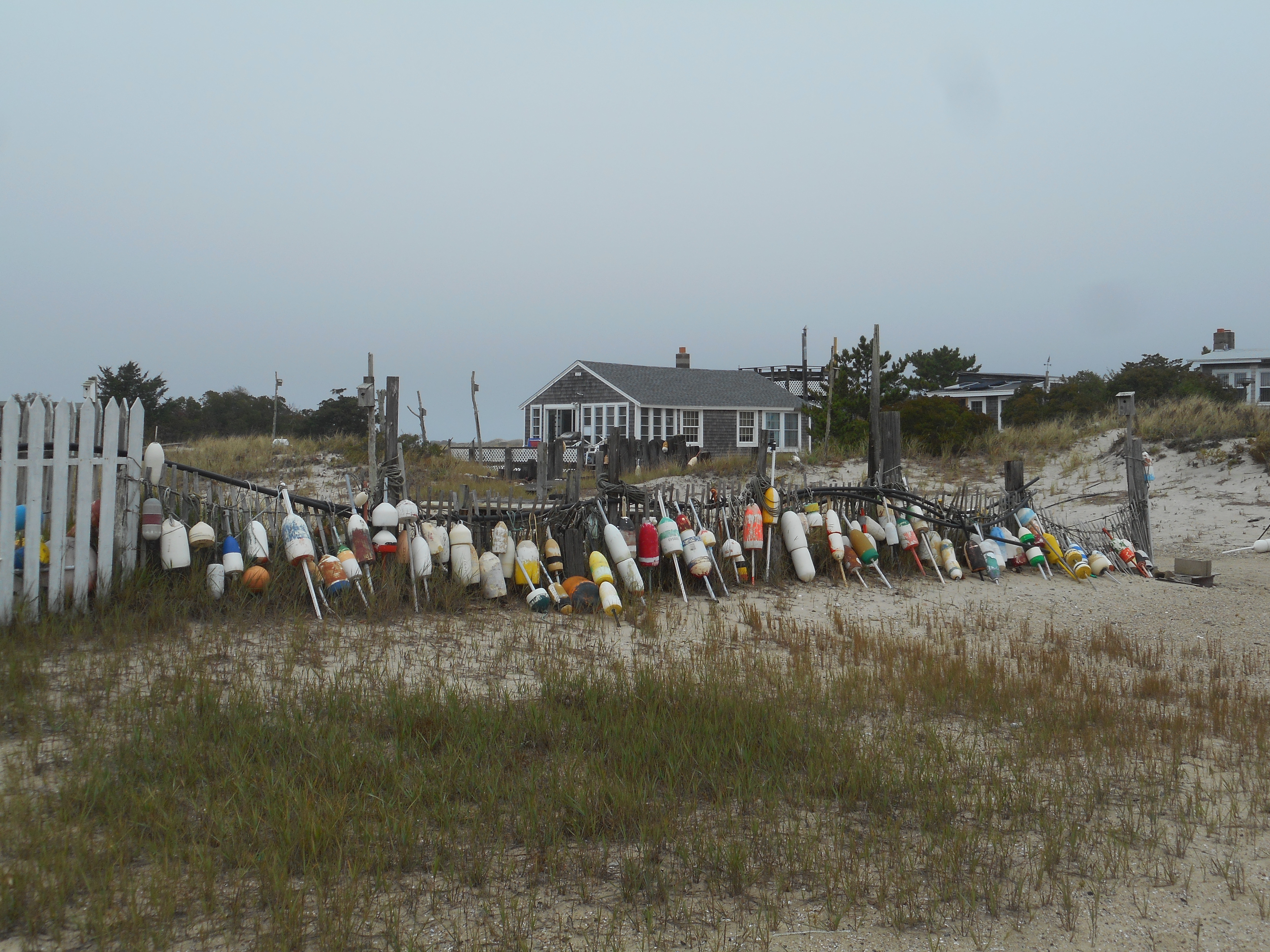
Sandy Neck Cottage Colony
Eventually I left the colony. It was time to head back and complete the round-trip trek. My fat bike had proved me well, and had gotten me places I couldn’t have otherwise. For one weekend, it was quite the experience.


Living Vicariously: A Summer Journey through Letters

I biked across the country this past summer.
No, I didn’t actually bike across the country this summer. But it felt like I was there. A friend of mine, a close pen-pal, was the one doing the biking. Every once in a while I would receive updates from a letter describing the places my friend had biked to and her thoughts on the adventure. If I was on the biking journey this summer, it was only vicariously, through her letters.
It wasn’t necessary to receive these letters in order to learn updates about my friend’s biking adventure. After all, she openly posted photos and statuses about her journey regularly through the democratic medium of Facebook. I followed along closely the progress of her and her partner’s trek. Add in electronic communication through email and text messaging, and I had all the modes of contact I could possibly need to stay in touch right at my fingertips. Why then go through the archaic effort of writing letters, especially when I’d be mailing them to a moving target?
In defense of the waning art of letter-writing, there is something incredibly personal and amicable about receiving a hand-written letter. There is something transcendent about it that quick and easy electronic communication can never replicate. A letter is a physical token, something tangible that puts weight in your hand. Even though far apart, the letter is something that both friends have touched and felt and handled; it’s an object that you both have shared in, that bonds you together. The scrawled handwriting on the pages is unique—artistic forms that can never be duplicated, stemming from the very hand of your friend themselves. Though the physical letter has little extrinsic value in itself, the intrinsic value it delivers is priceless.
Each letter received is a gift. Though you can anticipate a letter’s coming, you can never know exactly when it will arrive. Daily you may check the mail, waiting for the surprise delivered by the postman which brings with it a kind of fraternal pleasure. This hand-written letter, addressed exclusively to you, is a conversation between you and your friend alone. Unlike social media posts which have an extensive audience and beg for viewership, the personal letter has become subversive in our culture. It pronounces that some correspondences are meant to be kept private; some conversations are not meant to be laid out open for the wide world to see. And there is something incredibly special about a friend choosing words to write just to you, personally. Even though the content of my letters is nothing incriminating, nothing risqué, it nevertheless feels like they must be kept private to save the mysterious allure of the written conversation. The bulk of my mail correspondences are of absolutely no interest to the general public. But I like that. I like having people write to me and include in their curation of all the possible topics to write about, those things that they thought would interest me. It is their selection—for me.
I have a handful of pen-pals with whom I keep a semi-regular correspondence. Not all of them bike across the country. In fact, most of the time they are doing quite unimpressive stuff—the ins-and-outs of daily life: discussions of work duties, of visiting friends and of making food, of trifling hopes and dreams, of random thoughts. Though their correspondences may not regularly tell of events on the impressive scale of a cross-country bicycle journey, the content they write is nonetheless the fodder of an impressive life-journey lived by every one of my friends. No matter how quotidian the content of the letters may be, I still live vicariously through those words. My friends may benefit from hearing about my own journey which has taken me to many different places and through many different jobs (and I get a lot of feedback that people wish they were doing the things I’m doing). Still, the reverse is also true: my friends who are more settled, though they may not travel as much as me, are nevertheless leading lives that are incredibly interesting to me. They write about things that I too would love to be doing, if only I had the benefit of a stable household: beer-brewing, wine-making, gardening, home improvement projects, community formation. There are many different lives to lead, but not enough time to live them all. My friends are out living some of those lives, and I am out living others. With each letter I receive from my friends, I feel a bit more like I’m there alongside them sharing in the experience of all those different lifestyles, lifestyles that I too wish I could participate in.
Because I travel around as a transient, I don’t get to see a lot of my closest friends in person. Sending and receiving letters through the mail is one small way that we can physically interact via a shared object, something more physically expressive than mere words alone. And since my postal address changes every few months, those who put forth the effort into tracking me down and sending me a piece of mail are truly great friends. The thought and time put forth into writing each letter, despite the inconveniences, makes me value them all the more greatly.
So this summer, I got to experience a cross-country bicycle trip. I was there for the high hopes and growing pains at the start on the Olympic Peninsula. I felt the anguish and the subsequent relief after climbing up and over those grueling snow-covered mountain passes in the northern Rockies. I met good-hearted and welcoming families in our nation’s plains states. I was there through the forests and lakes and mosquitos of the Midwest. I felt the pressure of the trip through the monotonous crossing of flat Ontario, and then knew the relief at seeing mountains once again in the Adirondacks. Eventually, I got to experience the joy of reaching Maine and seeing the bicycle trip to completion. And I did all this without ever leaving Massachusetts.
You see, I value my friendships and still seek to deepen them even when we are apart. Perhaps I may never get to bike across the United States, or perhaps I never will live permanently in a place of my own. That’s OK. Through my friends, and our letter-writing experiences, I feel like a part of me has been along for the experience of it all.

Martha’s Vineyard by Bicycle
A short distance off the coast of mainland Massachusetts lies a vineyard. It’s not just any vineyard, however—this vineyard is Martha’s Vineyard. And though the name doesn’t imply it, Martha’s Vineyard is an island. The peculiar name, as custom has it, dates from 1602 when English explorer Bartholomew Gosnold first sighted the island. Seeing wild grapevines dotting the island, he bestowed upon it the moniker ‘vineyard’; wanting to confer an honor to his family members as well, he also gave it the name ‘Martha’ after either his daughter or his mother-in-law. The Wampanoag peoples, however, the original inhabitants of the island, referred to the land as Noepe, meaning “land amid the streams”. And while it has never had many vineyards (and perhaps not many Marthas either) the island still has an abundance of offerings for the curious traveler. Though Martha’s Vineyard is most famous as an island retreat for the rich and famous (most notably the Kennedy clan), the Vineyard, as it is colloquially called, is neither a remote nor an inaccessible place. In fact, the proximity and ease of transport to Martha’s Vineyard makes this high-status resort island an open destination to even the common tourist.
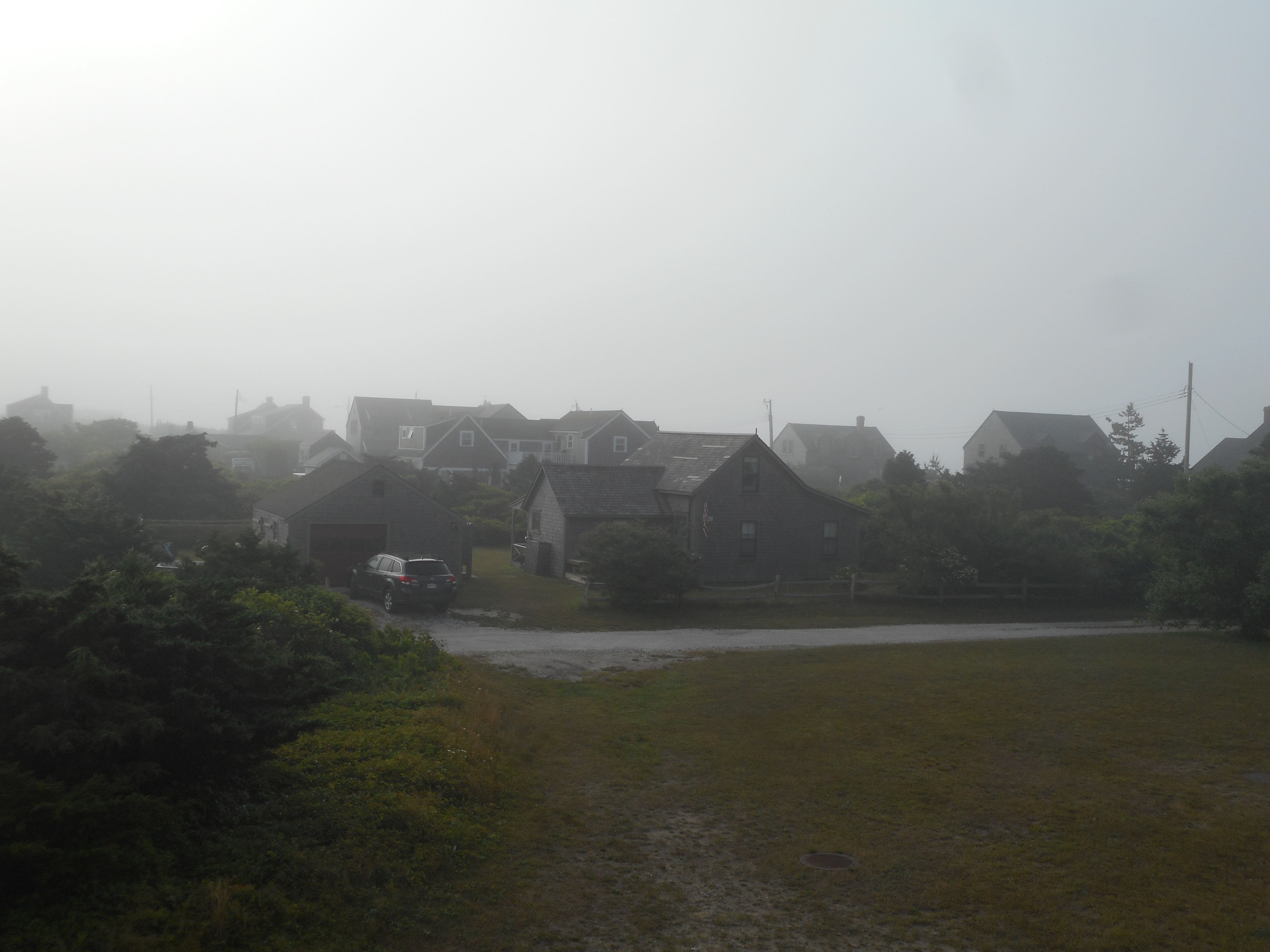
From mainland Massachusetts, Martha’s Vineyard is blatantly obvious in all but the foggiest weather. Just over three miles offshore from the nearest ferry port in Woods Hole, the ferry ride to the Vineyard clocks in at a rapid 45 minutes. Ferries come and go on a sub-hourly basis in the summers, and for just a few dollars you can secure your passage to the island. For a few dollars extra, you can even bring your own bicycle and take with you the finest mode of transportation for exploring the gems that Martha’s Vineyard has to offer. As I have visited the Vineyard three times by bicycle over the course of the past summer, I’d say I’m fairly familiar with the island. But at 88 square miles, the Vineyard will continue to surprise any frequent visitor.
Your trip to Martha’s Vineyard will most likely start in the port village of Vineyard Haven, as it occupies the most protected and accessible deep anchorage on the Vineyard. Vineyard Haven offers an excellent jumping off point for exploring the rest of the island. As the ferry is docking in the harbor, you will find yourself transported amidst a milieu of sailboats. Well known ships, like the Black Dog’s Shenandoah and Alabama tall ships make their anchorages here. Though Vineyard Haven is one of the three major population centers on the island, it is by far the smallest. Main Street is populated with bric-a-brac shops and fine eateries, but the commercial district of the town does not extend far from the harbor. Starting in Vineyard Haven provides a digestible foretaste of what’s to come on your next two city stops on the Vineyard.

The protected harbor at Vineyard Haven, a safe anchorage for sailboats
It’s time now to hop on your bike and head east along the bridged road that separates Vineyard Haven Harbor from Lagoon Pond. After a few miles of pedaling you will start to see massive Victorian houses appear; you are reaching the outskirts of Oak Bluffs, the Vineyard’s largest town. Oak Bluffs is distinct among Vineyard towns with its unique built environment and its lively culture as well. Formerly known as Cottage City, biking into Oak Bluffs is like riding into a storybook. The ornate ‘Gingerbread Houses’ are cladded with cookie-cutter ornamentation all painted in vibrant pastel shades. These grand old houses line an expansive ocean-side park laden with fountains, flowers, and park benches. Ocean Park, as it is known, is always comfortably busy with families strolling about and children flying kites. It gives off the whimsical aroma of an all-American town.

The prototypical All-American Ocean Park in Oak Bluffs
Before the Cottage City was built, groups of Methodists would flock to the Oak grove on the bluff to hold annual summer revival meetings in the early 1800’s. At first their camp colony consisted of a series of tents surrounding a larger meeting tent on the top of the hill. As the years went by, the Methodists gradually upgraded from simple tents to more and more elaborate buildings. Eventually, a large open-air tabernacle replaced the original meeting tent, and a village of Victorian cottages replaced the tents. The Gingerbread cottages then became a tourist attraction in their own right.
Methodists weren’t the only people attracted to Oak Bluffs. The island town has a long history of a community of color. The first blacks in Oak Bluffs were brought to America as slaves. By the 1700’s, freed blacks began moving to the town to seek work in the local fishing industry. The growing African-American population of the town then attracted black business owners to set up shop, adding to the growing community. In the late 19th and early 20th centuries, middle and upper-class African-American families sought out Oak Bluffs as a vacation destination. Unfortunately they didn’t have much other choice in their holiday destinations, as discriminatory laws in all other towns on the Vineyard prevented blacks from renting hotel rooms. Oak Bluffs was the only town that welcomed the presence of black vacationers, and to this day Oak Bluffs remains a destination for prominent families of African-American descent.
Beyond the sheer visual stimuli that is the gingerbread cottages of Oak Bluffs, the main commercial streets are always bustling with tourist traffic. Oak Bluffs was the only town on Martha’s Vineyard consciously planned for tourism, and the businesses on the main drags show it. Walking the streets of Oak Bluffs, one will encounter an unfathomable smattering of ice cream stores, candy shops, souvenir shops, and even a flashy arcade full of jazzy amusements and a carousel. In sharp contrast to the more tactfully hidden tourist nature of the other Vineyard towns, Oak Bluffs pretends to be nothing less than a destination for the masses.

A row of Oak Bluff’s whimsical ‘Gingerbread’ houses
After getting overstimulated in in Oak Bluffs, it is time to stretch the bicycling legs again and take the scenic bike route six miles southeast into the Vineyard’s other most populous town, Edgartown. The trail to Edgartown rides smack between the open ocean and Sengekontacket Pond. This stretch of sand and water is perhaps the most scenic ride on all the Vineyard. Along the path you will cross the American Legion Memorial Bridge, made famous from the movie set of Jaws. Take a quick breather and re-create the shark attack scene. It is also a popular pastime at the bridge to jump into the water. Just when you thought it was safe…

A pending shark attack scene from Jaws, with the famed bridge in the background
Continuing on into Edgartown, you will see more familiar Jaws scenery. The fictional town center of Amity Island was filmed here. The brick sidewalks and wooden buildings provide an olden-day feel to the town. Edgartown has a much more relaxed ambiance than Oak Bluffs. Its maze of streets are lined with shops and eateries which cater to the more refined traveler. Also in Edgartown, you can catch one of the world’s shortest car ferries. At a distance of 527 feet, the ‘Chappy Ferry’ to Chappaquiddick Island is nothing short of endearing. Endearing too is the island itself, lightly trafficked and abounding with beaches, forests, and the Mytoi Japanese Gardens. Continuing south out of Edgartown is another way to escape the bustle of the large towns; some of the Vineyard’s most popular beaches, South Beach and Katama Beach, lie just a short cycle south.

The classic look and feel of downtown Edgartown
After completing the trifecta of the major Martha’s Vineyard towns, it is time to get your bicycling legs in gear and make the long trek to the far western side of the island where the landscape becomes increasingly rural. Out of Edgartown, follow the bike path west. Soon enough, after passing through the outskirts of the town and a few boutique farms as well, you will reach the Manuel F. Correllus State Forest, a sizable patch of pitch pines and other scrubby trees that occupies the heart of the Vineyard. The bike path is far enough off the road and is adequately shaded by the trees so that it starts to feel rather isolated. After a good stretch of smooth riding, the bike path ends. To continue further west, it is time to venture onto the roads. Not to worry, though. Western Martha’s Vineyard takes on quite a different character than the populous tourist towns in the east, and not much vehicle traffic abounds on this side of the otherwise congested island.
To continue west at the end of the paved bike path, take your pick of either North, Middle, or South Roads. As you could probably infer from their names, these roads refer to their geographical location on the island. Once in the west, the hills on the Vineyard begin to get more pronounced. The forest, too, encroaches on the road; the continuous tree canopy is punctuated only by the occasional pastoral meadow. Old stone walls line the road and heirloom cattle graze in the pastures. After riding for a number of miles, you’ll eventually reach the small isolated village of Chilmark, whose claim to fame was a once-thriving deaf community with its own system of signing even before the advent of American Sign Language.
The pastoral landscape along Middle Road on the west side of the Vineyard
The village of Chilmark is a one-horse town, occupying little more than a road intersection with a few boutique shops and community buildings. Take a quick break on your bicycle to look around, but then head north again towards the ocean. A few miles later you’ll reach the quaint fishing village of Menemsha, an aged relic from the days when fishing was still a mainstay of the Vineyard. Take a stroll along the docks and watch the fishing boats offload their catch. Small weathered clapboard shacks line the Menemsha basin and fishermen peddle their wares to off-the-beaten-path tourists. It was this village that served as the home of the salty shark hunter Quint from Jaws. As a special bonus for cyclists only, Menemsha offers the special treat of a bike-only ferry to traverse the stones-throw distance across the entrance of Memensha Pond. After seeing enough fish in the village, take the bike ferry and enjoy the short water transit.

Menemsha, a quite charming active fishing village on the fringe of the island
On the other side of the bike ferry, you’ll find yourself in a land of sand and hills directly lining the ocean. Pause for a moment and think about the eastern end of the Vineyard just fifteen miles back—this has become a vastly different world. Rather than opulent vacation compounds, the houses here are beaten and weathered, laying spattered in the woods like an organic outgrowth of trees. It is here where you will enter into the Wampanoag Aquinnah lands, lands that are still held by the original peoples of the Vineyard. Also, at this point you should notice that you are biking uphill; this means that the spectacular Gay Head Cliffs are quickly approaching.
Once you spot the Gay Head Lighthouse in the distance you will know that you are near the end of the island. At its westernmost point, known as Gay Head, Martha’s Vineyard abruptly drops into the ocean at the Gay Head Cliffs. These cliffs are made up of clay, a dissimilar material to the glacially deposited till that composes the rest of the Vineyard. As a geological phenomenon, layers and layers of the Gay Head clay—former seafloor sediment—were pushed upwards by the weight of the glacial moraine formed during the last ice age. Over time, the ocean has been reclaiming this above-water material and has formed the cliffs via erosion. Wampanoag legend holds that the god Moshup, a benevolent provider, lives in the cliffs. The red stains on the cliffs are from the blood of the whales that Moshup eats, and the black is the soot from the fires that Moshup cooks over. The Wampanoag peoples hold these cliffs and their mud sacred, and as a visitor it is easy to see why. This secluded end of the island is a special place, worthy of admiration. From the overlook of the cliffs, it is an easy enough walk down to Moshup Beach, where one can stroll along the sandy beaches under the towering cliffs. After such a whirlwind tour of the Vineyard, there really is no better ending.

The Gay Head Lighthouse standing tall over the colorful cliffs

Nantucket, the Faraway Land
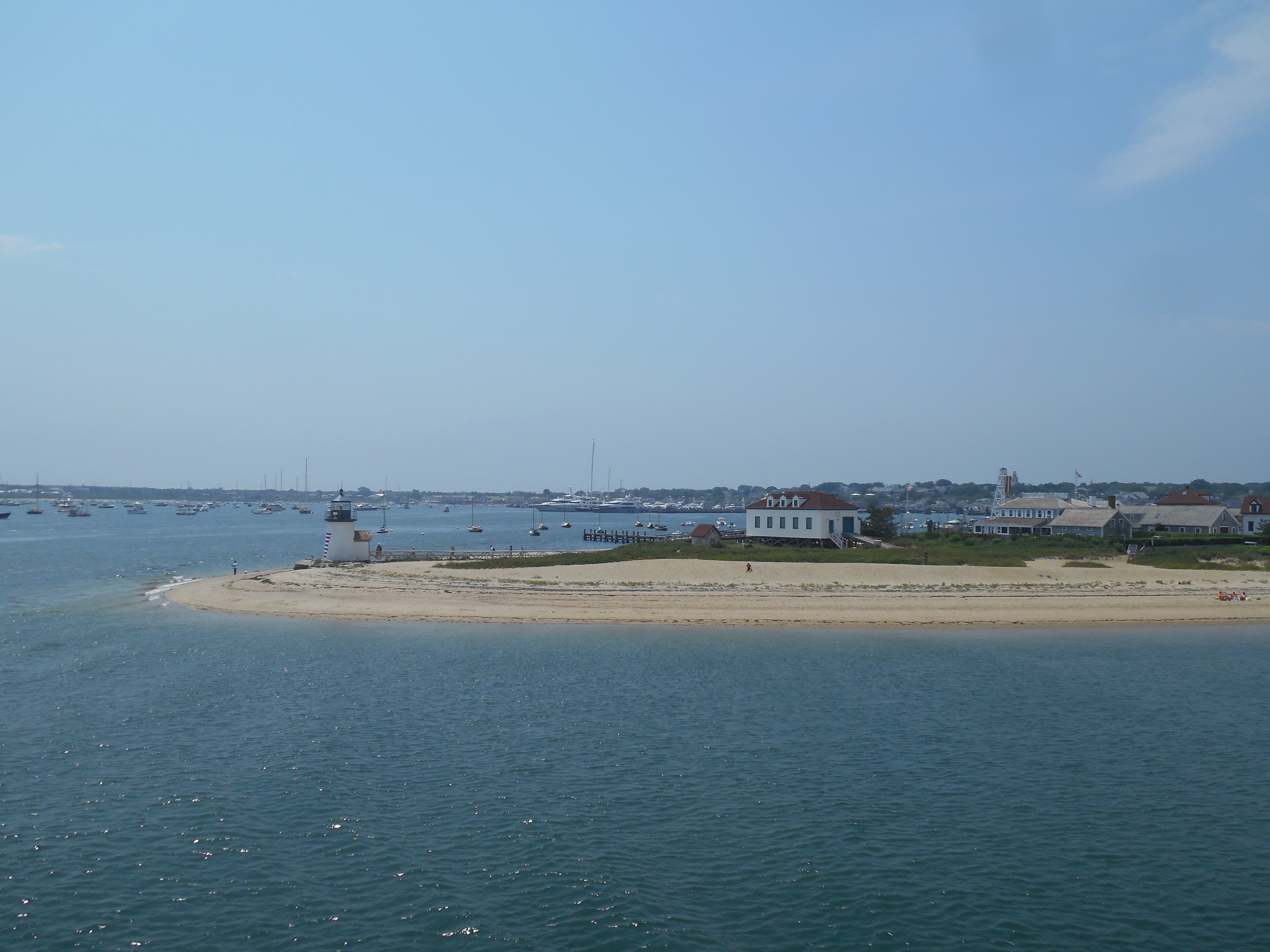
Rounding Brant Point at the shallow entrance to Nantucket Harbor
Thirty miles off the Northeastern seaboard of America lies a distant land, one that is removed to both time and mainstream American culture. On a clear day you can squint your eyes and barely make out the remote island over the horizon. The Wampanoag people, the ones who first inhabited these lands, named it ‘natockete’—the Faraway Land. Today, the island of Nantucket is easily accessible yet remains isolated by distance and culture; it remains the proverbial faraway land.
To get to Nantucket requires intention; no one ends up there on accident. The ferry ride from the mainland itself promotes the isolation, requiring over two hours to traverse the expansive Nantucket Sound. This distance and isolation has produced the distinct identity of the Nantucketer; native Nantucketers, when they seldom do go to the mainland, feel so removed from it that they refer to it as ‘going to America’. The island’s 48 square miles makes it insignificant in area, but the island makes up for its lack of size with its depth of character. Charming and quaint with its cobblestoned streets and rows of simple clapboard shanties, the Nantucket of today appears as an island forgotten in time. Yet, underneath this unassuming appearance lies a cosmopolitan society fueled by a multi-billion dollar tourism and real estate industry. Retreatants from all across the globe call this island a home, either permanently or seasonally. Yet, the island has resisted the global corporate commercialization seen on the mainland. There are no fast food restaurants here, and no superstores. The businesses and development on the island are unique and independent as the island and her inhabitants themselves.

Nantucket town, with it’s modest buildings sheltered by street trees. The most dominant feature of the skyline is the Quaker Meetinghouse. Nantucket’s many wharves stretch into the harbor.

Main Street Nantucket: rustic and cobblestoned, yet modern and full of traffic.
In terms of natural resources, Nantucket itself has little to offer. The island is a relic of the last ice age, merely a pile of sand in the ocean dumped by a glacier some 20,000 years ago and continually sculpted away by the sea. Incessantly battered by the ocean, the natural environment of the island remains fragile and the blanket of ocean fog that often shrouds Nantucket has earned her the nickname ‘Grey Lady of the Sea’. Nevertheless, the cryptic island still supported much life, including a complex human culture. For thousands of years, the Wampanoag people lived sustainably on the island in small groups called sachems. Five to six thousand years ago, rising tides from glacial meltwater cut off Nantucket from Cape Cod for good, creating the isolation needed for the distinct cultural identity of the original Nantucketers to develop.
European settlers to the Massachusetts Colony, off-put by the island’s isolation and lack of resources, initially passed over the Grey Lady. Eventually, however, the island’s isolation proved an allure as well, and the earliest English settlers came in 1641 to seek a reprieve from economic and social oppression on the mainland. Those early settlers tried subsistence farming and grazing like they had known in their home country, but agriculture and livestock grazing proved unsustainable and dramatically changed Nantucket forever. The native vegetation was stripped from the landscape, and the already poor soil was lost. Looking to maintain their fragile existence, these early Nantucketers turned to the sea for their salvation.

A rooftop view of Nantucket town’s skyline
And the sea, though violent as it may be to the island itself, provided generously for the settlers of Nantucket. The coastal waters of the Atlantic were rich in fish resources, in turn supporting an abundance of whales. The ongoing industrial revolution created an insatiable demand for whale oil products, and Nantucket capitalized on its nautical location. Nantucket’s proximity to the sea, instead of the isolation due to it, provided an advantage as Nantucket reinvented itself as a whaling port. With the seas as the roads and the primary mode of transportation being sailing vessel in those days, even isolated settlements on the mainland were effectively islands at that time; being a physical island was not much more of a barrier. Though poor in natural resources, Nantucket could easily ship in whatever supplies they needed from the mainland—lumber, food, labor—all financed by the profits of the whale industry. By the mid-1700’s, Nantucket was a booming city with a population surpassing 8,000, as well as being the nationwide leader in whaling. Though awash in wealth from the whaling industry, the Quaker values of the Nantucket settlers shunned displays of opulence and prosperity. Instead, Nantucketers lived simply and constructed economical dwellings for themselves in a society subservient to both God and the whales. Astute businessmen, earnings from whaling were re-invested directly into the industry.
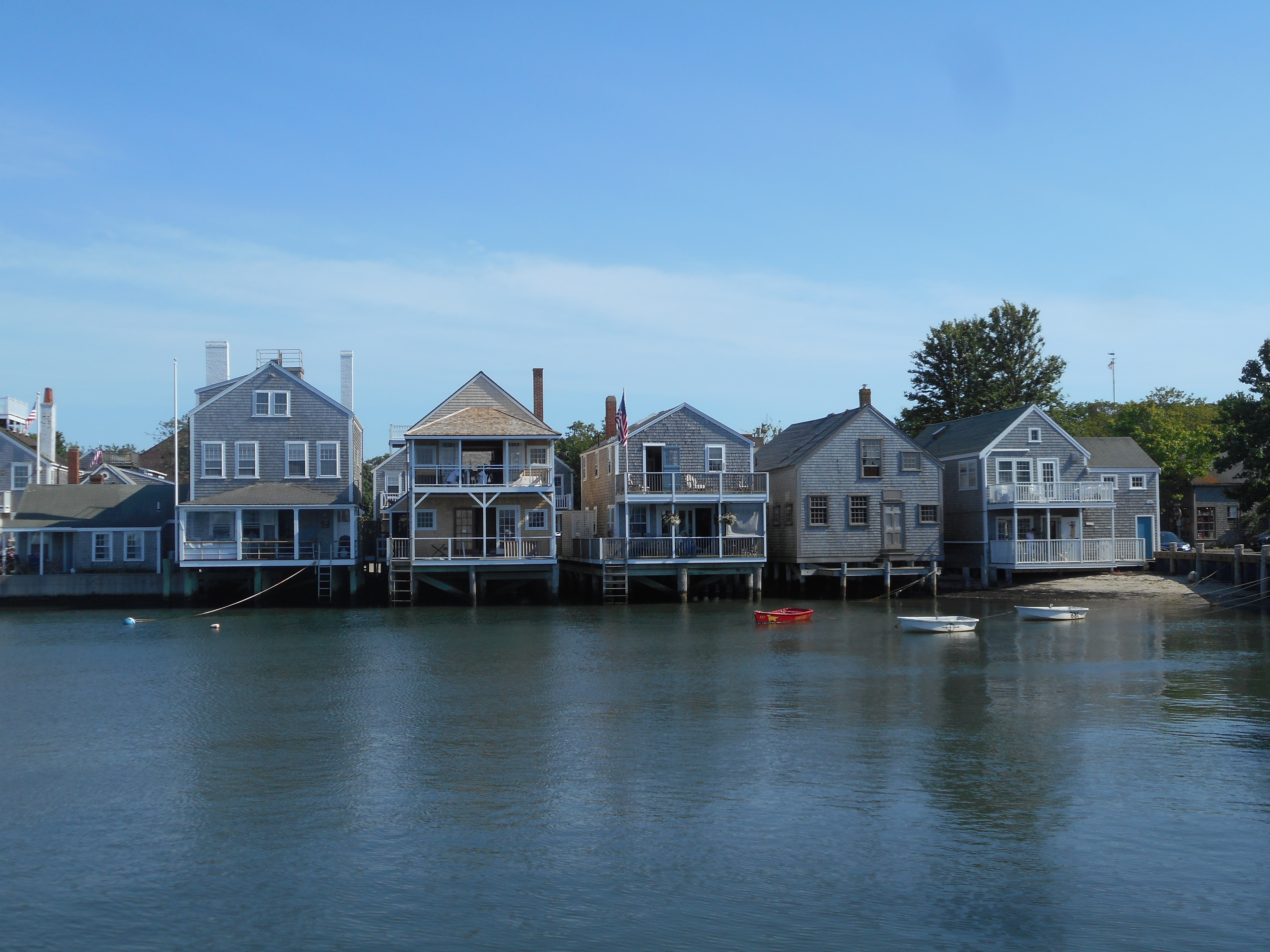
Waterfront Property: modest houses built upon Old North Wharf in Nantucket Harbor

The Old Mill: built in 1746 as a way to grind corn meal for provisioning ships
Eventually, Nantucket’s isolation began to lead to the demise of the island community. The success and monopoly of whaling for Nantucketers meant that whaling was the only industry in town. Serving as a whaler was a rite of passage for the islanders, and an insular culture around whaling practices developed. Nantucket whalers were distrustful of technological advances and nautical knowledge from others off the island, even as the traditional whaling industry as they knew began to decline. The overhunting of whales in Nantucket’s backyard, the Atlantic, led to the development of the Pacific whale fishery. To accommodate for longer voyages, the whaleships grew larger and more technologically advanced, and the shallow sandbar at the entrance of Nantucket Harbor eventually prevented these larger boats from docking in the Harbor. As a symbolic tragedy of the demise of Nantucket whaling, in 1820 the Nantucket whaleship Essex was sunk in the Pacific by a sperm whale—the gruesome tragedy that would inspire the novel Moby Dick. By the mid-1800’s, the whaling industry in Nantucket was in its death throes. Nantucketers stubbornly continued whaling with diminishing returns while the deeper mainland harbor in New Bedford, Massachusetts, with access to rail transportation became deeply profitable. Nantucket’s status as an island had once again become a liability. The last whaleship sailed out of Nantucket in 1845. Then, in 1846, a fire on Nantucket destroyed 40 acres of the town. A great depression fell over the island. With little economic opportunity left, the people of Nantucket began a mass exodus. The island’s population plummeted to under a third of its whaling peak.

The red house was owned by whaling captain George Pollard, the captain of the ill-fated Essex voyage. Though they occupied the highest rank on the island, captains nevertheless built simple dwellings for themselves.
Nantucket Island would spend the next many decades unadorned and steeping in its isolation. Not until the turn of the 20th century did it see signs of revival as an island. In the roaring decades of the early 1900’s, artists and actors from the mainland began to turn to Nantucket for summer retreats. Lured by its quaint charm and rustic beauty, celebrities and wealthy businessmen alike sought refuge on the island. By the 1950’s Nantucket had become a popular enough retreat that developers saw the economic potential of a resort community. However, fearing the loss of the town’s character, great efforts were made to preserve the historic architecture and rustic charm of the island that had attracted vacationers there in the first place. Nantucketers, ever resistant of trends on the mainland, fought for the preservation of their island’s history and culture, resisting the post-WWII re-development and commercialization that was ongoing on the mainland and neighboring rival Martha’s Vineyard as well. Their efforts preserved the downtown core of Nantucket town and its outskirts, making it today the best-preserved pre-civil war era town in America.
Nantucket town today remains a maze of narrow streets densely populated with simple clapboard houses and sheltered by street trees. Main Street—the main commercial drag—is wide and cobblestoned, lined by old brick buildings, and leads straight down to Straight Wharf—one of the town’s many links to the sea. The sea is still the lifeblood of this island community, only today the harbor is frequented more by pleasure craft than by whaleboats. Outside of Nantucket town, the island is rural and rustic. Scraggly forests, instead of cookie-cutter suburbs, fill the isolated interior. On the fringes of the island, quaint shanty villages like ‘Sconset give off the forgotten seaside town aura. Today, more than 10,000 people call Nantucket home year-round, a number surpassing even the zenith of the whaling-era population. Though the island’s residents swell to over 50,000 in the brief summer months, the pace of life feels relaxed nonetheless.
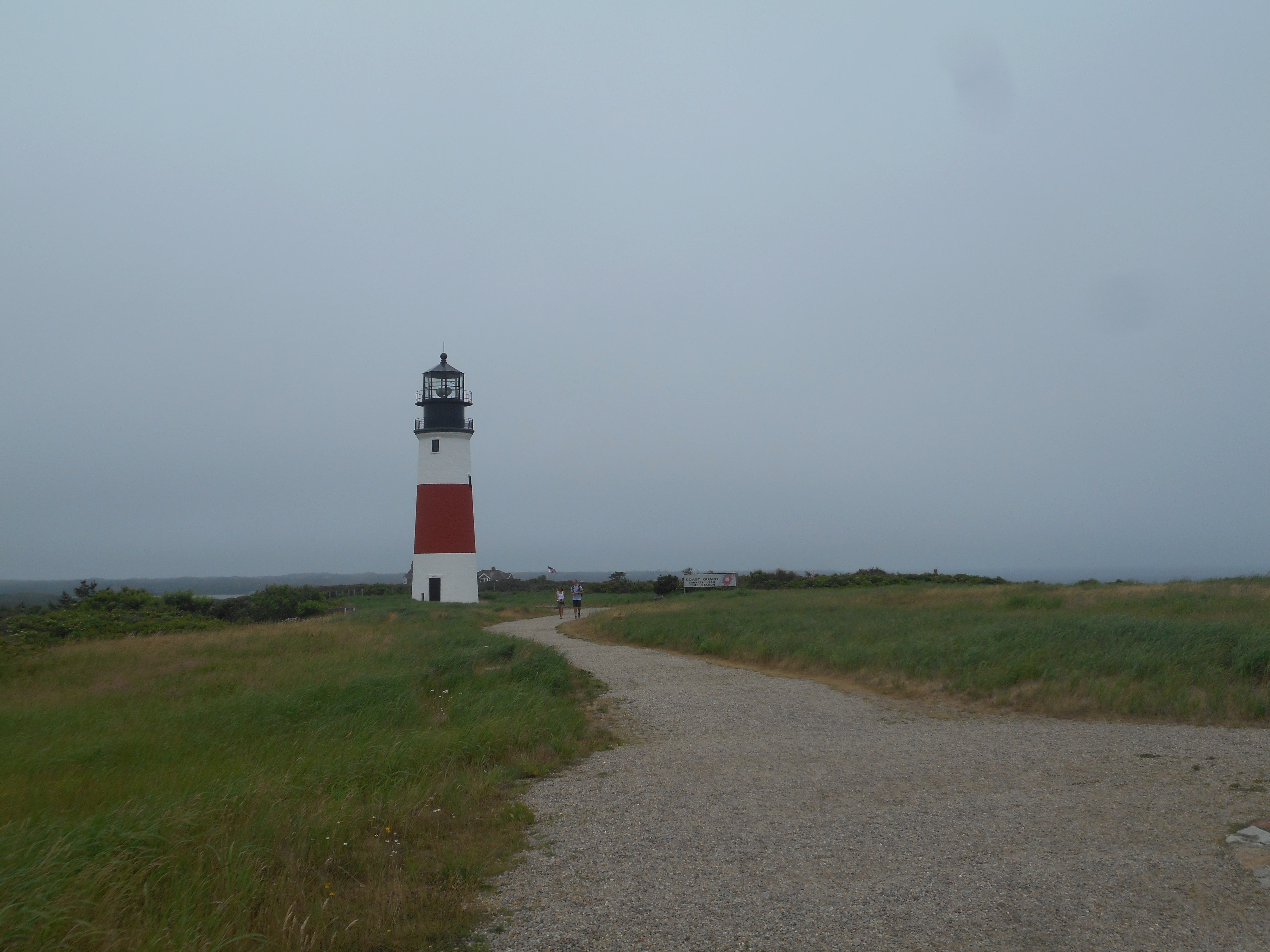
On the easternmost edge of Nantucket Island is the Sankaty Head Lighthouse. The waves continually erode away the island, forcing the relocation of the lighthouse in 1997.
I recently spent four days on Nantucket Island, exploring the island’s corners by bike. On a small island, there is nothing quite like exploration by bicycle, taking the slow route to the island’s fringes. Being on Nantucket, something inexpressible grips you. It’s a place you’ve been that’s like no other. Something on the island beckons you, drawing you in. Is it the salty air, the foggy mornings? Is it the predominance of the ocean, with the waves and the surf? Is it that the pace of life seems slower here? Unlike its rival island Martha’s Vineyard, there is not much human entertainment found on the island. Yet, in my time ashore, I found the days to be packed full of sights and sounds. The ocean beaches, the stars at night, they are the things that filled the time in all their gloriousness. Those four days seemed to stretch into an eternity yet flew by all too quickly.
Many people visit Nantucket each year, from all corners of the globe. The island—its mystique and aura—seems to leave an irreversible impression. Something about time spent on the island seems of a different caliber. For some, decades may pass between visits, yet Nantucket remains as a place near the surface of memory. The island always beckons you back. When you return, the enchantment of the island overpowers you once again. Nantucket whispers “forget about the mainland. Relax. Enjoy yourself. Linger for a spell, if only for this short while.”
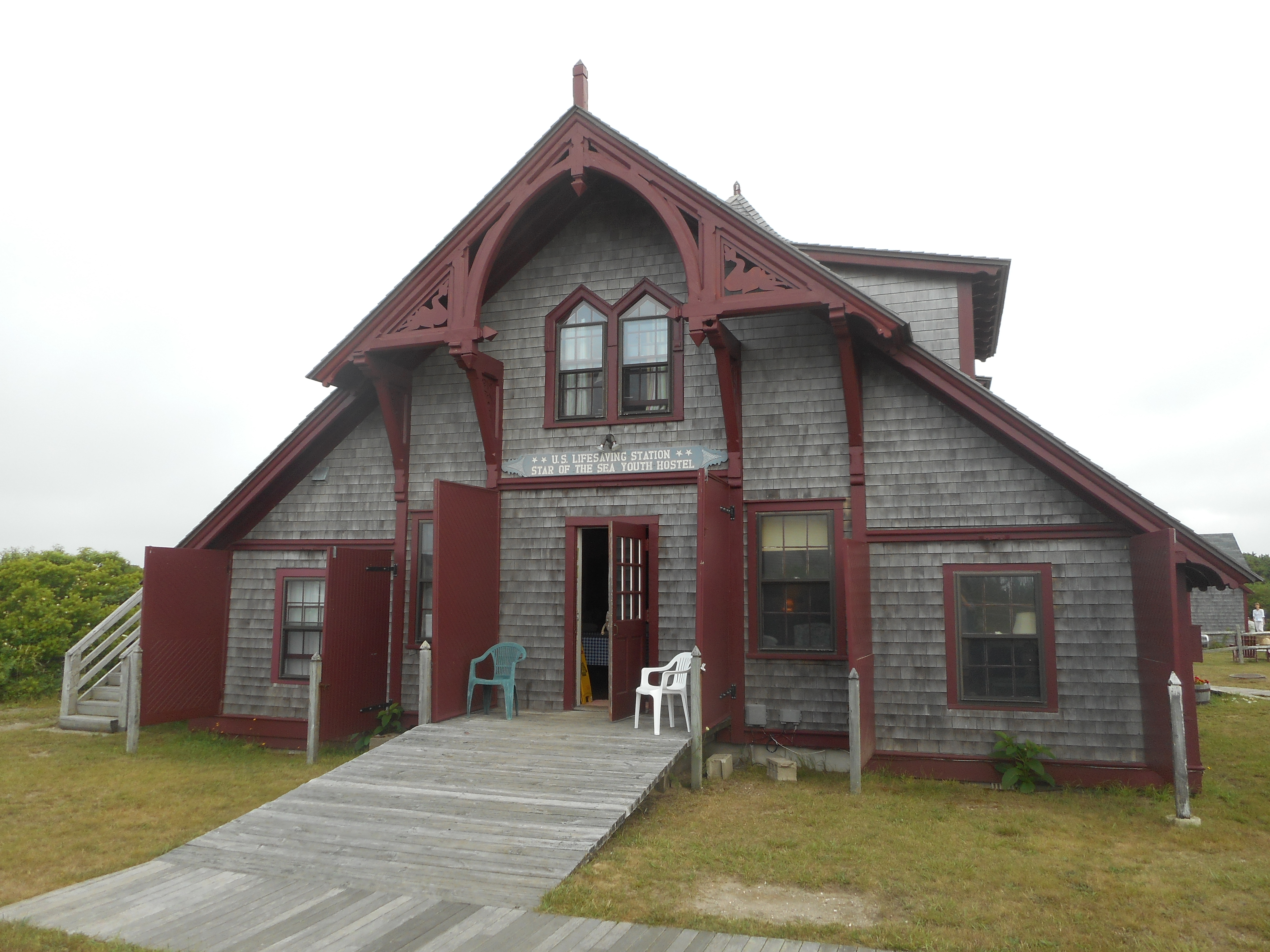
The former Surf Lifesaving Station in Surfside. No longer used for saving lives, the station has been converted into a youth hostel.
The southernmost settlement on Nantucket, the small burg of Surfside, often covered in the misty morning ocean fog that shrouds the Grey Lady

1,234.63 Miles Later
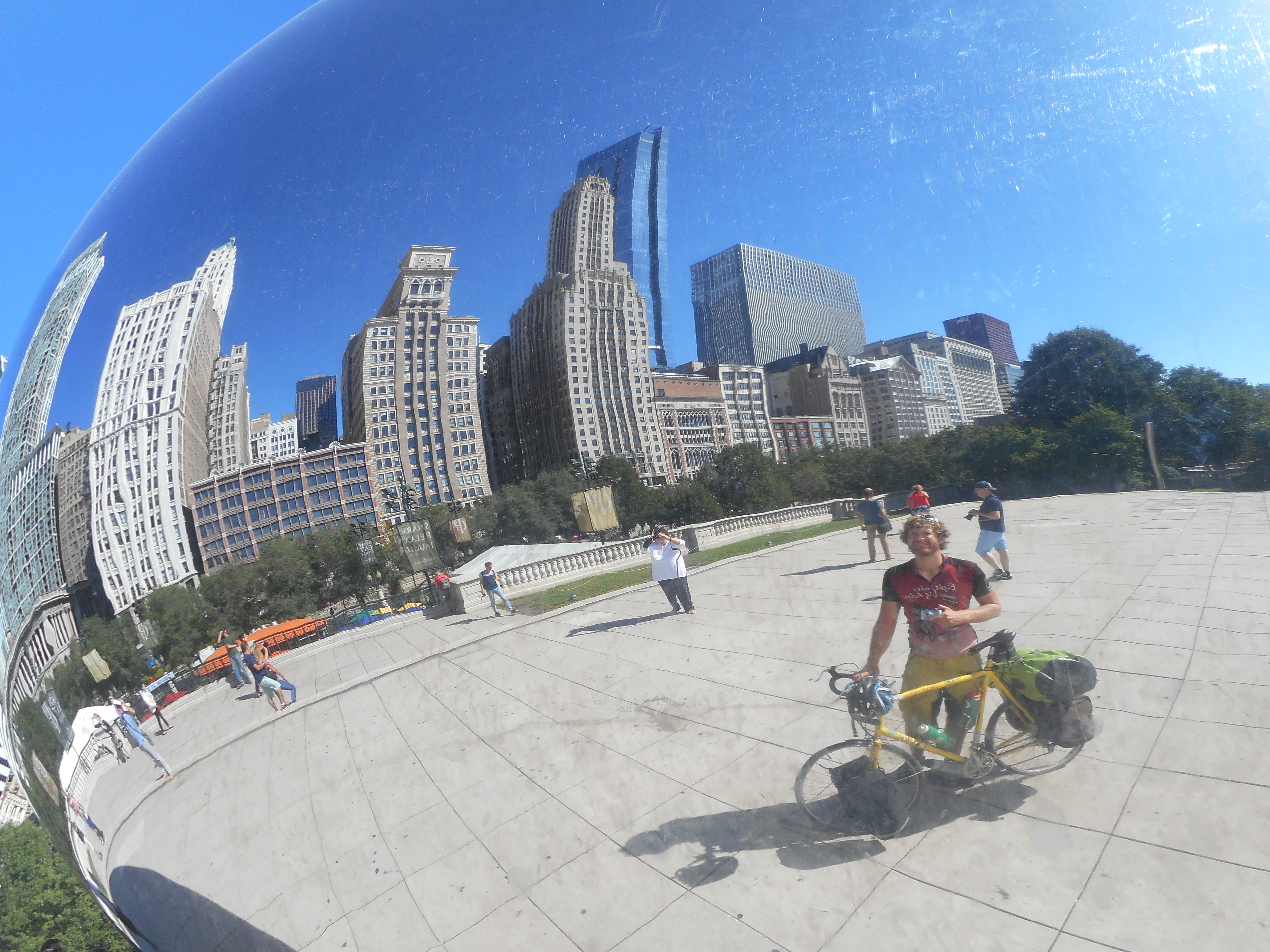
Stopping in Chicago along the way
My bicycle hobbled over the pavement for the final stretch, rims wobbling, bearings creaking at every turn. One thousand miles of loaded travel puts a great deal of wear on a bicycle. Tires bald, brakes worn down, dozens of new scratches in the bright yellow paint. I rode with baited breath my final day, hoping that my emergency tube patch job would hold after blowing my last spare on a particularly aggressive Indiana pothole the night before. Braking for the last time on my parent’s uphill driveway, I came to my final stop. 19 days. 1,234.63 miles.
It was a rather uneventful end for such a long trip. Arriving at my destination felt no more different than returning from a short evening ride. The cheering spectators, the paparazzi that I’d expected were absent. I had thought that my trip would deserve an epic fanfare, a grandiose welcome after such a long physical exertion. What I got instead was a simple welcome home from my parents. Soon enough thoughts of riding drifted away from my mind as I integrated myself into my parent’s nightly television routine. Coming back from three weeks of biking felt little different that coming back from a day at the office
I ended up cutting my trip short by a day. Camping in Indiana on what would be my final night, I made the decision to push through and make it all the way to my destination instead. To myself I had already proven my capability to endure the journey; all I needed to do was complete the trip. Instead of leisure and sightseeing on my final day, I just put my head down and rode. Peddle after peddle, mile after mile kept adding up until I amassed 113 in one day. With goal in site, no time to relax—just time to ride.
The most intense feeling I had on my final push was one of relief. Biking north out of Michigan City, I caught glance of the giant blue “Welcome to Pure Michigan” road sign. After so long away, finally back in my home state. A lump grew in my throat and my eyes teared up as I crossed the state border.

Overcome by sentiment at reaching the state line
Later on, coming into the outskirts of Holland, that same emotional relief came over me; ‘I recognize this place now’, I thought to myself, ‘I know where I am. From here it’s only 4 miles, 3 miles, 2 miles…’ To the onlookers curious at why the overburdened cyclist was sobbing, there is only one simple response:
I had made it
What difference does it make now that such an arduous trek is behind me? Already the memories of the toil are fading. The afterglow was short-lived. A few hours after arrival I found myself showered, rested, and unpacked from the journey. No time to bask in remembrance, and only a few people to recount the adventure for. Instead I had pressing work to prepare for my upcoming job.
But already I feel nostalgia for the journey. The lactic acid has since drained from my legs and I’ve forgotten how sore I felt on the expedition. Rosy retrospection smiles kindly upon the difficulties, and I find myself yearning for more. A journey of one thousand miles, and I had chosen to stop in the middle of America when more road lay yet before me.
After such a long journey, after such a feeling of relief when I finally made my destination and could rest, I realized one thing:
I could have still kept biking on.

View from the Saddle
Fast enough to get places, but slow enough to see them–that’s what I enjoy so much about travel by bicycle. The saddle may not be comfortable, but the views provide the reward. Traveling over 800 miles in 11 days has heightened my geographical senses. Slowly peddling a great distance, one gets to play landscape detective: what’s changing and why?
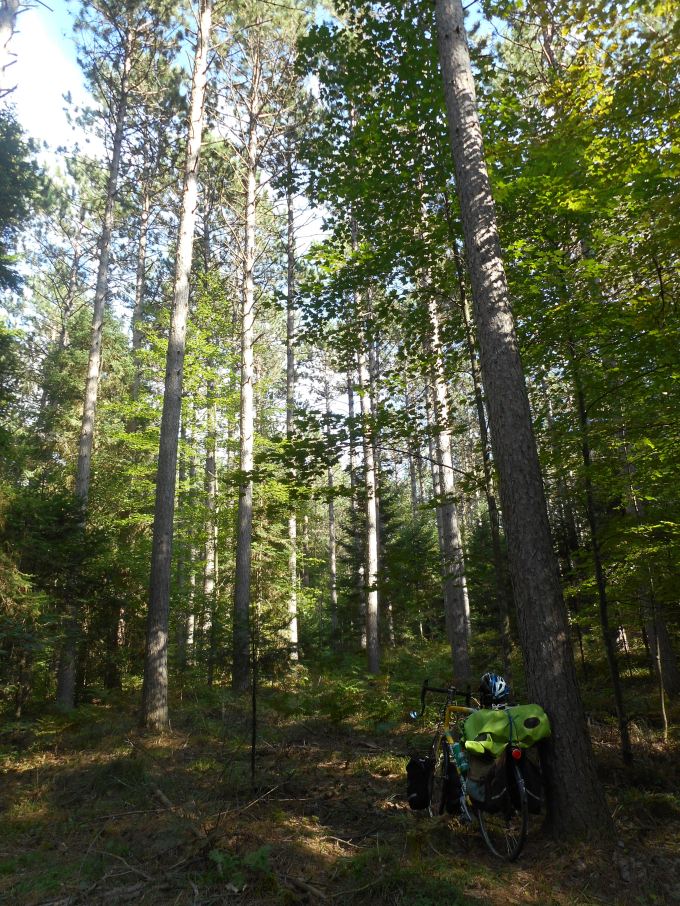
Guerrilla camping in the majestic white pine forests of northern Wisconsin
The northern hardwood forests began to become infiltrated by beech and maple, warmer clime species from more fertile soils found further south. Farm country spontaneously erupted from the sylvan wilderness. Along the lakeshore, farmland eventually gave way to industrial cities.
The landscape shifts imperceptibly, but gradually, determinants of the physical and cultural environment. Any given day I could find myself peddling down a rural country road or meandering on a dirt track through a mature forest.

Traveling through a forested corridor along the Eagle River Trail in northern Wisconsin

Following the route of the railroad on one of Wisconsin’s many rail-to-trail paths, the Glacial Drumlin State Trail linking Milwaukee to Madison
The weather changes also, with it bringing different moods to the landscape. Bright sunny days can make the terrain warm and inviting; cool, cloudy days present a somber melancholy air. Staying alert to the changing light environment rewards the onlooker with a multiplicity of panoramas, an ever-evolving sensory scene.

A diversity of clouds fill the sky above Green Bay
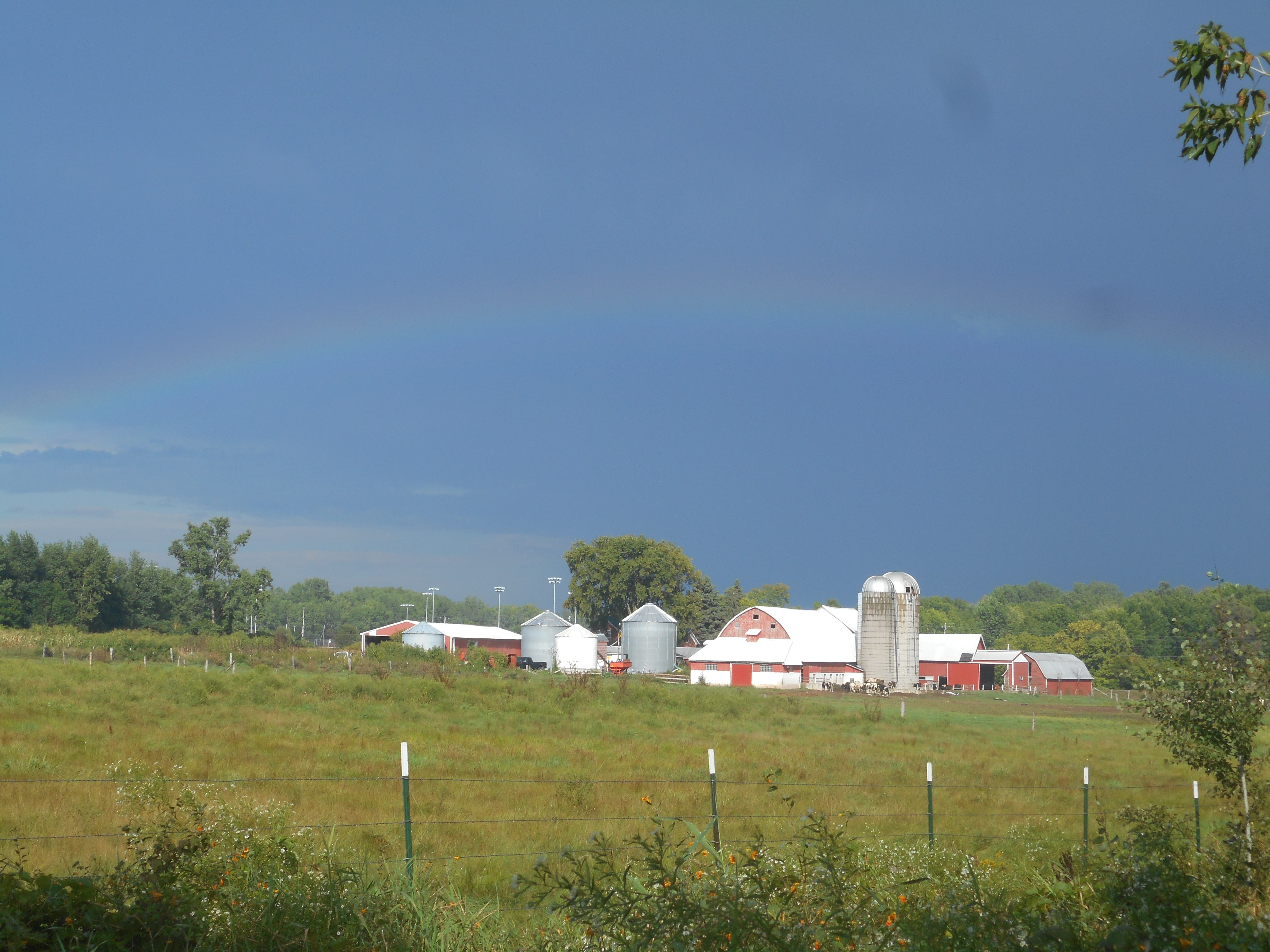
The rainbow after the storm: rural Wisconsin after a thunder shower passes
The culture shifts along with the landscape it inhabits. Forest land gives way to farm country. Tourist towns and sleepy hamlets lie tucked under the lakeside bluffs on the Door County Peninsula. Large industrial cities occupy important harbors on the Michigan lakeshore. Out in the hinterlands, a lone water tower on the horizon signals an approaching town.
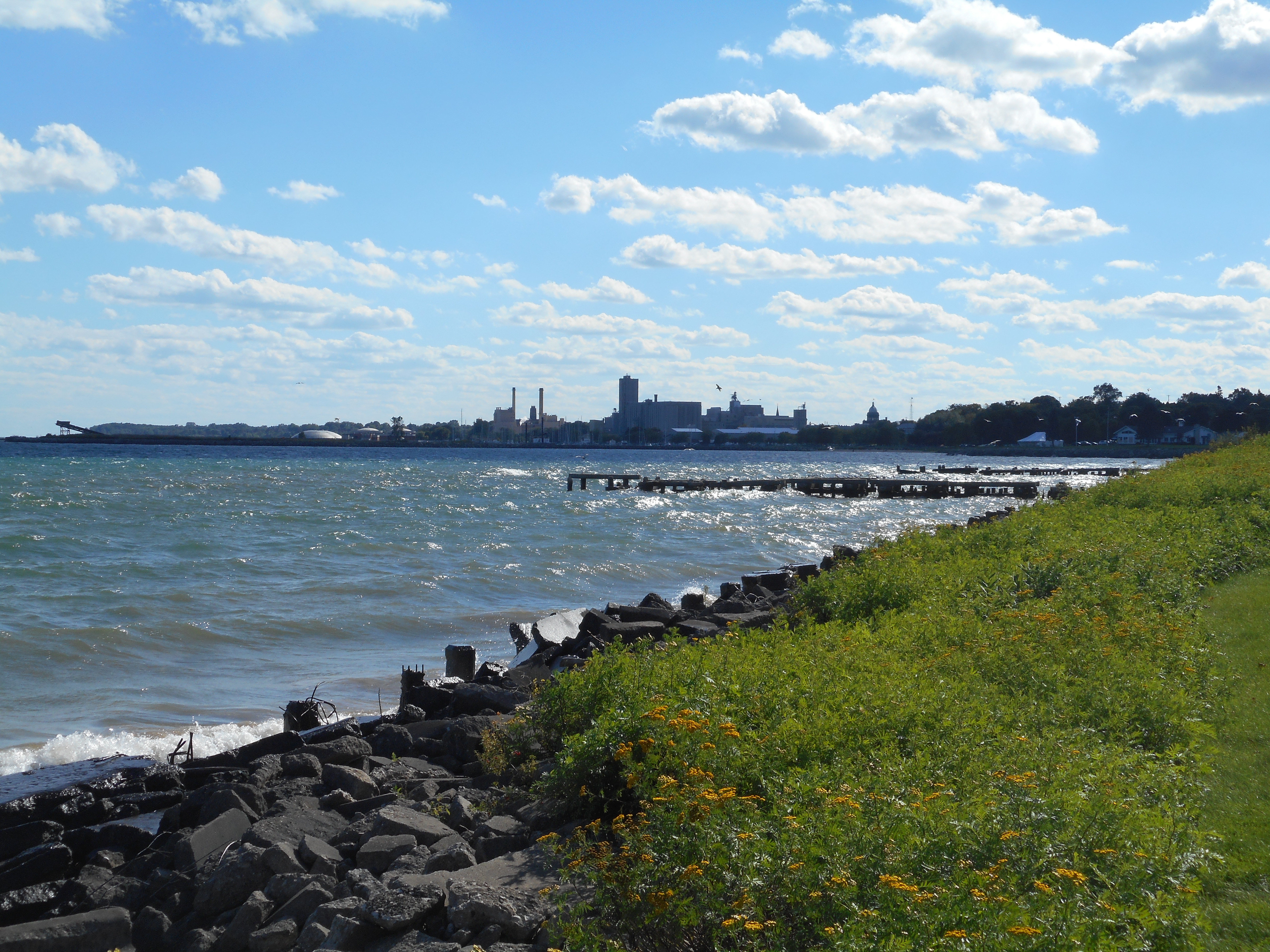
Riding the Mariners Trail into industrial Manitowoc, Wisconsin
Along the way I pass through areas of local history and interest. Where did the inhabitants of Oostburg come from? Why is there a village of Wales in the Wisconsin countryside? Roadside markers provide insight on the history of each small settlement. By car, it’s an inconvenience to stop and learn; by bike, it’s a welcome break from pedaling. Roadside harvest stalls showcase the seasonal agriculture and nourish the famished biker. A destination of interest, no matter how modest, is worth stopping along the way.

The spiral staircase leading up the Cana Island Lighthouse in Door County

View from the top: Potawatomi State Park’s 75-foot tall observation tower
Beautiful nature abounds if you go out and seek it. Along the tracks and trails, nature displays her splendor. These places call out, beckon you to come close and linger.
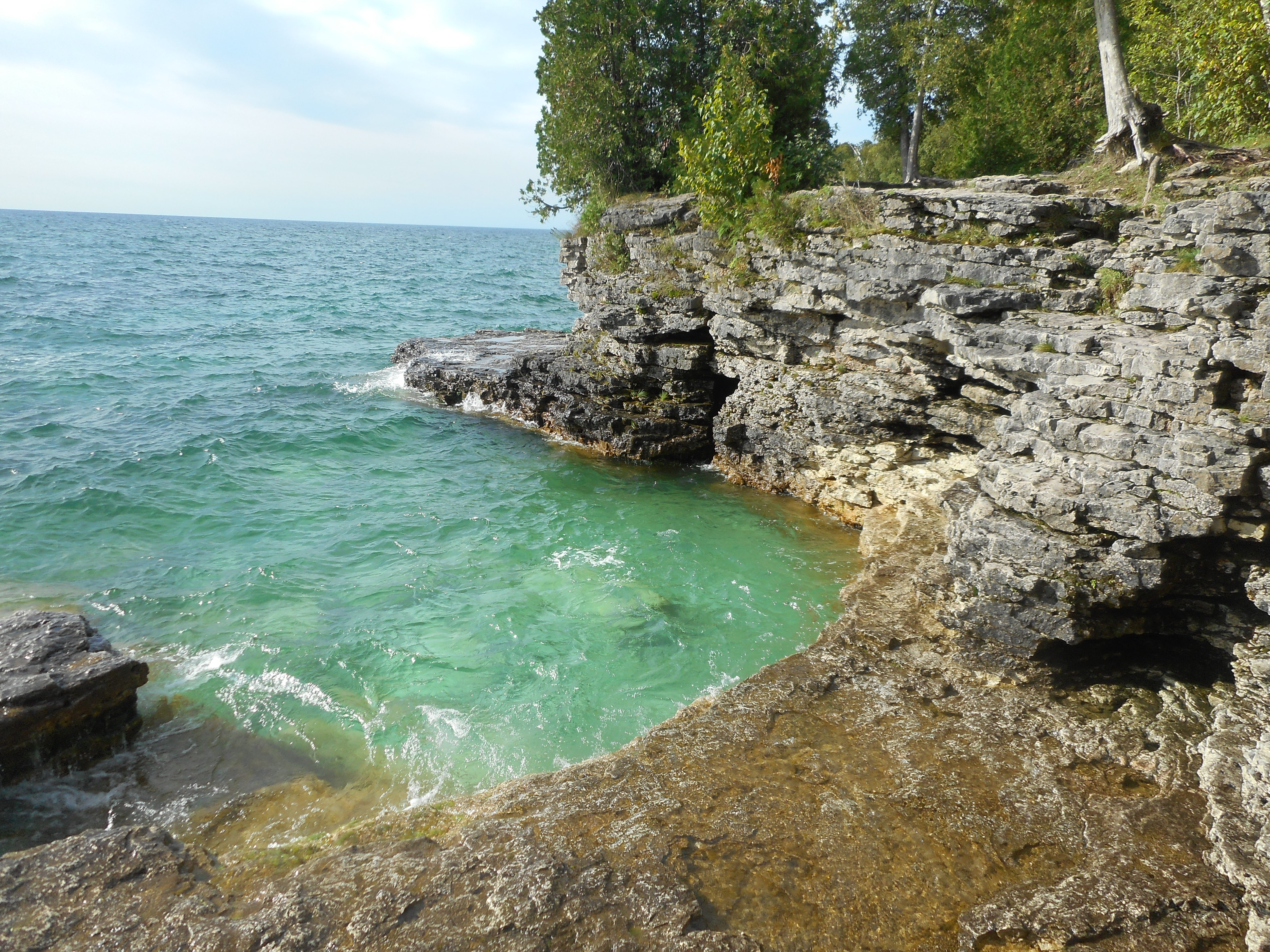
Dolomitic Limestone formations at Cave Point County Park, Door County

Stopping for a swim break along a sandy Lake Michigan beach–Point Park State Forest
The long journey is never about reaching the destination; it is about the process of discovery along the way.
 Journey of 1,000 Miles")
The (Bicycle) Journey of 1,000 Miles

Ready to go at the starting point
p
“Nothing compares to the simple pleasure of riding a bike” John F. Kennedy
p
Confucius may have wisely remarked that a journey of a thousand miles begins with a single step, but since the bicycle wasn’t invented until 2,000 years after his time, he never got to say that the bicycle journey of one thousand miles begins with a single pedal. Also dealing with one-thousand mile journeys, another hero of mine, John Muir, began his period of long wanderings as a 20-something with a 1,000 mile walk from Indiana to the Gulf Coast. So it only seemed fitting that I should embark on a thousand-mile journey myself—1,000 miles of adventure and exploration via the bicycle.
I could write on and on about how my upcoming bike ride is a promotion of bikeable communities and alternative forms of transportation. I could posit this venture as a political statement about our oil-dependent and vehicle-oriented transportation system. I could say I’m doing this ride for all the health benefits of biking. I could even pass this journey off as a slower-paced trip along the backroads of rural America, where I can see my own country in a new light and get to meet authentic everyday Americans.
But really, I’m going on this journey because I really like to ride my bicycle. Well, and that I don’t have a car—or enough money to justify a plane ticket for that matter. And somehow I need to get back to my hometown from my summer camp job in rural northern Wisconsin.
The idea of biking back home after camp had always been at the back of my mind, even before arriving at my summer job. That’s the reason why I made sure to ship my bike to Wisconsin and only arranged for a one-way ticket to camp. Having nothing lined up after camp (well, initially, that is!), I found myself in the predicament where I had ample time to travel, no hurry to be anywhere, little money for gas, and a great desire to really travel. What better to fit my circumstances than a bike trip.
I have frequently entertained the idea of a long trek by bicycle, but have never yet risen to the occasion. Sure, I am the veteran of a handful of overnight bike camping trips, and in the summer of 2011 I completed a three day/two night bike ride of 200 miles in New England. But the really long journeys have remained little more than fantasy for me. I have select group of friends who I routinely discuss long bicycle adventures with—be they cycles across America or a bicycle trek of Europe. Will a successful regional gig be a testing of the pavement for something greater down the line…?
On this journey I will be traveling with my constant companion, noble steed, and packhorse, my (still unnamed) bicycle. Me and my bright yellow bike have been together since 2010, and she’s a 1990’s model Cannondale that I bought second-hand. She’s not a fancy bike or an expensive bike, but she’s a sturdy bike who can carry a load and take a beating. Weighing in at 36 pounds with accessories, she’s an-aluminum frame touring bike with all the features. Fitted out with my load of camping supplies, clothes, rations, entertainment, and other odds and ends I wanted to bring, the total weight of my outfit rises to 78 pounds. I could have packed much lighter, but then again extra weight on a bicycle isn’t noticed too much.
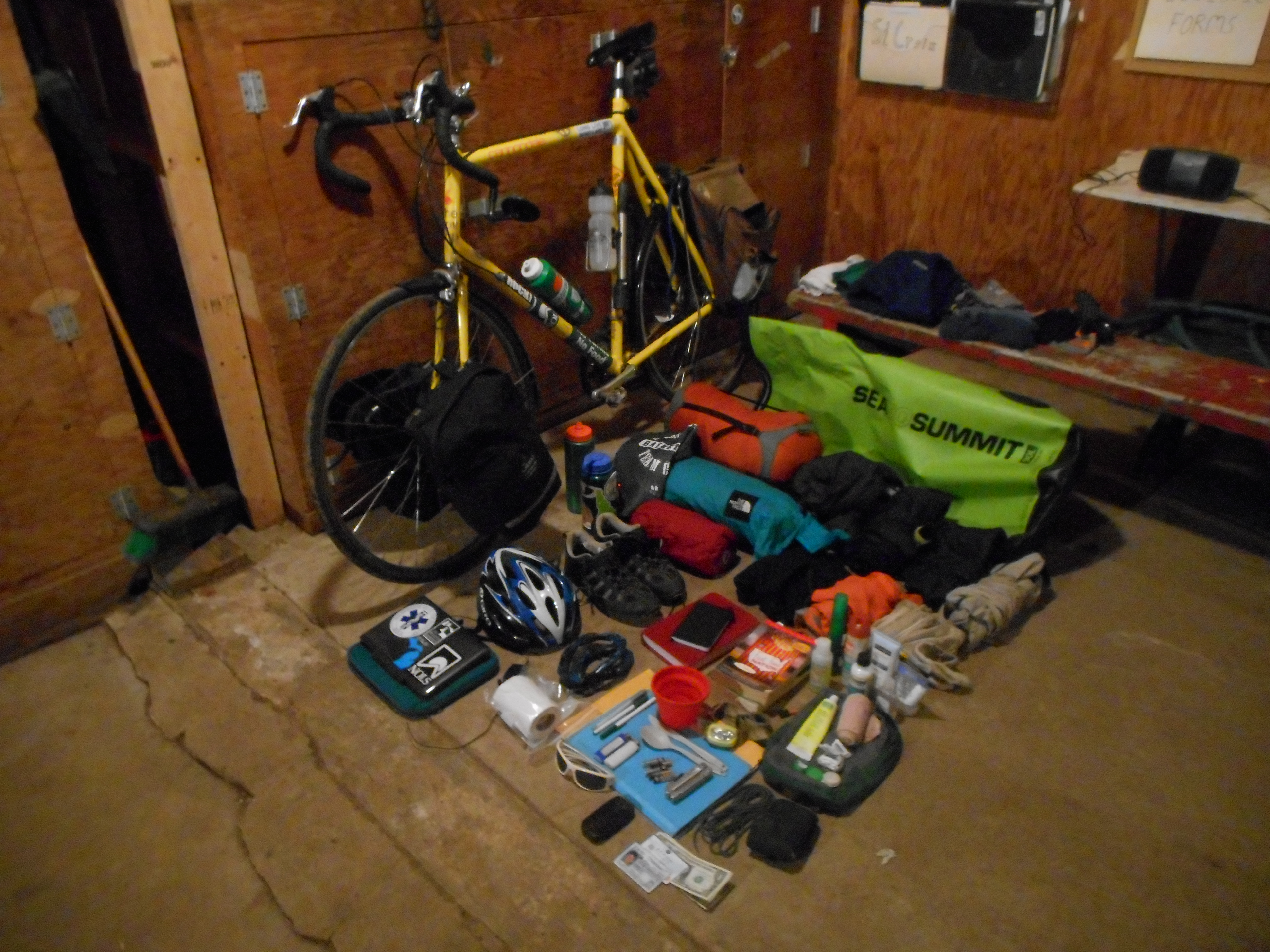
Gearing up for the trip with everything I’m bringing with me
On average I’ll be riding between 50 and 60 miles per day. From start to finish I’ll take 20 days, with a few layover days scattered throughout for rest and recreation. Although I haven’t done as much training for my ride as I hoped, I feel more than ready. Long-distance biking is a challenge of endurance, not strength. So much of endurance is the mental resolve to continue.
If the point of the journey was just to get myself back home, I could do it in under 500 miles (although that would necessitate a ferry across Lake Michigan). But I’m taking a meandering route, stopping by some special places and enhancing the trip by visiting friends, which increases my projected distance to over 1,100 miles. I’ll try and post regular updates as I go along, but here is a general overview of my itinerary:

September 3: Leave North Star Camp and start my bicycle journey
September 8-9: Biking tour of Wisconsin’s Door County peninsula
September 10: Day in Green Bay
September 12: Arrive in Milwaukee
September 14: Arrive in Madison
September 16-17: Cheese Days Festival in Monroe, Wisconsin
September 18: Skydiving outside of Chicago
September 19: Arrive in Chicago
September 20: Indiana Dunes National Lakeshore
September 22: Arrive at parent’s house in Michigan
(September 24: fly to New York to start next adventure as crew on the Sloop Clearwater)
