Martha’s Vineyard by Bicycle
A short distance off the coast of mainland Massachusetts lies a vineyard. It’s not just any vineyard, however—this vineyard is Martha’s Vineyard. And though the name doesn’t imply it, Martha’s Vineyard is an island. The peculiar name, as custom has it, dates from 1602 when English explorer Bartholomew Gosnold first sighted the island. Seeing wild grapevines dotting the island, he bestowed upon it the moniker ‘vineyard’; wanting to confer an honor to his family members as well, he also gave it the name ‘Martha’ after either his daughter or his mother-in-law. The Wampanoag peoples, however, the original inhabitants of the island, referred to the land as Noepe, meaning “land amid the streams”. And while it has never had many vineyards (and perhaps not many Marthas either) the island still has an abundance of offerings for the curious traveler. Though Martha’s Vineyard is most famous as an island retreat for the rich and famous (most notably the Kennedy clan), the Vineyard, as it is colloquially called, is neither a remote nor an inaccessible place. In fact, the proximity and ease of transport to Martha’s Vineyard makes this high-status resort island an open destination to even the common tourist.
From mainland Massachusetts, Martha’s Vineyard is blatantly obvious in all but the foggiest weather. Just over three miles offshore from the nearest ferry port in Woods Hole, the ferry ride to the Vineyard clocks in at a rapid 45 minutes. Ferries come and go on a sub-hourly basis in the summers, and for just a few dollars you can secure your passage to the island. For a few dollars extra, you can even bring your own bicycle and take with you the finest mode of transportation for exploring the gems that Martha’s Vineyard has to offer. As I have visited the Vineyard three times by bicycle over the course of the past summer, I’d say I’m fairly familiar with the island. But at 88 square miles, the Vineyard will continue to surprise any frequent visitor.
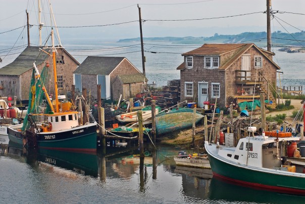
Your trip to Martha’s Vineyard will most likely start in the port village of Vineyard Haven, as it occupies the most protected and accessible deep anchorage on the Vineyard. Vineyard Haven offers an excellent jumping off point for exploring the rest of the island. As the ferry is docking in the harbor, you will find yourself transported amidst a milieu of sailboats. Well known ships, like the Black Dog’s Shenandoah and Alabama tall ships make their anchorages here. Though Vineyard Haven is one of the three major population centers on the island, it is by far the smallest. Main Street is populated with bric-a-brac shops and fine eateries, but the commercial district of the town does not extend far from the harbor. Starting in Vineyard Haven provides a digestible foretaste of what’s to come on your next two city stops on the Vineyard.
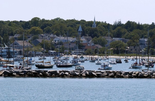
The protected harbor at Vineyard Haven, a safe anchorage for sailboats
It’s time now to hop on your bike and head east along the bridged road that separates Vineyard Haven Harbor from Lagoon Pond. After a few miles of pedaling you will start to see massive Victorian houses appear; you are reaching the outskirts of Oak Bluffs, the Vineyard’s largest town. Oak Bluffs is distinct among Vineyard towns with its unique built environment and its lively culture as well. Formerly known as Cottage City, biking into Oak Bluffs is like riding into a storybook. The ornate ‘Gingerbread Houses’ are cladded with cookie-cutter ornamentation all painted in vibrant pastel shades. These grand old houses line an expansive ocean-side park laden with fountains, flowers, and park benches. Ocean Park, as it is known, is always comfortably busy with families strolling about and children flying kites. It gives off the whimsical aroma of an all-American town.
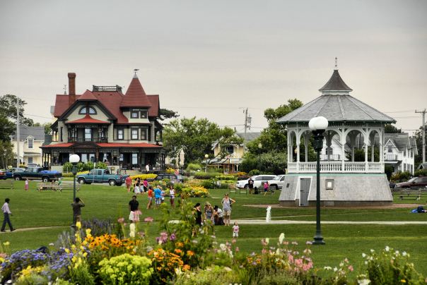
The prototypical All-American Ocean Park in Oak Bluffs
Before the Cottage City was built, groups of Methodists would flock to the Oak grove on the bluff to hold annual summer revival meetings in the early 1800’s. At first their camp colony consisted of a series of tents surrounding a larger meeting tent on the top of the hill. As the years went by, the Methodists gradually upgraded from simple tents to more and more elaborate buildings. Eventually, a large open-air tabernacle replaced the original meeting tent, and a village of Victorian cottages replaced the tents. The Gingerbread cottages then became a tourist attraction in their own right.
Methodists weren’t the only people attracted to Oak Bluffs. The island town has a long history of a community of color. The first blacks in Oak Bluffs were brought to America as slaves. By the 1700’s, freed blacks began moving to the town to seek work in the local fishing industry. The growing African-American population of the town then attracted black business owners to set up shop, adding to the growing community. In the late 19th and early 20th centuries, middle and upper-class African-American families sought out Oak Bluffs as a vacation destination. Unfortunately they didn’t have much other choice in their holiday destinations, as discriminatory laws in all other towns on the Vineyard prevented blacks from renting hotel rooms. Oak Bluffs was the only town that welcomed the presence of black vacationers, and to this day Oak Bluffs remains a destination for prominent families of African-American descent.
Beyond the sheer visual stimuli that is the gingerbread cottages of Oak Bluffs, the main commercial streets are always bustling with tourist traffic. Oak Bluffs was the only town on Martha’s Vineyard consciously planned for tourism, and the businesses on the main drags show it. Walking the streets of Oak Bluffs, one will encounter an unfathomable smattering of ice cream stores, candy shops, souvenir shops, and even a flashy arcade full of jazzy amusements and a carousel. In sharp contrast to the more tactfully hidden tourist nature of the other Vineyard towns, Oak Bluffs pretends to be nothing less than a destination for the masses.
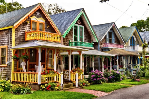
A row of Oak Bluff’s whimsical ‘Gingerbread’ houses
After getting overstimulated in in Oak Bluffs, it is time to stretch the bicycling legs again and take the scenic bike route six miles southeast into the Vineyard’s other most populous town, Edgartown. The trail to Edgartown rides smack between the open ocean and Sengekontacket Pond. This stretch of sand and water is perhaps the most scenic ride on all the Vineyard. Along the path you will cross the American Legion Memorial Bridge, made famous from the movie set of Jaws. Take a quick breather and re-create the shark attack scene. It is also a popular pastime at the bridge to jump into the water. Just when you thought it was safe…

A pending shark attack scene from Jaws, with the famed bridge in the background
Continuing on into Edgartown, you will see more familiar Jaws scenery. The fictional town center of Amity Island was filmed here. The brick sidewalks and wooden buildings provide an olden-day feel to the town. Edgartown has a much more relaxed ambiance than Oak Bluffs. Its maze of streets are lined with shops and eateries which cater to the more refined traveler. Also in Edgartown, you can catch one of the world’s shortest car ferries. At a distance of 527 feet, the ‘Chappy Ferry’ to Chappaquiddick Island is nothing short of endearing. Endearing too is the island itself, lightly trafficked and abounding with beaches, forests, and the Mytoi Japanese Gardens. Continuing south out of Edgartown is another way to escape the bustle of the large towns; some of the Vineyard’s most popular beaches, South Beach and Katama Beach, lie just a short cycle south.
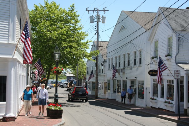
The classic look and feel of downtown Edgartown
After completing the trifecta of the major Martha’s Vineyard towns, it is time to get your bicycling legs in gear and make the long trek to the far western side of the island where the landscape becomes increasingly rural. Out of Edgartown, follow the bike path west. Soon enough, after passing through the outskirts of the town and a few boutique farms as well, you will reach the Manuel F. Correllus State Forest, a sizable patch of pitch pines and other scrubby trees that occupies the heart of the Vineyard. The bike path is far enough off the road and is adequately shaded by the trees so that it starts to feel rather isolated. After a good stretch of smooth riding, the bike path ends. To continue further west, it is time to venture onto the roads. Not to worry, though. Western Martha’s Vineyard takes on quite a different character than the populous tourist towns in the east, and not much vehicle traffic abounds on this side of the otherwise congested island.
To continue west at the end of the paved bike path, take your pick of either North, Middle, or South Roads. As you could probably infer from their names, these roads refer to their geographical location on the island. Once in the west, the hills on the Vineyard begin to get more pronounced. The forest, too, encroaches on the road; the continuous tree canopy is punctuated only by the occasional pastoral meadow. Old stone walls line the road and heirloom cattle graze in the pastures. After riding for a number of miles, you’ll eventually reach the small isolated village of Chilmark, whose claim to fame was a once-thriving deaf community with its own system of signing even before the advent of American Sign Language.

The pastoral landscape along Middle Road on the west side of the Vineyard
The village of Chilmark is a one-horse town, occupying little more than a road intersection with a few boutique shops and community buildings. Take a quick break on your bicycle to look around, but then head north again towards the ocean. A few miles later you’ll reach the quaint fishing village of Menemsha, an aged relic from the days when fishing was still a mainstay of the Vineyard. Take a stroll along the docks and watch the fishing boats offload their catch. Small weathered clapboard shacks line the Menemsha basin and fishermen peddle their wares to off-the-beaten-path tourists. It was this village that served as the home of the salty shark hunter Quint from Jaws. As a special bonus for cyclists only, Menemsha offers the special treat of a bike-only ferry to traverse the stones-throw distance across the entrance of Memensha Pond. After seeing enough fish in the village, take the bike ferry and enjoy the short water transit.
Menemsha, a quite charming active fishing village on the fringe of the island
On the other side of the bike ferry, you’ll find yourself in a land of sand and hills directly lining the ocean. Pause for a moment and think about the eastern end of the Vineyard just fifteen miles back—this has become a vastly different world. Rather than opulent vacation compounds, the houses here are beaten and weathered, laying spattered in the woods like an organic outgrowth of trees. It is here where you will enter into the Wampanoag Aquinnah lands, lands that are still held by the original peoples of the Vineyard. Also, at this point you should notice that you are biking uphill; this means that the spectacular Gay Head Cliffs are quickly approaching.
Once you spot the Gay Head Lighthouse in the distance you will know that you are near the end of the island. At its westernmost point, known as Gay Head, Martha’s Vineyard abruptly drops into the ocean at the Gay Head Cliffs. These cliffs are made up of clay, a dissimilar material to the glacially deposited till that composes the rest of the Vineyard. As a geological phenomenon, layers and layers of the Gay Head clay—former seafloor sediment—were pushed upwards by the weight of the glacial moraine formed during the last ice age. Over time, the ocean has been reclaiming this above-water material and has formed the cliffs via erosion. Wampanoag legend holds that the god Moshup, a benevolent provider, lives in the cliffs. The red stains on the cliffs are from the blood of the whales that Moshup eats, and the black is the soot from the fires that Moshup cooks over. The Wampanoag peoples hold these cliffs and their mud sacred, and as a visitor it is easy to see why. This secluded end of the island is a special place, worthy of admiration. From the overlook of the cliffs, it is an easy enough walk down to Moshup Beach, where one can stroll along the sandy beaches under the towering cliffs. After such a whirlwind tour of the Vineyard, there really is no better ending.
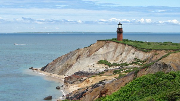
The Gay Head Lighthouse standing tall over the colorful cliffs
Posted on September 14, 2017, in Bicycle, Travel and tagged Bicycle, Bike Touring, Martha's Vineyard. Bookmark the permalink. Leave a comment.

Leave a comment
Comments 0