Category Archives: Geography

Chasing Light

It seems I’ve been chasing light lately. First an Austral Summer below the Antarctic Circle. Then a Boreal summer above the Arctic circle. In a few day’s time, shortly after the autumnal equinox has ushered in fall to the northern hemisphere, I will board a plane and fly back to the southern hemisphere for the start of spring. I seem to have become a season hopper.
With three summers in a row without a winter season in between, you’d be forgiven if you thought I was chasing warmth and sunshine instead of chasing daylight. Though astronomically speaking, the seasons have been summer, traditional ‘summer’ weather has been neither what I was seeking or have experienced. Last December I spent the solstice in Antarctica, though even the peak of summer there felt climactically akin to my brethren at home in the Midwest. This June, I was in northern Alaska for the solstice. Yes, temperatures could rise and be unbearable under the full, circling, blazing sun—but it could also become cloudy and reach temperatures within the range of snowfall. Indeed, though the daylight has indicated summertime, these summer seasons haven’t always seemed particularly ‘summery.’
And here I go again, back to New Zealand, back to the southern hemisphere, and back into another summer season. It wasn’t by design that this happened—circumstances and the development of life decisions just produced this unintended result. While working in Antarctica last October through February, I met someone who convinced me to join her on a thru-hike on New Zealand’s Te Araroa trail. So, while the days are short and the snow falls in the northern hemisphere, I will be on the other side of the globe chasing the warmth and summer season as we hike the island together. As we follow the trail from north to south, we will be reaching higher and higher latitudes where in summer the days become longer and the nights are short.
In the temperate mid-latitudes where New Zealand lies, the distinction between periods of night and day are pronounced, but not extreme. But life, as well as the landscape, reaches towards the extreme the more one goes poleward. And beyond the Arctic and Antarctic circles, the land goes from 24-hour sunlight in the summer to 24-hour darkness in the winter. The polar regions are places of extreme seasonal differences. The summer season knows not the winter season, and the transition between the two is abrupt with only truncated springs and falls. From the sun circling overhead continually in the summer, there is only a short transition until the suns sets and never peaks above the horizon in winter.
I have seen firsthand the way the sun wanders aimlessly around the polar summer sky, circumambulating. At McMurdo Station, Antarctica, 77.5 degrees south, I spent 118 days without a sunset. When it finally did occur, the first sunset of the fall was a momentous occasion. The residents of McMurdo piled outside to watch as their faithful sun companion dipped briefly below the horizon, only to rise less than an hour later. And though the sun had officially set, it was far from night, and would be for quite some time. In the beginning of fall, the sun stays so close to the horizon that it remains civil twilight for hours after sunset. Not until a month and a half after the first sunset of the fall does McMurdo experience its first true minutes of night.

With traditional distinctions between day and night becoming muddled at the poles, day and night become somewhat irrelevant. How is one to tell the passage of time when one cannot tell when one day slips into the next? In summer, the sky remains constantly lit. Day rolled into night, but the night seemed just like the day.
In Antarctica, during the summer season, I ended up working the night shift at McMurdo Station. Though the 24-hour clock that the research station ran on considered the shift to be ‘nighttime’, there was no darkness. The only indicator of night was that the throngs of researchers and science support staff hanging out in the galley would slowly subside; there would be a few hours of peaceful quiet while the station slept, until folks began to roll into the galley for coffee and breakfast at the start of another workday. Meanwhile, in those quiet hours in the wee of the morning, the sun was at its lowest angle on the horizon, sending in radiant beams of light through the bank of galley windows—a middle of the night golden hour.
I had no problem adjusting to working the night shift after spending my first few weeks on station as a daytime worker—the sun was as bright as always, and I did not feel like I was sleeping away and wasting daylight as I had felt when I worked overnights for big-box retail. Inside my windowless McMurdo dorm room, the lights were always off. When I needed nighttime, I could retreat to my room and sleep soundly out of the sun. But were I to choose to go out and play instead, the sunlight would be my constant companion.
I had more experience living under the midnight sun this summer, as I led a 50-day backpacking trip north of the Arctic Circle to Alaska’s Arctic National Wildlife Refuge. Our latitude was not quite as high as McMurdo—only at 69 degrees latitude—thus the extremes of sunlight were not as pronounced. But what this trip to Alaska lacked in sheer latitude, it made up for in intensity of experience. Gone were the modern conveniences of McMurdo Station. There was no longer any indoors to hide in, no eternally dark dorm room or dimly-lit dark bar to retreat to. Instead, we were out in the backcountry with no more than we could carry upon our backs. Our only shelter was a thin-walled tent, and the daylight filtered right in. We either made friends with our eyemasks, or we learned to sleep in the light. Once again, the time of day became irrelevant—there was no hiding from the constant presence of the sun.
It took a number of days before I lost the nagging feeling that comes after looking at the late hour on my watch and feeling the pressure to get a hustle on to make camp before darkness falls. Throughout the duration of the trip, I kept tabs of the time on my watch—not out of necessity, but more out of a curiosity of how our circadian rhythms were adapting. Our days slowly dragged out to be longer, as we stayed up later enjoying each other’s company and slept in longer the following mornings. Thus, we ended up being awake through the darkest hours of the day, and even towards the end of the trip after the sun had been setting below the horizon, the light remained with us. Even in the depth of night on our last day in the Wildlife Refuge, it remained light enough in the tent to read a book.
In spite of the mounting fatigue from daylight that comes with constant exposure to lightness, I appreciated the daylight as a benign and amiable companion in a remote and unfamiliar terrain. Here we were, traveling for weeks in the Arctic National Wildlife Refuge, where wolves and grizzly bears roam wild. The signs of these animals were all over—tracks, scat, kill-sites. But the daylight made the wilderness seem friendlier. All told, we saw six wolves and seven grizzly bears on the trip. Seeing the bears and watching their natural disinterested movements in the daylight provided much more psychological comfort for us than wondering if out in the darkness somewhere was a bear lurking just outside the tent.
At about the same time on the trip that I began to miss the creature comforts of home—dry feet and doorways instead of tent zippers—I also began to miss the darkness. Aside from being able to sleep better in the darkness, I began to miss darkness not for darkness itself, but for what it brings to us. The constant daylight drowns out the stars all polar summer long. I’m constantly reminded that people forget this, as I am asked quite often if I saw great stars or aurora. Unfortunately, I was able to see neither stars nor aurora, much to the disappointment of my star-gazing self. And too, having the darkness creep in at the end of the day provides a natural daily cycle of gathering in your shelter for rest. Darkness too, lends itself to gathering around a campfire for light and warmth. Though we did have a campfire on the riverbank one night in Alaska, the magic of the fire just wasn’t the same in the light hours.
As much as I began to miss the darkness, when it finally did come, it felt uncomfortable and foreign. Towards the end of our trip, the nights had been gradually growing dimmer. But right after leaving the Wildlife Refuge, we caught a shuttle ride to Fairbanks, which sits below the Arctic Circle. Darkness descended upon us as we camped in Fairbanks that night. For the first time in nearly two months, it was no longer light enough outside to walk around without a headlamp. The feeling was unfamiliar. Suddenly all the scary feelings of darkness came rushing back in that gut-wrenching primordial fear of the unknown. My how easy it is to forget what darkness is like!
This coming summer, the distinction between day and night will not be as pronounced as I hike the Te Araroa as it was when I spent time closer to the poles. The mid-latitudes will provide a kinder balance of light and darkness each day. Nevertheless, as fall and winter begin to descend on the northern hemisphere, I will once again be off chasing light.

State of Mind, State of Being
space
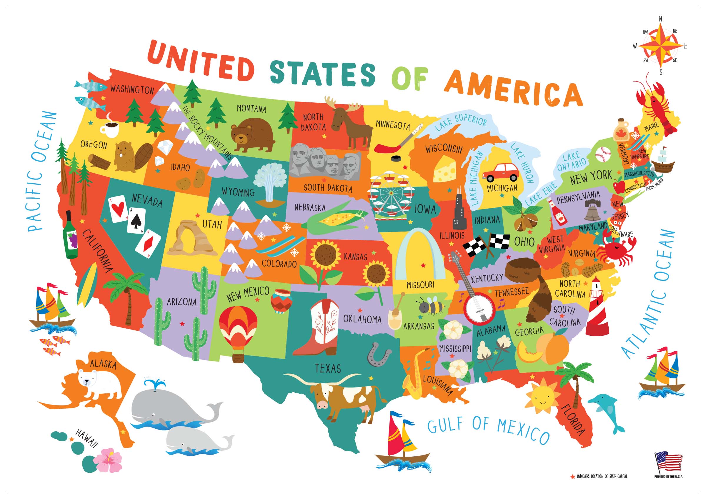
The United States of America, with its fifty nifty geographical sub-units, neatly divides up this diverse nation into different states that each has a generalized culture and personality. As someone who is not yet settled down with a permanent address, I still have the flexibility and open-endedness to decide which state I want to live in for the long haul. From working jobs in a variety of locations, I have gotten a taste of many different geographies, a smörgåsbord of potential places to call home. In any given year, I seem to work in about three different states, which doesn’t usually include my birth state of Michigan. This prolonged period of ‘geographical investigation’ has given me some insights into where I might want to settle permanently based on my experiences in each state. While I have explored around the country quite a bit (see this page on my personal website for the most up-to-date map of U.S. counties I’ve been to), I’m a northerner at heart—I’ve never stayed long in a place under 40°N. And while I’ve worked jobs on both the East and West Coasts, I always return home to the Midwest.
From my adventures, I have my own thoughts about potential locations to settle, as well as to what my ‘soul state’ might be. But I thought I’d elicit some help from the omniscient ether—by taking a number of sleazy internet quizzes to see where the quiz writers think I belong. These quizzes—though far from scientific—are quite fun to play around with. I’ve listed them here according to my self-rated quality of the quiz, from best to worst:
What were my results? Out of seven quizzes taken, surprisingly none of them yielded the same state. However, there seems to be a strong connection to northern New England, as I was matched with Maine, New Hampshire, and Vermont (even though New York is not considered part of New England proper, I’ll clump it in with this category because the most desirable part of New York for me, Upstate, has a lot in common with northern New England). These four states—charming small towns, more rural populations, historic places, and winding roads through hills and deciduous forests—all seem to be a good match for what I’d be looking for in a habitat. The quiz from Quizony was the only one that picked what I consider to be my ‘soul state’ of Vermont: fiercely-independent, sustainability-minded, ample greenery, and the fewest Wal-Marts of any state.
space

space

space

space

space
And as for my natal Midwest? Sadly, no quiz matched me with my birth state of Michigan. I guess it turns out that I don’t fit in with the bulk of the state, though I think quite highly of life in the rugged frozen Upper Peninsula (Yoopers are a special breed, and I don’t think I could ever live up to their cred). I was quite happy that Wisconsin appeared as a match. I really am fond of the upper Great Lakes region, especially around Lake Superior, and I’ve been quite frequently perusing for real estate in northern Wisconsin. Cheese curds and a good football team? Count me in.
space

space
Then there were two far-flung results. Washington State, with its forests, mountains, and avid outdoor recreation culture seems to be a good fit for me. And though I enjoy visiting and recreating in the west, the West Coast has never really felt like home to me. Finally, my most out-there match was with Tennessee, provided by Buzzfeed. Apparently the quiz determined that I have an undiscovered penchant for country music that makes me belong in the South (even though when given the quiz question for musical preference, I explicitly chose rock over country).
space

space

space
Of course, no online quiz can ever compare with the process of getting to know a state in person. So get out there and start exploring to find your own perfect state!
space
space
space

The Socially Distanced Cyclist: 16 Days, 1,170 Miles, and Minimal Human Contact Around the Coast of Lower Peninsula Michigan
From August 9 to 24, 2020, I took a solo, self-supported bicycle trip to explore the coastline of my home state, the great state of Michigan. Being the Great Lakes State and a water wonderland, Michigan offers 3,224 miles of freshwater coastline to explore as well as 124 lighthouses, both of which are the most of any state. The following is a summary the trip, encompassing 16 days, 1,170 miles, and following the coastline of Lake Michigan and Lake Huron around Michigan’s Lower Peninsula.
Approximate Route:

Day 1: Familiar Territory
Zeeland to Muskegon State Park: 67 Miles


It was a beautiful summer Sunday afternoon when I finally departed for my trip after a much longer than anticipated morning of final preparations. Bluebird skies and temps in the 80’s made it a day more fitting for a beach holiday than a long, sweaty bike ride. I would start the trip covering very familiar territory, a survey of the Lake Michigan beaches within just a short driving distance of where I grew up. I hopped on my overloaded bicycle and listened to the new squeaks and groans as the immense weight found its equilibrium on my old Cannondale, crossing my fingers that no spokes would snap (wanting to keep myself socially-distanced as possible, I chose to pack around 35 pounds of food so I wouldn’t need to re-provision the entire trip). My first leg would be the twelve mile distance to the white sand beaches of Holland State Park, with a ceremonial stop to see my beloved ‘Big Red’ Lighthouse, which would mark the first of many lighthouses I would stop to see on the trip.
The Holland area boasts many wonderful non-motorized recreational paths, and I followed one of them along Lakeshore Drive, past many lakeshore mansions, nearly all the way to Grand Haven. Grand Haven State Park, another beautiful white sandy beach, was packed with beach revelers on such a gorgeous day. From Grand Haven, I crossed the drawbridge over the Grand River and proceeded northward to Muskegon. This first day of the trip was marked by getting through some of the bigger metropolitan areas on the lakeshore to the less developed lands of the northern counties. North of Muskegon lies Muskegon State Park, a much quieter and forested lakeshore dune park than both of the state parks I had visited earlier. It was at Muskegon State Park where I would first camp for the night, and, as an omen for a good trip to come, I found a $20 bill on the road leading to the park.
Day 2: Storm’s A-Brewing
Muskegon State Park to Ludington: 72 Miles


Day two started fairly leisurely on the sandy beaches of Muskegon State Park, followed by a stimulating up-and down ride through the tree-covered dunes to the Blockhouse, the highest point in the park which offers great views of the dune ecosystem. Continuing northward, I followed the aptly-named Scenic Drive paralleling the lakeshore until I reached White Lake and the twin villages of Whitehall and Montague. As recommended, I found the Hart-Montague Trail, which was Michigan’s first Linear State Park and one of the earliest instances of Rail-to-Trail conversions in Michigan (1991). The Hart-Montague Trail runs for 22 miles and connects several small country towns that offer ice creameries and small cafes. Being a former railway, the trail is undeniably flat and straight, with mostly shrubs and brush for scenery. A few miles shy of Hart, I got the itch to return to the lakeshore for more expansive scenery and some hills for interest. I turned west towards the lake and the sand-buggy enclave of Silver Lake. Though I yearned to make the short detour to the remarkable Little Sable Point Lighthouse in Silver Lake, dark ominous clouds had begun building to the west.
I followed roads along the lakeshore through the city of Pentwater and past the cottages of Bass Lake. A few miles south of Ludington, the road passes right by the Ludington Pumped Storage Plant, once the largest pumped storage plant in the world! During the night, when there is excess electricity generated, the plant will pump water from Lake Michigan up into a 1.3 square mile reservoir over 350 feet above the lake. Releasing this water during the day generates supplemental electricity during peak demand. I stopped to gawk at its massive industrial workings, until a security guard came and asked me to leave. The guard said they were shutting down the overlook due to impending weather and showed me the radar on her phone. Yikes! I made a mad bike dash down from the high dunes to the city of Ludington, where I fortunately was able to set up camp before the heaviest rains set it. It was an eventful night as lightning flashed and thunder cracked overhead, but this would prove to be the only rain encountered on the whole trip.
Day 3: This is Hilly Amazing!
Ludington to Sleeping Bear Dunes National Lakeshore: 78 Miles


The storms had passed during the night leaving me with wet gear, but a warm sunny day proved to be in order once again. North of Ludington, Hamlin Lake and Nordhouse Dunes (Lower Michigan’s only federally-designated wilderness area) block road access to the lakeshore, so I took an inland route of country roads through the matrix of forest and small farms. Riding into Manistee took me back to the lakeshore, and proved to be stop with plenty of great parks to relax at along the lakefront. A few miles north of Manistee, while riding on Lakeshore Road, I got caught up in paying too much attention to a car behind me as I looked to turn left towards the beach access. My front wheel slipped off the paved roadway immediately bogging down in the soft beach sand and causing a slow-motion flip over the handlebars. Aside from a few superficial scratches on my hands, knees, and bike, I was shaken, but OK.
I continued on, albeit more wary of soft shoulders now, around Portage Lake and the small town of Onekama. Onekama is the southern terminus of Michigan Highway 22 (or M-22), that famed route whose highway sign is emblazoned on merchandise and bumper stickers all over Michigan. Reaching M-22 proved a dramatic change in riding conditions; here, the hills began. Whereas up until now things had been remarkably flat, M-22 began a series of long, winding, gradual 1-to-2 mile climbs up a sand dune, followed by a speedy descent on the other side. I maxed my downhill speed out at 39 MPH, which on a fully-loaded bicycle is simultaneously exhilarating and terrifying. I broke up the hill climbs with stops at the little Victorian town of Arcadia’s city beach, and at the much more bustling tourist town of Frankfort. I then turned my route inland toward the town of Beulah, in search of cherry pie and wine. Riding from Frankfort along the sizable Crystal Lake proved no relief from the hills, and slower travel over the terrain caused me to miss out on the treats found in Beulah. Hungry and exhausted, I made my camp for the night just a few miles to the north in the Sleeping Bear Dunes National Lakeshore.
Day 4: I Bearly Got Anywhere Today
Sleeping Bear Dunes National Lakeshore: 37 Miles


However exhausted I was from the hill climbs the day before, I woke up very excited for the route I would cover today. I would be traveling through the Sleeping Bear Dunes National Lakeshore, perhaps the most scenic stretch of land in the Lower Peninsula (indeed, Sleeping Bear was named ‘The Most Beautiful Place in America’ by ABC’s Good Morning America in 2011). My bike, however, seemed less up for the challenge. As I had feared, all the popping and groaning coming from my crank were signs that my bearings were going bad, and my crank assembly had been growing disconcertingly looser and looser since day two. I would need to make a pit-stop to have that taken care of before I found myself stranded with no pedals to pedal.
I followed the quiet stretch of M-22 into the tourist outpost of Empire, where I met up with the Sleeping Bear Dunes Heritage Trail. This trail winds through the woods through most of the park, providing most excellent riding scenery. The trail also goes over some very steep dune sections and around some very sharp curves which makes for a sendy route to keep riders on their toes. Highly recommended is the Pierce-Stocking Scenic Drive, which winds a course of seven miles over some of the biggest dunes in the park and past some of the best vistas of Lake Michigan on top of the 400-foot tall sand dunes. Unfortunately for me, and maybe fortunately for my bike, the Pierce-Stocking drive was closed in 2020 due to road construction. However, a short distance north is the epic ‘Dune Climb’, a large active dune blowout that guests are encouraged to climb. The vantages from the top are quite spectacular, and offer sweeping vistas of Lake Michigan, the dune systems, and the valleys inland. Sleeping Bear Dunes also offers opportunities for history hounds as well. Just north of the dune climb is Glen Haven, a former fishing company town that the National Park Service now maintains as a historic village. Tucked in pockets around the park are also the barns and farmhouses of homesteaders of yore. In the course of time, most homesteads folded in the region, and the main economic driver switched to tourism.
I finally stopped to have my bike repaired in Glen Arbor, and the mandatory afternoon of downtime was well spent enjoying a swim in the crystal blue waters of Lake Michigan, as well as doing some tourist shopping in Glen Arbor itself. Not a big day distance-wise, but one of the best places just to enjoy some time in the splendid destination.
Day 5: Up and Down on Leelenau
Leland to Traverse City: 84 Miles


Back in 2012, I had taken a short bike vacation with my parents to the Leelenau Peninsula, and this area offers so much for the bicycle tourist on shorter trips as well as longer ones. The bigger towns of Leland, Northport, and Suttons Bay all offer their own vibe and tourist amenities. I started my day by following M-22 into Leland, of which any stop requires a mandatory visit to the historic and artsy Fishtown. A pleasant and lightly-trafficked ride north on M-22 took me to the quiet town of Northport. About an 8 mile ride north of Northport, past many cherry orchards, I reached the very tip of the Leelenau Peninsula which is home to a state park and the impressive Grand Traverse Lighthouse. The lighthouse was open to tours, though the tower was closed due to COVID.
On my way south on M-22 towards Suttons Bay, just past Omena, I crossed over the 45th Parallel (I had actually crossed over it earlier in the day between Leland and Northport), which, being the geography nerd that I am, necessitated a reason to celebrate. The closer I got to Suttons Bay, the more traffic M-22 picked up, and the worse shape the road became. Though riding M-22 next to Grand Traverse Bay was scenic, I was happy to beat the traffic by picking up the TART Trail (Traverse Area Recreation and Transportation Trail) going into Traverse City. Being the ‘Cherry Capital of the World,’ I biked past many cherry and fruit orchards on my way into the city.
Day 6: On a Mission
Old Mission Peninsula to Charlevoix: 78 Miles


The start of the day would take me onto the Old Mission Peninsula, the very long and narrow stretch of land that neatly divides Grand Traverse Bay in two. I peddled up the Peninsula on the west side’s Peninsula Drive, which offers a very quick and flat route to the tip, going past miles of miles of really fancy waterfront properties along the way. At the tip of the Old Mission Peninsula lies the Mission Point Lighthouse and a nice beach with crystal clear waters. The route back to Traverse City, along the main highway M-37, offered quite a contrast to the solitude and ease of Peninsula Drive. M-37 goes through the middle of the Peninsula, meaning the road goes up and down many hills as it winds its way mostly through vineyards. Though the hills were challenging, they did provide some incredible vistas of vineyards and Grand Traverse Bay. Had it not been before 10AM, I would have stopped for a tasting.
Once back into Traverse City, I caught the TART Trail to its eastern terminus in Acme, a few miles away. I was glad to avoid the heavy development and tourist traffic along that stretch of US-31. Once the path ended, I followed the signed bike route through some bucolic country acres until I ended up at US-31 again. During route planning, I had wanted to bike that stretch of US-31 as it passes on a narrow strip of land between Lake Michigan and both Elk Lake and Torch Lakes. In hindsight, this was the only section of my route that I wish I had changed. US-31 along that stretch has only a narrow, crumbling shoulder, and the summer tourist car traffic is constant. Even worse, the route has absolutely no views of any lake along the way. As a plus side, though, the heavy tourist traffic does bring with it an abundance of roadside food, fruit, and sweet stands, and Elk Rapids makes a nice town to stop at. Given that it was an exasperatingly hot and sunny day, I made my fill of stops along the way to replenish my belly and refill my electrolytes with some pasties, pastries, and apple cider.
Day 7: Through the Tunnel of Trees
Charlevoix to Cross Village: 81 Miles


Whereas the previous two days were spent biking around the Grand Traverse Bay, today I would bike around the Little Traverse Bay. First stop of the day was in the harbor town of Charlevoix, outside of which I picked up the Little Traverse Wheelway bike path. With the underlying bedrock of the region being limestone here, I made several lengthy stops along the lakeshore to try my hand at fossil hunting. Being so close to Petoskey, I was really hoping to find a stellar specimen of the city’s namesake and Michigan’s state rock (even though Petoskey stones are indeed a fossil, they are not Michigan’s state fossil). Alas, good specimens of Hexagonaria coral (AKA Petoskey stones) were difficult to find, but it doesn’t take an expert paleontologist to soon pick out many other fossils in the mix; fossilized horn corals, bivalves, brachiopods, and crinoids all make the lakeshore a Devonian paleontologist’s playground. Following the nicely-paved Wheelway around Little Traverse Bay will take you to the towns of Petoskey and Harbor Springs, both of which offer plenty of dining and shopping amenities. Petoskey offers a large historic downtown area built into a hillside, whereas Harbor Springs caters to the yacht club upper-crust.
Past Harbor Springs, following Michigan Highway 119 (M-119) is both the motorist and cyclist eye-candy route known as the ‘Tunnel of Trees’. The Tunnel of Trees is a splendid, curvy, 1 1/2 lane highway that encourages you to slow down and enjoy being immersed in the trees as the highway meanders along a sand dune bluff for nearly 20 miles. Traveling, as I was, on a mostly cloudy evening, I encountered very little auto traffic (I let my eyes wander once again, forgetting entirely my days-earlier episode of crashing my bike). At the northern end of the Tunnel of Trees is the tiny settlement of Cross Village, most notably known for its iconic roadhouse, the Legs Inn. In the 1930’s Polish immigrant Stanley Smolak, along with the help of local Odawa craftsmen, began to build the fantastical building using local stone and driftwood. It is highly recommended as a place to eat, or at least walk in and feast your eyes on the décor. Wait times often exceed one hour. Though a hot meal and a beer sounded nice after such a long day, I was burning daylight and had to get to my campsite near Wilderness State Park.
Day 8: In the Straits, not in dire straits
Wilderness State Park to Mackinac Island: 45 Miles


Wilderness State Park is a fantastic, remote expanse of land on the northwest tip of lower Michigan. It offers wide swathes of pine forest and vast expanses of sand dunes, and is highly recommended to spend a full day there. My time in Wilderness State Park would prove eventful. I had just started biking for the day when I came around a corner and saw two young men frantically waving for me. I caught glimpse of a motorcycle stuck under a truck, which is what they were making a big fuss about. I stopped to help the two guys, both named Tyler, incidentally, to get the motorcycle out from under the truck. By that time, I had already pieced together the narrative that the man with the fresh patches of road rash had lost control of his motorcycle going around the curve, and had slid under the parked truck. Fortunately everyone was OK, and I helped Tyler clean up his road rash a bit. Of the three of us there, only my flip phone had cell service, and I stayed with them until they arranged a tow. Flip phone for the win!
Since I no longer had time to explore the vastness of Wilderness State Park, I picked my way along rough rural roads in Emmet County towards the very tip of the Mitt at Mackinaw City. Along the way, however, I couldn’t resist stopping when I saw a sign for the McGulpin Point Lighthouse (which, by the way, you could actually climb the tower). From the McGulpin Point light tower, I could get a great view of the Mackinac Bridge spanning the Straits of Mackinaw. I was at the tip of the peninsula, but the Mackinac was a bridge I would not cross (at least not on this trip). Nearby the lighthouse is the Headlands International Dark Sky Park, and the region is perfect for stargazing on a clear night.
Now that I was halfway through my ride and at the tip of the Peninsula, my crowning stop would be an afternoon spent on Mackinac Island, Michigan’s iconic and premier island destination. A former British fort and a tourist destination since the mid-1800’s, Mackinac Island was once even briefly a federal National Park (1875-1895). Today, the island is known for its bikes and horse-drawn carriages, its Victorian architecture, its fudge and tourist shops, and for being carless. It is a half-hour ferry ride to the island from Mackinaw City, and to get to the ferry terminal you have to pass through all the shops of downtown Mackinaw City that are hawking fudge and T-shirts. Once you land on Mackinac Island itself, you’ll be in downtown and will walk past all the shops hawking the same fudge and T-shirts as the mainland. But when you’re on the island, it’s special, and I did the touristy thing of buying fudge, popcorn, and postcards. The island is also great for history buffs, given Fort Michilimackinac and other historic buildings to tour, but I was there for the bike riding. A right of passage on the island is to bike the 8 mile loop on M-185 that rings the island. I had biked around the island once before on a family trip when I was in fifth grade, but biking on my own as an adult was so much better. Of course I had to make a stop at some of the iconic geological formations such as Arch Rock and Skull Cave. And there was no better way to cap off the day than by getting ice cream from the shop below the Grand Hotel’s world-record 660′ long front porch.
Day 9: Lonesome Limestone Highway
Mackinaw City to Thompson’s Harbor State Park: 74 Miles


United States Highway 23 offers a dramatic contrast to the commercialism of Mackinaw City. Never before had I been to northeast Lower Michigan. It is an region of small towns separated by large distances all built on the extractive industries. From Mackinaw City to Cheboygan, the North Central State Trail follows an old railroad grade paralleling Highway 23. Though the crushed gravel of the state trail was nice, I found I preferred the feel of pavement and the glimpses of Lake Huron that riding on the road afforded me. Traffic was light and the shoulders were wide, which meant great riding conditions.
The surrounding waters of Lake Huron are extremely treacherous, and have claimed hundreds of ships and lives over the centuries. These shipwrecks are all protected within the Thunder Bay National Marine Sanctuary. Forty miles from the Straits of Mackinac is the Forty Mile Point Lighthouse. Several shipwrecks lie in shallow water just offshore, but the remains of the 1905 wreck of the J.S. Fay lie on the beach near the lighthouse. Snorkeling, SCUBA diving, kayaking, or glass bottomed boat tours are all the best ways to see the wrecks.
From Forty Mile Point, one can get on the paved Huron-Sunrise Trail, which leads to Rogers City. Though Rogers City is small, its status as the only town of 1,000 or more people for 30 miles in either direction means that it has all the amenities a person would need. Rogers City is built on mining—mining the fossil-rich limestone bedrock that dominates the region. The limestone is crushed and used as an ingredient in cement, and Lake Huron provides easy access for shipping to distant markets. Outside the city is a special overlook that peers into the massive strip mine that gives Roger’s City its lifeblood. The Calcite Quarry, at over 1,800 acres, ships out 7 to 10 million tons of limestone each year.
Leaving Rogers City early in the evening, the sun was beginning to shine lower and lower on the horizon, while the blue open skies made the late sunshine feel quite tangible. I took a detour off of US-23 at Thompson’s Harbor State Park to search for the Presque Isle Lighthouses. Without directions or a detailed map, I followed an unnamed dirt road hoping it would take me to the lighthouses. The road dead ended at the outlet where water from Grand Lake flows into Lake Huron. The low gleaming sun, the slight warmth in the gentle breeze, the sound of the rocks rolling in the surf—it aligned all too perfectly. I had to stop right there for the day—I had to sit down and just bask in the beauty of the experience. If anything, that evening spent on the beach of Thompson’s Harbor was the defining spiritual experience of the trip. The video encapsulating my experience is included above.
Day 10: Here On Huron
Thompson’s Harbor State Park to Oscoda: 76 Miles
")


After my euphoric evening at Thompson’s Harbor State Park, I had to follow up with nothing short of a pre-breakfast swim in Lake Huron. My morning route would continue around Grand Lake to the small sleepy enclave of Presque Isle. I would find both the old and the new Presque Isle Lighthouses on a peninsula, and, not unexpectedly, both were closed for the summer. Nevertheless, taking the detour around Grand Lake to those small communities and idyllic harbors was well worth it. After passing another large limestone quarry, I reconnected to US-23 and had a short ride into the city of Alpena.
Alpena hails itself as the ‘Sanctuary of the Great Lakes’ owing to its location at the center of the Thunder Bay National Marine Sanctuary. It is a large city, as far as cities in northeastern Michigan go, and along with the extractive industries of fishing, lumbering, and limestone quarrying, Alpena boats a modest maritime tourist economy as well. Unfortunately the highly acclaimed NOAA Museum and adjoining glass-bottom boat tours were closed due to COVID. At this point in the trip, I had grown terribly tired of the food I had packed from home, so I stopped in downtown Alpena to get the greasiest cheeseburger Alpena could offer. While seated at the restaurant, a middle-aged couple started up a conversation by saying that they had seen me yesterday riding from Mackinaw City. We chatted a while about our Michigan travels, and they seemed thoroughly impressed by my stamina. They also paid for my meal.
I left Alpena headed south on US-23 on the mostly empty road past the endless forest. A peculiar place to stop would be Ossineke, where giant sculptures of Paul Bunyan and Babe the Blue Ox great travelers on the highway. Nearby, a gigantic Jesus holding the earth aloft in one hand beckons visitors to come visit the Dinosaur Gardens Prehistoric Zoo, an eclectic and anachronistic mix of cavemen, dinosaurs, and Christianity. By the time I was ready for a break, I was passing by the small town of Harrisville, and I saw a sign for an outdoor concert at the lakefront pavilion. It was some good foot-tapping folk music being played, and after a few songs an announcement was made that it was the organizer of the concert series birthday today. A homemade carrot cake was cut up to celebrate. I was invited by a women to grab a slice. What great small-town hospitality! South of Harrisville, US-23 travels right next to Lake Huron, on what is called the ‘Sunrise Coast’. In a long stretch from Harrisville to Oscoda, the lake is lined with second homes and vacation rentals. I think I finally found where most of the east-siders go on their summer vacations.
Day 11: To the Thumb Pit
Oscoda to Standish: 71 Miles


The twin villages of Au Sable and Oscoda mark the finish line of one of Michigan’s most epic races: The Au Sable Canoe Marathon. In the race, competitors start 120 miles upstream in Grayling, paddling through the night to reach the finish line near Lake Huron. The race was cancelled in 2020, but seeing so many fine rivers as I biked along the coast made me itch to get out and paddle again.
A short distance later, I would be coming upon the start of the ‘Thumb Pit,’ better known as Saginaw Bay. The Tawas Point Lighthouse marks the start of the bay on the northern end, and Tawas City is a small tourist enclave. Continuing south on US-23, the highway is flat and runs right along the lakeshore. The tourist resorts and second homes disappear, and the landscape consists of forest and utilitarian buildings. Maybe it was something about this road, or maybe it was because I just started to put my head down and ride, but I began to notice an abundance of quarters, nickels, and dimes scattered on the shoulder. Another roadside find was a ‘Don’t Tread On Me’ flag, which was evocative of the region’s independent and libertarian leanings.
Day 12: Thumbs Up
Standish to Port Austin: 77 Miles


Today I would round Saginaw Bay and enter Michigan’s Thumb. Pure geographical curiosity had me wondering what it would be like to visit, though I have heard that the Thumb is very flat, rural, and agricultural. The rumors proved true: the Thumb is incredibly flat, rural, and agricultural. Very small farm towns dot the landscape. Biking south on M-13 going into Bay City, I passed through Pinconning, Michigan’s Cheese Capital. On the Thumb, the town of Sebewaing has a large sugar beet processing plant. It was not until the very tip of the thumb, in the towns of Caseville and Port Austin, where vacation homes and tourist attractions began to sprout up along M-25 by the lakeshore. The thumb-tip also offers a couple of nice state parks with sandy swimming beaches.
Day 13: Last Day Along the Lake
Port Austin to Lakeport: 84 Miles


Starting from the tip of the Thumb, today would be my last day biking along the lakeshore as I made my way south on M-25 towards Port Huron. M-25 runs right along Lake Huron, passing many small towns along the way. Even though the route is right next to a Great Lake, it remains agricultural and undeveloped. I biked past the historical company town of Huron City and then past the Point Aux Barques Lighthouse and former U.S. Life Saving Service Station. I continued biking past many sleepy towns enjoyed by the R.V. crowd, until I passed through more touristy enclaves like Lexington and Lakeport as I neared Port Huron.
Day 14: Eastward
Lakeport to Flint: 96 Miles

Alas, all good things must come to an end, and I was about to wrap up my travels along the Great Lakes and start the long trek eastward back to my starting point in Zeeland. I couldn’t help but say goodbye to Lake Huron with one final swim at Lakeport State Park. From Lakeport I would pedal eastward through the farm country in the heart of the state. I passed through small towns named Yale, Lynn, Capac, and Dryden. The roads were rough and had limited shoulder, and I bet that road bikers are a rare occurrence there. However, even with the unseemingly busy roads and all the trucks trying to get past me, every driver was courteous. By the time I biked to Metamora and Hadley, the farmland had turned to hills and forest. I would end the evening on the outskirts of Flint, after a very long, hot and sunny day.
Days 15 & 16: Wrapping Up
Flint to Middleville to Zeeland: 115 & 35 Miles

One final, scorching hot day was ahead of me as I aimed to make it to my friends Robert and Becky’s house in Middleville for the evening. From the outskirts of Flint, I was immediately back into farm country. I would pass through Durand, home of the Michigan Railroad Historical Museum. I would also pass through Laingsburg, where I began running into fleets of spandexed cyclists out for a Sunday morning ride. Out of Laingsburg, I would follow country roads that ran along the crisp and cool Looking Glass River, being thankful for the trees lining the road that provided some measure of relief from the sun. Once past the outskirts of Lansing, it was all sun-beaten farmland until Middleville. Wanting to avoid traffic, I wandered down country roads, meandering generally East and South towards my destination. While I succeeded in avoiding traffic, I also never ran into the gas station that I had optimistically been counting on to replenish my desperately low electrolytes. By the time I arrived at Robert and Becky’s house, it was well past sunset. An incredibly long day, but one the prospect of seeing old friends again had motivated me on towards.
From Middleville, it was a chip shot of a day to finish the remainder of the trip back to Zeeland. More meandering and country roads, and the unanticipated stretch of country gravel, but 35 miles later I had made the trip complete.

A Royal Walk: Hiking across Isle Royale
The Sun Rises Over Isle Royale
It was the middle of May 2018 when I first landed on Isle Royale. That storied island—that mass of rock isolated in northern Lake Superior. So far away it seems logically like it should be part of Canada, yet it belonged to Michigan—the only National Park in my home state. The mystery of that island beckoned me from maps with its geography and isolation. Long had I wanted to discover what this coveted gem had in store.
At long last, I finally visited the island after spending a winter and a spring teaching environmental education in northern Minnesota. By that time, I had become quite familiar with the boreal northwoods from all those hours teaching kids in the wilds. The northern forests, hence, were not all that different from my everyday existence.
Given my years of anticipation, Isle Royale was bound to be something exceptionally different than what one could experience on the mainland, I believed.
As it was, my first trip to the island was a simple, short overnight stay, ferrying in from Grand Portage, Minnesota to the Windigo Visitors Center on the western end of the island. As far as landscapes go, the flat, forested, mixed-conifer forests of Windigo are not spectacularly different than the Minnesota Northwoods I had become accustomed to.
I was a bit underwhelmed.
I didn’t even bother to take any pictures (incidentally, my camera had broken earlier that trip).

Arriving at Washington Harbor at Windigo
I left Isle Royale that trip convinced that I had seen the island in the wrong way. A simple overnight trip was no way to do the island ecosystem justice. If I was ever to return to Isle Royale, I thought, I would do it in the right way: I would hike the island from end to end, slow enough to absorb the ecological transitions, to understand the essence of what makes the place, and to enjoy immersion in the vast isolation of Isle Royale.
As chance would have it, in the summer of 2019 I was selected to take part in a volunteer restoration crew on Isle Royale’s Rock of Ages Lighthouse. I would be returning to Isle Royale sooner than I had thought, and this time, I would be staying on to hike across the island afterwards.
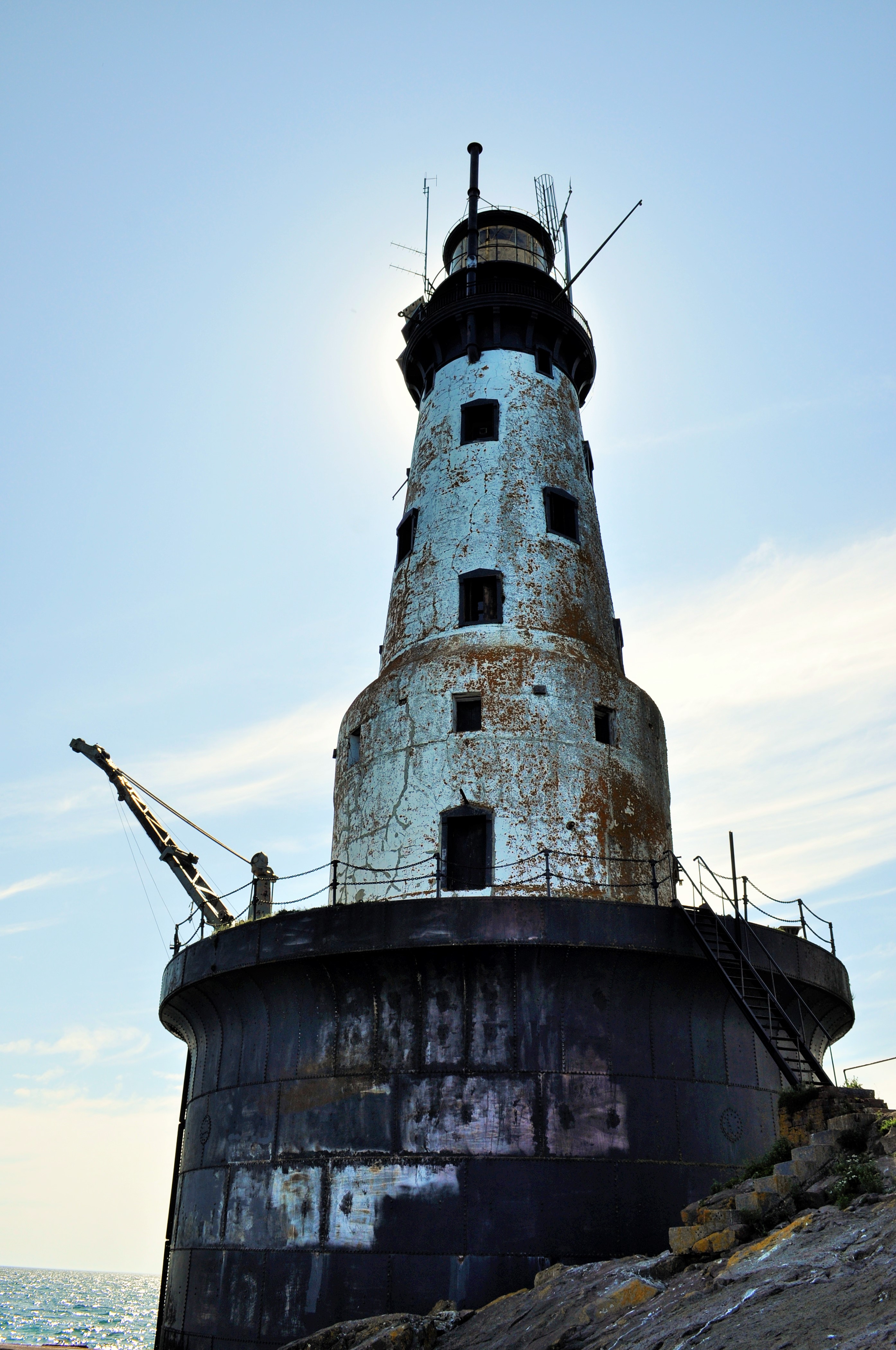
The Rock of Ages Lighthouse
I started my hike on the western end of the Island, at Windigo, the widest part of the island. Here the forest commands the land and the coastline is smoother, less jagged. I made my way to the Greenstone Ridge trail, the hiking path that transects the middle of the island. Despite its name, the Greenstone Ridge at this point isn’t much of a ridge at all. The trail slowly climbs uphill under the cover of a mixed-forest—conifers, but also maples and even the warm-and-dry loving oaks. I spent my first night at the interior campsite of Island Mine, the site of an 1870’s copper mine that peaked and was abandoned in only a few years.

Broadleaf forests found more commonly on the western end of the island
Mining history would be a big theme of the hike, and copper was the resource of value. It wasn’t just white Euro-Americans who were mining the island either: the Ojibwe, the indigenous people of Isle Royale, had mined the island for thousands of years. Archeological evidence suggests that as early as 4500 years ago, indigenous people harvested copper by using stones to hammer off chunks of native copper from outcroppings in the bedrock. As their technology progressed, they began to mine deeper in the bedrock by building large fires over ore deposits, then quickly dousing the fire with water in order to crack the bedrock. Small indigenous mining pits can still be seen throughout Isle Royale today. By the 1840’s the Objibwe had been duped into ceding their lands to settlement and development for the resource-hungry Americans. Speculators flocked to the island to make their riches, but mining on Isle Royale was always boom or bust. Island Mine organized in 1874 and extracted over 200,000 pounds of refined copper. Three years later, the company went bust. All that remains now are scattered pieces of rusting equipment and mounds of tailings.


Day two saw me continue east along the Greenstone Ridge. After a few miles of hiking through the shady canopy, I began to get my first views from the ridge: small, rocky clearings at first with scrubby oaks and small shrubs partly obscuring the views. First the clearings were few and far between, but then they became more abundant. From the ridge one could begin to see some of the inland lakes that dot the island, including the scenic Lake Desor, near the summit of Mount Desor, which at 1,394 feet is the highest point on the island. From clearings further along I could even see Ryan Island in Siskiwit Lake, the largest island in the largest lake on the largest island in the largest lake.


With the gradual opening from shady forest to open ridge, another fun thing happened: berries. Up on the ridge, the sun beats down and the soil becomes dry. The seasons progress quicker than by the lakeshore where Lake Superior tempers the weather. Whereas the thimbleberries at lower elevations were still hard and green, up on the ridge I began to encounter a progression of ripeness: first, an isolated red berry, then a few on a bramble, and finally whole thickets of the bright red berries. Thimbleberries are a thornless, velvety cousin of the raspberry, with shallow bright red berries which are so soft and juicy that they can only survive the journey from the hand to the mouth.
After gorging myself on snacks of thimbleberries and taking a mid-afternoon swim in the cool and clear Lake Desor, I made my campsite at Hatchet Lake.
The clear summer weather finally took a turn for the wet on my second night. It was a constant heavy rain that slowly drenched me. I awoke (did I even sleep?) with about an inch of standing water in my tent. I later learned that at Windigo they recorded nearly two inches of rain in that overnight.
I would start my third day soggy. Today I would be leaving the Greenstone Ridge trail for the north shore of Isle Royale and the infamous Minong Ridge. I reached Lake Superior at Todd Harbor, a picturesque cove with a mélange of water-smoothed rocks. I took a short side hike to the former open pit of the Haystack Mine, and then followed a trail just a little bit further to find a small waterfall that was the cause of some bubbling noise off in the distance. From Todd Harbor I took the Minong Trail towards McCargoe Cove. The Minong Trail, though it never reaches as high elevations as the Greenstone Ridge, deserves its reputation as a knee-destroyer. The Minong Ridge is a series of exposed escarpement ridges: a rocky, uneven gradual climb up the bare basalt, followed by a steep dropoff on the backside. Then repeat, again and again. On a hot day, it wears you out, as it wears out your knees.


I reached the deep and slender McCargoe Cove by mid-afternoon, and after such a soggy night, I was eager to rest and dry out. This afternoon, I finally got a shelter at one of the island’s campsites. They are spacious lean-tos, screened-in, and with the perfect combination of both scenic views and isolation. I dried my clothes off and basked in the sun.


Though McCargoe Cove was my favorite campsite of the hike, there were not many people there at all. Isle Royale consistently is the least visited national park in the contiguous 48 states. In 2017, this National Park had only more visitors than Lake Clark, Kobuk Valley, and Gates of the Arctic National Parks, all sites in remote interior Alaska. With only 28,196 people even paying a visit in all of 2017, more people visit parks like Yellowstone in a single day than all of Isle Royale in an entire year. The great benefit of Isle Royale’s lack of popularity is its solitude. The trails and campgrounds never feel crowded. With fewer folks around, you also develop good connections with your fellow travelers quite readily. At McCargoe Cove, I spent the evening around the campfire chatting with our only neighbors: a group of fishermen from Chicago and a pair of ladies from the Twin Cities. Trail community seems to come easily here.

McCargoe Cove: Some Hike, Others Canoe
McCargoe Cove was also the harbor used for the Minong Mine, the most prolific mine in Isle Royale’s history. Like other island mine sites, indigenous people had harvested surface copper deposits here first. In 1872, modern mining operations had commenced at Minong. This mine produced some incredible finds, such as a 5,720 pound nugget of almost pure copper. Finds like this nugget, and several other massive nuggets, added fuel to the mining fire. Two shafts were dug, up to 300 feet deep, as well as several drift tunnels that followed the ore veins. As tunnels were dug, tailings, or waste rock, began to fill in the adjoining marsh that leads to McCargoe Cove. A boomtown known as Cove sprang up at Minong, housing upwards of 150 people at its peak. Along with its railroad, stamp mill, and blacksmith shop, Cove even boasted a post office. Indeed, the prospect of permanent settlement on Isle Royale seemed so promising that Isle Royale even became its own county in 1875. By 1885, however, all mining operations on Isle Royale came to a halt for good. The grade of the ore dwindled and the price of copper fell; Isle Royale proved to be too isolated and the winters too harsh. Eventually, even though over 4 million pounds of refined copper were removed from the island, all mining ventures proved too non-economical to continue. Island boomtowns were abandoned. By 1897, with no permanent population left, Isle Royale County was re-absorbed into Keweenaw County.


On my fourth day, after very much enjoying my single-night stay in the shelter, I was off to hiking again. This time I decided to traverse the island from north shore to south shore, hiking astride several interior lakes along the way. I had been told that these interior lakes were hotbeds for moose activity. As storied and prolific as the moose population on Isle Royale has been, I had yet to see my first moose on the island. I knew they’d be around, as I had already seen plenty of moose scat and browse sign.
The scenic and shapely-named Chickenbone Lake proved of no avail for moose, though it was a Mecca for giant dragonflies. The next lake over, at Lake Ritchie, I got my first far-off glimpse of a moose browsing in the aquatic vegetation far across the lake. With the gradual decline of the predatory wolf population, the numbers of moose on Isle Royale have skyrocketed in recent years, with an estimated 2,000 moose inhabiting just over 200 square miles of island (learn more about Isle Royale Wolf-Moose dynamics here). I would only end up seeing one other moose on my trip. After losing the hiking trail on some bedrock, I wound up following a moose trail into the woods. The moose trail petered away until I reached a swamp. Suddenly, a large startled moose crashed away from me through the brush!
Though I had seen two moose, as far as their illustrious predator the wolves went, I had yet to see any. When I had visited previously in 2018, there was just a pair of wolves left on the island, simultaneously a brother-sister pair and a father-daughter pair (you do the math on that inbreeding!). In the winter of 2018-2019, four more wolves were introduced to reinvigorate the existing wolf population. For anyone, seeing a wolf is a rare treat. Alas, I never had a wolf encounter on the island; the closest I got to seeing the wolves was the island cabin of well-known wolf-moose researcher Rolf Peterson.

Moose researcher Dr. Rolf Peterson’s Rock Harbor cabin
Once at the south side of the island, I camped at the large harbor of Moskey Basin. Completely different from the small, sparsely-filled campgrounds I had been staying at, Moskey Basin was filled to capacity with both families and large groups, and its vast expanses of exposed bedrock and its picnic tables made this site feel luxurious and tame. But I should have expected that, visiting in high season after all. Even in high season, though, Isle Royale is not that busy, and getting all of that wilderness ambiance while hiking was a treat not to be taken for granted.
The cove at Moskey Basin was a sight to behold—layers of exposed bedrock outcroppings running right into the water. I hadn’t noticed it too much before, but the island was becoming rockier and rockier the further I traveled east. The exposed rocks left plenty of good places for sunbathing and also proved to be a prime habitat for blueberries (thimbleberries, unfortunately, had all but disappeared after leaving the Greenstone Ridge). Also without my noticing, the broadleaf tree canopy had disappeared too. Thin soils could no longer support the large broadleaf trees seen more westerly on the island. Instead, the forest was becoming more a stunted array of firs and spruces.


With a clear night ahead looking promising, I made a commitment to staying up to see the stars. This being mid-summer in the westernmost Eastern Time Zone, the sun did not set until near 10pm, and the stars did not emerge until well afterwards. After a full day of hiking, I was usually in my tent well before the stars came out in their full glory. But I stayed up tonight and was treated to a show on an absolutely moonless night. Being miles away from any human settlements, the stars on Isle Royale are absolutely amazing!


My last day on Isle Royale would take me into the primary tourist outpost at Rock Harbor. Rather than hugging the shoreline trail to my final destination, I once again went inland to take the Greenstone Ridge home. The trail up to the Mount Ojibway Fire Tower was never too steep, provided uninterrupted views, and proved to be premiere blueberry habitat. The whole climb up I had a constant handful of blueberries as a power snack. The Mount Ojibway Fire Tower, unlike its much squatter kin at Mount Ishpeming, actually provides visitor access to the base. Climbing the tower provides views of the entire island from north to south.


The Greenstone Ridge continued its path northeast across exposed rocky and grassy balds. By the time I reached the Mount Franklin lookout, it was clear I was encountering a different area. The overlook was populated with day-tourists hiking up from their various Rock Harbor lodgings. I left the viewpoint and went on the downhill to Rock Harbor and my hike’s end. At the eastern end of the island, Isle Royale’s tilted geology splits the island into many narrow peninsulas and long bays running towards the northeast. I walked along these deep harbors right along the trails by the edge of Superior’s turquoise waters.
A sign for campsites signaled that I had made it into Rock Harbor. I could now bask in the luxuries of this tourist depot. Modern settlement at Rock Harbor started with a few unsuccessful mining ventures in the 1840’s, then moved into the realm of commercial fishing, as Scandinavian immigrants built their fishing shanties after the copper booms. By the early 1900’s, these fishermen were guiding pleasure-seekers around the island and accommodating throngs of tourists in cabins. Several resorts eventually popped up, having their heyday in the 1920’s. The Great Depression and changing societal tastes caused a drastic decline to tourism in the 1930’s. By 1940, Isle Royale had been declared a National Park, and the National Park Service began the process of buying out and shutting down the remaining tourist resorts and removing fishermen from the island. Gradually, this formerly logged, mined, and settled island would be transformed into a 99% wilderness park with no permanent population.
Today Rock Harbor boasts a store where one can buy fresh vegetables as well as craft beer, hot showers ($6 for a five-minute shower), laundry, a restaurant, rustic cabins, and even a few hotel rooms. For this wilderness traveler, it was a world apart from the Isle Royale I had just experienced. The development at Rock Harbor was a foil to the isolation of the island. Though I milled about the Rock Harbor Village for a while, it just wasn’t what I needed. I made off to a quiet edge of Lake Superior and took a long, cleansing swim in her waters. For me, that is what Isle Royale is about.

Rock Harbor Lighthouse

Geographical Oddities
For those of you interested in some of the irregularities of state political boundaries—for instance, why Michigan is separated into two large peninsulas, why Oklahoma has a panhandle, or why Colorado is just a boring old rectangle—there is a great book to read. That book is How the States Got Their Shape by Mark Stein. In detail, Stein explores each state’s border—explaining the various social and political forces, many oft-long forgotten, that went into the making of each state’s boundary. It’s an easy and entertaining read, and it is quite surprising to learn how often petty disputes (i.e. Missouri’s southeast corner) or rudimentary surveying mistakes (i.e. the Kentucky/Tennessee border) made America’s state geography much more complicated than it ideally should have been.
For some folks, it is simple enough just to read about peculiar political boundaries. For others, it is necessary to visit them (think about the 4-corner intersection of Colorado, Utah, Arizona, and New Mexico, which is a modern-day tourist attraction. The allure of being in four states at once is well worth the three dollar entrance fee!)

The Utah, Colorado, New Mexico, Arizona 4-corner border. Yes, I’ve been there.
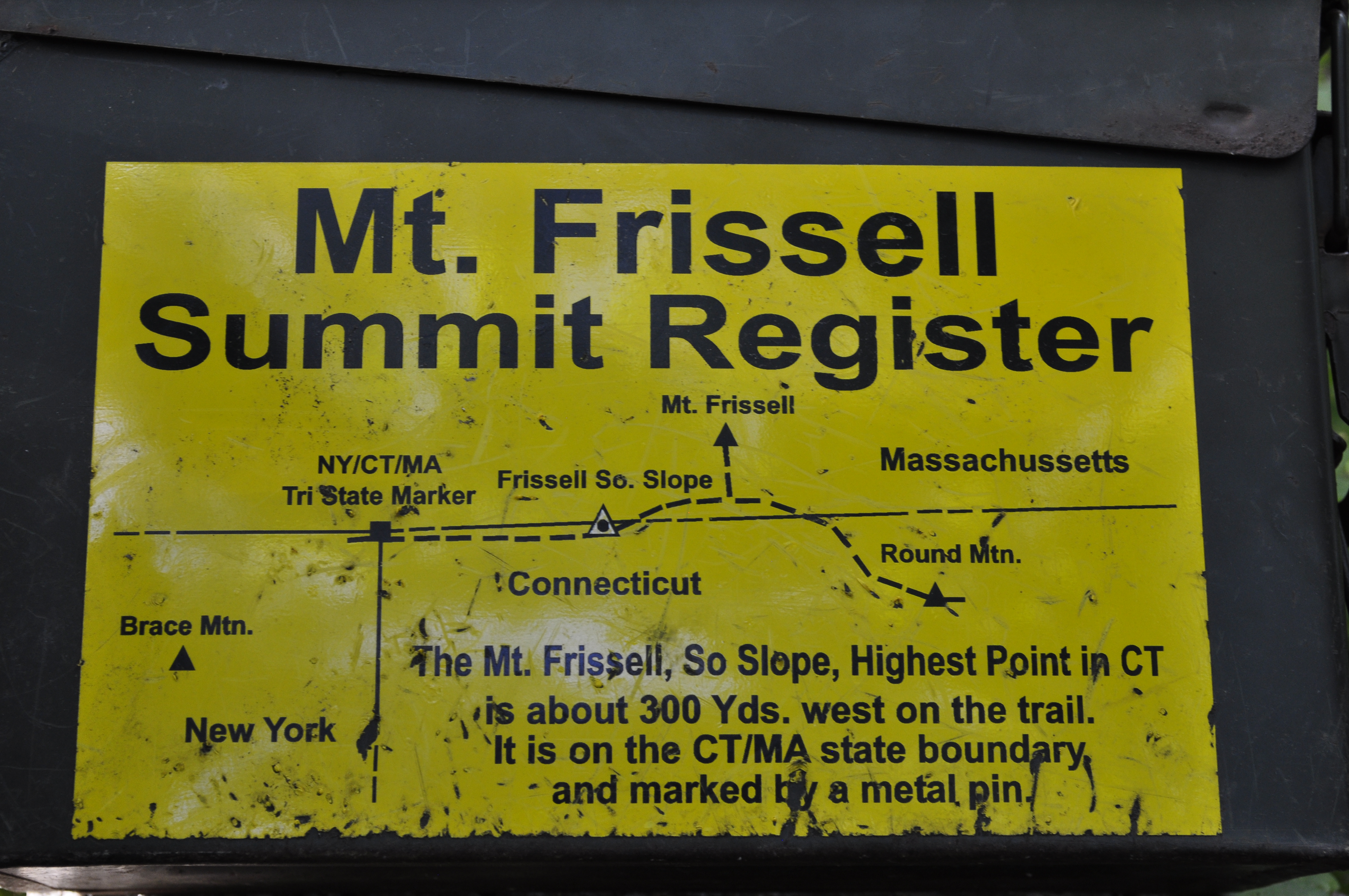
And, as American political boundaries rarely follow logical physical geographical boundaries, the result is some absurdities in state physical geography extremes. Recently, I spent a weekend exploring some geographical oddities near me; in particular I went to Mount Frissell, a mountain in Massachusetts which oddly enough is also the highest point in Connecticut.
What drew me to this particular non-descript mountain in the extreme southwestern corner of Massachusetts? Well, it was a form of geographical tourism known as highpointing. Simply put, highpointers are people who try to reach the highest point in each state or region. Now personally, I had previously climbed the tallest mountain in a few states before, but I had never really made highpointing more of a goal until I picked up a guidebook of state highpoints at a library used book sale last year. Being somewhat of a geography nerd, I thought it would be a fun travel project to undertake (at least to all the highpoints in which ropes and glacier travel are not required!)
And hence I learned about Mount Frissell. Though the mountain has its own scenic merits and was quite a lush walk through the deciduous Connecticut uplands, I would have had incredibly little reason to ever visit otherwise.

Mount Frissell
My approach to Mount Frissell came from the Connecticut side of the mountain, where an inconspicuous town road out of Salisbury eventually leads to the trailhead destination. I drove northwards out of town, up a narrow dirt road lined with verdant shrubs and trees. Immediately after hitting the state border marker with Massachusetts, I was at the trailhead. Oddly enough, I would not enter Connecticut on this trip again until I emerged at its state highpoint!
The trail to the summit begins deceptively flat and effortless. A quarter mile in, though, as East Coast trails are prone to do, the path shoots straight up the bedrock slopes of Mount Frissell. Fortunately, the trail was short enough, the views rewarding, and in less than an hour I was at the summit of Mount Frissell, elevation 2,454 feet.
Though I was at the summit, I still had not accomplished my highpoint goal for the day (nor was I at the highpoint of Massachusetts. That honor belongs to Mount Greylock at 3,489 feet, just a couple hours’ drive north.) Fortunately, my climbing portion was done. All I needed to do now was to descend about 300 yards down Frissell’s south slope until I reached the Connecticut border.
A rock cairn and a humble state survey marker are the only evidence that you’ve made it to Connecticut’s highpoint, a modest 2,379 feet. The area itself looks little different from the surrounding forest, and, being on a slope, the views are fairly obscured by vegetation. Nevertheless, I enjoyed being the highest person in the state of Connecticut for awhile, as I rested and perused the trail register notes left by fellow highpointers.
For geography bonus points, continue walking west on the trail for a few more minutes. Soon you will come upon the tri-state boundary for Massachusetts, Connecticut, and New York. As you stand there deep in the woods, maybe you’ll wonder to yourself ‘why in the world did people bother to put this giant stone obelisk in the middle of the forest?’ Well, that’s geographers for you.

The New York, Connecticut, and Massachusetts Tri-State Boundary
Other nearby state superlatives of note: Bash Bish Falls, measuring nearly 200 feet in a series of separate cascades, is Massachusetts’s highest waterfall. Well worth the visit.

Bash Bish Falls, Massachusetts’s Highest Waterfall
