Category Archives: Nature

Chasing Light

It seems I’ve been chasing light lately. First an Austral Summer below the Antarctic Circle. Then a Boreal summer above the Arctic circle. In a few day’s time, shortly after the autumnal equinox has ushered in fall to the northern hemisphere, I will board a plane and fly back to the southern hemisphere for the start of spring. I seem to have become a season hopper.
With three summers in a row without a winter season in between, you’d be forgiven if you thought I was chasing warmth and sunshine instead of chasing daylight. Though astronomically speaking, the seasons have been summer, traditional ‘summer’ weather has been neither what I was seeking or have experienced. Last December I spent the solstice in Antarctica, though even the peak of summer there felt climactically akin to my brethren at home in the Midwest. This June, I was in northern Alaska for the solstice. Yes, temperatures could rise and be unbearable under the full, circling, blazing sun—but it could also become cloudy and reach temperatures within the range of snowfall. Indeed, though the daylight has indicated summertime, these summer seasons haven’t always seemed particularly ‘summery.’
And here I go again, back to New Zealand, back to the southern hemisphere, and back into another summer season. It wasn’t by design that this happened—circumstances and the development of life decisions just produced this unintended result. While working in Antarctica last October through February, I met someone who convinced me to join her on a thru-hike on New Zealand’s Te Araroa trail. So, while the days are short and the snow falls in the northern hemisphere, I will be on the other side of the globe chasing the warmth and summer season as we hike the island together. As we follow the trail from north to south, we will be reaching higher and higher latitudes where in summer the days become longer and the nights are short.
In the temperate mid-latitudes where New Zealand lies, the distinction between periods of night and day are pronounced, but not extreme. But life, as well as the landscape, reaches towards the extreme the more one goes poleward. And beyond the Arctic and Antarctic circles, the land goes from 24-hour sunlight in the summer to 24-hour darkness in the winter. The polar regions are places of extreme seasonal differences. The summer season knows not the winter season, and the transition between the two is abrupt with only truncated springs and falls. From the sun circling overhead continually in the summer, there is only a short transition until the suns sets and never peaks above the horizon in winter.
I have seen firsthand the way the sun wanders aimlessly around the polar summer sky, circumambulating. At McMurdo Station, Antarctica, 77.5 degrees south, I spent 118 days without a sunset. When it finally did occur, the first sunset of the fall was a momentous occasion. The residents of McMurdo piled outside to watch as their faithful sun companion dipped briefly below the horizon, only to rise less than an hour later. And though the sun had officially set, it was far from night, and would be for quite some time. In the beginning of fall, the sun stays so close to the horizon that it remains civil twilight for hours after sunset. Not until a month and a half after the first sunset of the fall does McMurdo experience its first true minutes of night.

With traditional distinctions between day and night becoming muddled at the poles, day and night become somewhat irrelevant. How is one to tell the passage of time when one cannot tell when one day slips into the next? In summer, the sky remains constantly lit. Day rolled into night, but the night seemed just like the day.
In Antarctica, during the summer season, I ended up working the night shift at McMurdo Station. Though the 24-hour clock that the research station ran on considered the shift to be ‘nighttime’, there was no darkness. The only indicator of night was that the throngs of researchers and science support staff hanging out in the galley would slowly subside; there would be a few hours of peaceful quiet while the station slept, until folks began to roll into the galley for coffee and breakfast at the start of another workday. Meanwhile, in those quiet hours in the wee of the morning, the sun was at its lowest angle on the horizon, sending in radiant beams of light through the bank of galley windows—a middle of the night golden hour.
I had no problem adjusting to working the night shift after spending my first few weeks on station as a daytime worker—the sun was as bright as always, and I did not feel like I was sleeping away and wasting daylight as I had felt when I worked overnights for big-box retail. Inside my windowless McMurdo dorm room, the lights were always off. When I needed nighttime, I could retreat to my room and sleep soundly out of the sun. But were I to choose to go out and play instead, the sunlight would be my constant companion.
I had more experience living under the midnight sun this summer, as I led a 50-day backpacking trip north of the Arctic Circle to Alaska’s Arctic National Wildlife Refuge. Our latitude was not quite as high as McMurdo—only at 69 degrees latitude—thus the extremes of sunlight were not as pronounced. But what this trip to Alaska lacked in sheer latitude, it made up for in intensity of experience. Gone were the modern conveniences of McMurdo Station. There was no longer any indoors to hide in, no eternally dark dorm room or dimly-lit dark bar to retreat to. Instead, we were out in the backcountry with no more than we could carry upon our backs. Our only shelter was a thin-walled tent, and the daylight filtered right in. We either made friends with our eyemasks, or we learned to sleep in the light. Once again, the time of day became irrelevant—there was no hiding from the constant presence of the sun.
It took a number of days before I lost the nagging feeling that comes after looking at the late hour on my watch and feeling the pressure to get a hustle on to make camp before darkness falls. Throughout the duration of the trip, I kept tabs of the time on my watch—not out of necessity, but more out of a curiosity of how our circadian rhythms were adapting. Our days slowly dragged out to be longer, as we stayed up later enjoying each other’s company and slept in longer the following mornings. Thus, we ended up being awake through the darkest hours of the day, and even towards the end of the trip after the sun had been setting below the horizon, the light remained with us. Even in the depth of night on our last day in the Wildlife Refuge, it remained light enough in the tent to read a book.
In spite of the mounting fatigue from daylight that comes with constant exposure to lightness, I appreciated the daylight as a benign and amiable companion in a remote and unfamiliar terrain. Here we were, traveling for weeks in the Arctic National Wildlife Refuge, where wolves and grizzly bears roam wild. The signs of these animals were all over—tracks, scat, kill-sites. But the daylight made the wilderness seem friendlier. All told, we saw six wolves and seven grizzly bears on the trip. Seeing the bears and watching their natural disinterested movements in the daylight provided much more psychological comfort for us than wondering if out in the darkness somewhere was a bear lurking just outside the tent.
At about the same time on the trip that I began to miss the creature comforts of home—dry feet and doorways instead of tent zippers—I also began to miss the darkness. Aside from being able to sleep better in the darkness, I began to miss darkness not for darkness itself, but for what it brings to us. The constant daylight drowns out the stars all polar summer long. I’m constantly reminded that people forget this, as I am asked quite often if I saw great stars or aurora. Unfortunately, I was able to see neither stars nor aurora, much to the disappointment of my star-gazing self. And too, having the darkness creep in at the end of the day provides a natural daily cycle of gathering in your shelter for rest. Darkness too, lends itself to gathering around a campfire for light and warmth. Though we did have a campfire on the riverbank one night in Alaska, the magic of the fire just wasn’t the same in the light hours.
As much as I began to miss the darkness, when it finally did come, it felt uncomfortable and foreign. Towards the end of our trip, the nights had been gradually growing dimmer. But right after leaving the Wildlife Refuge, we caught a shuttle ride to Fairbanks, which sits below the Arctic Circle. Darkness descended upon us as we camped in Fairbanks that night. For the first time in nearly two months, it was no longer light enough outside to walk around without a headlamp. The feeling was unfamiliar. Suddenly all the scary feelings of darkness came rushing back in that gut-wrenching primordial fear of the unknown. My how easy it is to forget what darkness is like!
This coming summer, the distinction between day and night will not be as pronounced as I hike the Te Araroa as it was when I spent time closer to the poles. The mid-latitudes will provide a kinder balance of light and darkness each day. Nevertheless, as fall and winter begin to descend on the northern hemisphere, I will once again be off chasing light.

Northern Lights, Bettles, Alaska
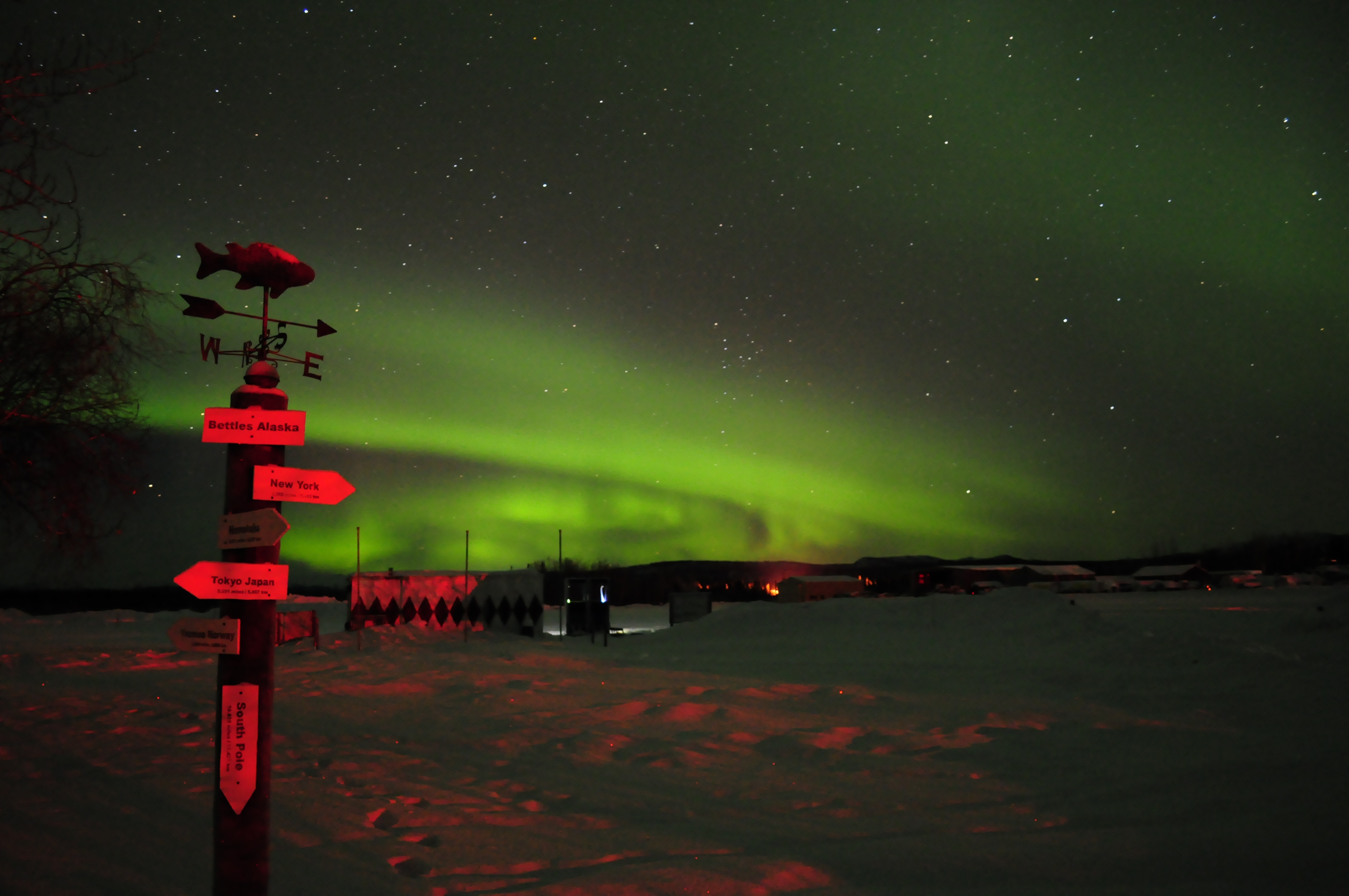
Over the winter of 2020-2021, I worked at a remote lodge 35 miles north of the Arctic Circle, in the small, isolated community of Bettles, Alaska. Located in the normally dry and clear interior of Alaska, Bettles is ideally situated under the typical arc of the Northern Lights, or, the Aurora Borealis. On any mostly clear to clear night, from late-August to early-April (when the skies get dark enough to see aurora), the vigilant observer will be treated to some degree of a show.
Though scientists who study the aurora can make forecasts and predictions about when and where auroral activity will occur, much remains unpredictable and mysterious for the aurora chaser. Each night puts on a different show. On some nights, thin distinct bands of aurora will linger in the sky for hours; on other nights, bursts of intense waves, greens and purples, will wriggle and twist their way across the sky in just a matter of minutes. Clouds or a full moon make the aurora appear vastly different than on a clear moonless night. Whatever the conditions, when the aurora do appear overhead, the viewer is guaranteed an excellent show unlike any other.
The following images and time-lapse videos I captured in and around Bettles, in the winter of 2020-2021.
An auroral forecast, along with an FAQ section about the science of the aurora, can be found at the University of Alaska Fairbanks Geophysical Institute website.
Space


Space
Space
Space
Space
Space

The Socially Distanced Cyclist: 16 Days, 1,170 Miles, and Minimal Human Contact Around the Coast of Lower Peninsula Michigan
From August 9 to 24, 2020, I took a solo, self-supported bicycle trip to explore the coastline of my home state, the great state of Michigan. Being the Great Lakes State and a water wonderland, Michigan offers 3,224 miles of freshwater coastline to explore as well as 124 lighthouses, both of which are the most of any state. The following is a summary the trip, encompassing 16 days, 1,170 miles, and following the coastline of Lake Michigan and Lake Huron around Michigan’s Lower Peninsula.
Approximate Route:

Day 1: Familiar Territory
Zeeland to Muskegon State Park: 67 Miles


It was a beautiful summer Sunday afternoon when I finally departed for my trip after a much longer than anticipated morning of final preparations. Bluebird skies and temps in the 80’s made it a day more fitting for a beach holiday than a long, sweaty bike ride. I would start the trip covering very familiar territory, a survey of the Lake Michigan beaches within just a short driving distance of where I grew up. I hopped on my overloaded bicycle and listened to the new squeaks and groans as the immense weight found its equilibrium on my old Cannondale, crossing my fingers that no spokes would snap (wanting to keep myself socially-distanced as possible, I chose to pack around 35 pounds of food so I wouldn’t need to re-provision the entire trip). My first leg would be the twelve mile distance to the white sand beaches of Holland State Park, with a ceremonial stop to see my beloved ‘Big Red’ Lighthouse, which would mark the first of many lighthouses I would stop to see on the trip.
The Holland area boasts many wonderful non-motorized recreational paths, and I followed one of them along Lakeshore Drive, past many lakeshore mansions, nearly all the way to Grand Haven. Grand Haven State Park, another beautiful white sandy beach, was packed with beach revelers on such a gorgeous day. From Grand Haven, I crossed the drawbridge over the Grand River and proceeded northward to Muskegon. This first day of the trip was marked by getting through some of the bigger metropolitan areas on the lakeshore to the less developed lands of the northern counties. North of Muskegon lies Muskegon State Park, a much quieter and forested lakeshore dune park than both of the state parks I had visited earlier. It was at Muskegon State Park where I would first camp for the night, and, as an omen for a good trip to come, I found a $20 bill on the road leading to the park.
Day 2: Storm’s A-Brewing
Muskegon State Park to Ludington: 72 Miles


Day two started fairly leisurely on the sandy beaches of Muskegon State Park, followed by a stimulating up-and down ride through the tree-covered dunes to the Blockhouse, the highest point in the park which offers great views of the dune ecosystem. Continuing northward, I followed the aptly-named Scenic Drive paralleling the lakeshore until I reached White Lake and the twin villages of Whitehall and Montague. As recommended, I found the Hart-Montague Trail, which was Michigan’s first Linear State Park and one of the earliest instances of Rail-to-Trail conversions in Michigan (1991). The Hart-Montague Trail runs for 22 miles and connects several small country towns that offer ice creameries and small cafes. Being a former railway, the trail is undeniably flat and straight, with mostly shrubs and brush for scenery. A few miles shy of Hart, I got the itch to return to the lakeshore for more expansive scenery and some hills for interest. I turned west towards the lake and the sand-buggy enclave of Silver Lake. Though I yearned to make the short detour to the remarkable Little Sable Point Lighthouse in Silver Lake, dark ominous clouds had begun building to the west.
I followed roads along the lakeshore through the city of Pentwater and past the cottages of Bass Lake. A few miles south of Ludington, the road passes right by the Ludington Pumped Storage Plant, once the largest pumped storage plant in the world! During the night, when there is excess electricity generated, the plant will pump water from Lake Michigan up into a 1.3 square mile reservoir over 350 feet above the lake. Releasing this water during the day generates supplemental electricity during peak demand. I stopped to gawk at its massive industrial workings, until a security guard came and asked me to leave. The guard said they were shutting down the overlook due to impending weather and showed me the radar on her phone. Yikes! I made a mad bike dash down from the high dunes to the city of Ludington, where I fortunately was able to set up camp before the heaviest rains set it. It was an eventful night as lightning flashed and thunder cracked overhead, but this would prove to be the only rain encountered on the whole trip.
Day 3: This is Hilly Amazing!
Ludington to Sleeping Bear Dunes National Lakeshore: 78 Miles


The storms had passed during the night leaving me with wet gear, but a warm sunny day proved to be in order once again. North of Ludington, Hamlin Lake and Nordhouse Dunes (Lower Michigan’s only federally-designated wilderness area) block road access to the lakeshore, so I took an inland route of country roads through the matrix of forest and small farms. Riding into Manistee took me back to the lakeshore, and proved to be stop with plenty of great parks to relax at along the lakefront. A few miles north of Manistee, while riding on Lakeshore Road, I got caught up in paying too much attention to a car behind me as I looked to turn left towards the beach access. My front wheel slipped off the paved roadway immediately bogging down in the soft beach sand and causing a slow-motion flip over the handlebars. Aside from a few superficial scratches on my hands, knees, and bike, I was shaken, but OK.
I continued on, albeit more wary of soft shoulders now, around Portage Lake and the small town of Onekama. Onekama is the southern terminus of Michigan Highway 22 (or M-22), that famed route whose highway sign is emblazoned on merchandise and bumper stickers all over Michigan. Reaching M-22 proved a dramatic change in riding conditions; here, the hills began. Whereas up until now things had been remarkably flat, M-22 began a series of long, winding, gradual 1-to-2 mile climbs up a sand dune, followed by a speedy descent on the other side. I maxed my downhill speed out at 39 MPH, which on a fully-loaded bicycle is simultaneously exhilarating and terrifying. I broke up the hill climbs with stops at the little Victorian town of Arcadia’s city beach, and at the much more bustling tourist town of Frankfort. I then turned my route inland toward the town of Beulah, in search of cherry pie and wine. Riding from Frankfort along the sizable Crystal Lake proved no relief from the hills, and slower travel over the terrain caused me to miss out on the treats found in Beulah. Hungry and exhausted, I made my camp for the night just a few miles to the north in the Sleeping Bear Dunes National Lakeshore.
Day 4: I Bearly Got Anywhere Today
Sleeping Bear Dunes National Lakeshore: 37 Miles


However exhausted I was from the hill climbs the day before, I woke up very excited for the route I would cover today. I would be traveling through the Sleeping Bear Dunes National Lakeshore, perhaps the most scenic stretch of land in the Lower Peninsula (indeed, Sleeping Bear was named ‘The Most Beautiful Place in America’ by ABC’s Good Morning America in 2011). My bike, however, seemed less up for the challenge. As I had feared, all the popping and groaning coming from my crank were signs that my bearings were going bad, and my crank assembly had been growing disconcertingly looser and looser since day two. I would need to make a pit-stop to have that taken care of before I found myself stranded with no pedals to pedal.
I followed the quiet stretch of M-22 into the tourist outpost of Empire, where I met up with the Sleeping Bear Dunes Heritage Trail. This trail winds through the woods through most of the park, providing most excellent riding scenery. The trail also goes over some very steep dune sections and around some very sharp curves which makes for a sendy route to keep riders on their toes. Highly recommended is the Pierce-Stocking Scenic Drive, which winds a course of seven miles over some of the biggest dunes in the park and past some of the best vistas of Lake Michigan on top of the 400-foot tall sand dunes. Unfortunately for me, and maybe fortunately for my bike, the Pierce-Stocking drive was closed in 2020 due to road construction. However, a short distance north is the epic ‘Dune Climb’, a large active dune blowout that guests are encouraged to climb. The vantages from the top are quite spectacular, and offer sweeping vistas of Lake Michigan, the dune systems, and the valleys inland. Sleeping Bear Dunes also offers opportunities for history hounds as well. Just north of the dune climb is Glen Haven, a former fishing company town that the National Park Service now maintains as a historic village. Tucked in pockets around the park are also the barns and farmhouses of homesteaders of yore. In the course of time, most homesteads folded in the region, and the main economic driver switched to tourism.
I finally stopped to have my bike repaired in Glen Arbor, and the mandatory afternoon of downtime was well spent enjoying a swim in the crystal blue waters of Lake Michigan, as well as doing some tourist shopping in Glen Arbor itself. Not a big day distance-wise, but one of the best places just to enjoy some time in the splendid destination.
Day 5: Up and Down on Leelenau
Leland to Traverse City: 84 Miles


Back in 2012, I had taken a short bike vacation with my parents to the Leelenau Peninsula, and this area offers so much for the bicycle tourist on shorter trips as well as longer ones. The bigger towns of Leland, Northport, and Suttons Bay all offer their own vibe and tourist amenities. I started my day by following M-22 into Leland, of which any stop requires a mandatory visit to the historic and artsy Fishtown. A pleasant and lightly-trafficked ride north on M-22 took me to the quiet town of Northport. About an 8 mile ride north of Northport, past many cherry orchards, I reached the very tip of the Leelenau Peninsula which is home to a state park and the impressive Grand Traverse Lighthouse. The lighthouse was open to tours, though the tower was closed due to COVID.
On my way south on M-22 towards Suttons Bay, just past Omena, I crossed over the 45th Parallel (I had actually crossed over it earlier in the day between Leland and Northport), which, being the geography nerd that I am, necessitated a reason to celebrate. The closer I got to Suttons Bay, the more traffic M-22 picked up, and the worse shape the road became. Though riding M-22 next to Grand Traverse Bay was scenic, I was happy to beat the traffic by picking up the TART Trail (Traverse Area Recreation and Transportation Trail) going into Traverse City. Being the ‘Cherry Capital of the World,’ I biked past many cherry and fruit orchards on my way into the city.
Day 6: On a Mission
Old Mission Peninsula to Charlevoix: 78 Miles


The start of the day would take me onto the Old Mission Peninsula, the very long and narrow stretch of land that neatly divides Grand Traverse Bay in two. I peddled up the Peninsula on the west side’s Peninsula Drive, which offers a very quick and flat route to the tip, going past miles of miles of really fancy waterfront properties along the way. At the tip of the Old Mission Peninsula lies the Mission Point Lighthouse and a nice beach with crystal clear waters. The route back to Traverse City, along the main highway M-37, offered quite a contrast to the solitude and ease of Peninsula Drive. M-37 goes through the middle of the Peninsula, meaning the road goes up and down many hills as it winds its way mostly through vineyards. Though the hills were challenging, they did provide some incredible vistas of vineyards and Grand Traverse Bay. Had it not been before 10AM, I would have stopped for a tasting.
Once back into Traverse City, I caught the TART Trail to its eastern terminus in Acme, a few miles away. I was glad to avoid the heavy development and tourist traffic along that stretch of US-31. Once the path ended, I followed the signed bike route through some bucolic country acres until I ended up at US-31 again. During route planning, I had wanted to bike that stretch of US-31 as it passes on a narrow strip of land between Lake Michigan and both Elk Lake and Torch Lakes. In hindsight, this was the only section of my route that I wish I had changed. US-31 along that stretch has only a narrow, crumbling shoulder, and the summer tourist car traffic is constant. Even worse, the route has absolutely no views of any lake along the way. As a plus side, though, the heavy tourist traffic does bring with it an abundance of roadside food, fruit, and sweet stands, and Elk Rapids makes a nice town to stop at. Given that it was an exasperatingly hot and sunny day, I made my fill of stops along the way to replenish my belly and refill my electrolytes with some pasties, pastries, and apple cider.
Day 7: Through the Tunnel of Trees
Charlevoix to Cross Village: 81 Miles


Whereas the previous two days were spent biking around the Grand Traverse Bay, today I would bike around the Little Traverse Bay. First stop of the day was in the harbor town of Charlevoix, outside of which I picked up the Little Traverse Wheelway bike path. With the underlying bedrock of the region being limestone here, I made several lengthy stops along the lakeshore to try my hand at fossil hunting. Being so close to Petoskey, I was really hoping to find a stellar specimen of the city’s namesake and Michigan’s state rock (even though Petoskey stones are indeed a fossil, they are not Michigan’s state fossil). Alas, good specimens of Hexagonaria coral (AKA Petoskey stones) were difficult to find, but it doesn’t take an expert paleontologist to soon pick out many other fossils in the mix; fossilized horn corals, bivalves, brachiopods, and crinoids all make the lakeshore a Devonian paleontologist’s playground. Following the nicely-paved Wheelway around Little Traverse Bay will take you to the towns of Petoskey and Harbor Springs, both of which offer plenty of dining and shopping amenities. Petoskey offers a large historic downtown area built into a hillside, whereas Harbor Springs caters to the yacht club upper-crust.
Past Harbor Springs, following Michigan Highway 119 (M-119) is both the motorist and cyclist eye-candy route known as the ‘Tunnel of Trees’. The Tunnel of Trees is a splendid, curvy, 1 1/2 lane highway that encourages you to slow down and enjoy being immersed in the trees as the highway meanders along a sand dune bluff for nearly 20 miles. Traveling, as I was, on a mostly cloudy evening, I encountered very little auto traffic (I let my eyes wander once again, forgetting entirely my days-earlier episode of crashing my bike). At the northern end of the Tunnel of Trees is the tiny settlement of Cross Village, most notably known for its iconic roadhouse, the Legs Inn. In the 1930’s Polish immigrant Stanley Smolak, along with the help of local Odawa craftsmen, began to build the fantastical building using local stone and driftwood. It is highly recommended as a place to eat, or at least walk in and feast your eyes on the décor. Wait times often exceed one hour. Though a hot meal and a beer sounded nice after such a long day, I was burning daylight and had to get to my campsite near Wilderness State Park.
Day 8: In the Straits, not in dire straits
Wilderness State Park to Mackinac Island: 45 Miles


Wilderness State Park is a fantastic, remote expanse of land on the northwest tip of lower Michigan. It offers wide swathes of pine forest and vast expanses of sand dunes, and is highly recommended to spend a full day there. My time in Wilderness State Park would prove eventful. I had just started biking for the day when I came around a corner and saw two young men frantically waving for me. I caught glimpse of a motorcycle stuck under a truck, which is what they were making a big fuss about. I stopped to help the two guys, both named Tyler, incidentally, to get the motorcycle out from under the truck. By that time, I had already pieced together the narrative that the man with the fresh patches of road rash had lost control of his motorcycle going around the curve, and had slid under the parked truck. Fortunately everyone was OK, and I helped Tyler clean up his road rash a bit. Of the three of us there, only my flip phone had cell service, and I stayed with them until they arranged a tow. Flip phone for the win!
Since I no longer had time to explore the vastness of Wilderness State Park, I picked my way along rough rural roads in Emmet County towards the very tip of the Mitt at Mackinaw City. Along the way, however, I couldn’t resist stopping when I saw a sign for the McGulpin Point Lighthouse (which, by the way, you could actually climb the tower). From the McGulpin Point light tower, I could get a great view of the Mackinac Bridge spanning the Straits of Mackinaw. I was at the tip of the peninsula, but the Mackinac was a bridge I would not cross (at least not on this trip). Nearby the lighthouse is the Headlands International Dark Sky Park, and the region is perfect for stargazing on a clear night.
Now that I was halfway through my ride and at the tip of the Peninsula, my crowning stop would be an afternoon spent on Mackinac Island, Michigan’s iconic and premier island destination. A former British fort and a tourist destination since the mid-1800’s, Mackinac Island was once even briefly a federal National Park (1875-1895). Today, the island is known for its bikes and horse-drawn carriages, its Victorian architecture, its fudge and tourist shops, and for being carless. It is a half-hour ferry ride to the island from Mackinaw City, and to get to the ferry terminal you have to pass through all the shops of downtown Mackinaw City that are hawking fudge and T-shirts. Once you land on Mackinac Island itself, you’ll be in downtown and will walk past all the shops hawking the same fudge and T-shirts as the mainland. But when you’re on the island, it’s special, and I did the touristy thing of buying fudge, popcorn, and postcards. The island is also great for history buffs, given Fort Michilimackinac and other historic buildings to tour, but I was there for the bike riding. A right of passage on the island is to bike the 8 mile loop on M-185 that rings the island. I had biked around the island once before on a family trip when I was in fifth grade, but biking on my own as an adult was so much better. Of course I had to make a stop at some of the iconic geological formations such as Arch Rock and Skull Cave. And there was no better way to cap off the day than by getting ice cream from the shop below the Grand Hotel’s world-record 660′ long front porch.
Day 9: Lonesome Limestone Highway
Mackinaw City to Thompson’s Harbor State Park: 74 Miles


United States Highway 23 offers a dramatic contrast to the commercialism of Mackinaw City. Never before had I been to northeast Lower Michigan. It is an region of small towns separated by large distances all built on the extractive industries. From Mackinaw City to Cheboygan, the North Central State Trail follows an old railroad grade paralleling Highway 23. Though the crushed gravel of the state trail was nice, I found I preferred the feel of pavement and the glimpses of Lake Huron that riding on the road afforded me. Traffic was light and the shoulders were wide, which meant great riding conditions.
The surrounding waters of Lake Huron are extremely treacherous, and have claimed hundreds of ships and lives over the centuries. These shipwrecks are all protected within the Thunder Bay National Marine Sanctuary. Forty miles from the Straits of Mackinac is the Forty Mile Point Lighthouse. Several shipwrecks lie in shallow water just offshore, but the remains of the 1905 wreck of the J.S. Fay lie on the beach near the lighthouse. Snorkeling, SCUBA diving, kayaking, or glass bottomed boat tours are all the best ways to see the wrecks.
From Forty Mile Point, one can get on the paved Huron-Sunrise Trail, which leads to Rogers City. Though Rogers City is small, its status as the only town of 1,000 or more people for 30 miles in either direction means that it has all the amenities a person would need. Rogers City is built on mining—mining the fossil-rich limestone bedrock that dominates the region. The limestone is crushed and used as an ingredient in cement, and Lake Huron provides easy access for shipping to distant markets. Outside the city is a special overlook that peers into the massive strip mine that gives Roger’s City its lifeblood. The Calcite Quarry, at over 1,800 acres, ships out 7 to 10 million tons of limestone each year.
Leaving Rogers City early in the evening, the sun was beginning to shine lower and lower on the horizon, while the blue open skies made the late sunshine feel quite tangible. I took a detour off of US-23 at Thompson’s Harbor State Park to search for the Presque Isle Lighthouses. Without directions or a detailed map, I followed an unnamed dirt road hoping it would take me to the lighthouses. The road dead ended at the outlet where water from Grand Lake flows into Lake Huron. The low gleaming sun, the slight warmth in the gentle breeze, the sound of the rocks rolling in the surf—it aligned all too perfectly. I had to stop right there for the day—I had to sit down and just bask in the beauty of the experience. If anything, that evening spent on the beach of Thompson’s Harbor was the defining spiritual experience of the trip. The video encapsulating my experience is included above.
Day 10: Here On Huron
Thompson’s Harbor State Park to Oscoda: 76 Miles
")


After my euphoric evening at Thompson’s Harbor State Park, I had to follow up with nothing short of a pre-breakfast swim in Lake Huron. My morning route would continue around Grand Lake to the small sleepy enclave of Presque Isle. I would find both the old and the new Presque Isle Lighthouses on a peninsula, and, not unexpectedly, both were closed for the summer. Nevertheless, taking the detour around Grand Lake to those small communities and idyllic harbors was well worth it. After passing another large limestone quarry, I reconnected to US-23 and had a short ride into the city of Alpena.
Alpena hails itself as the ‘Sanctuary of the Great Lakes’ owing to its location at the center of the Thunder Bay National Marine Sanctuary. It is a large city, as far as cities in northeastern Michigan go, and along with the extractive industries of fishing, lumbering, and limestone quarrying, Alpena boats a modest maritime tourist economy as well. Unfortunately the highly acclaimed NOAA Museum and adjoining glass-bottom boat tours were closed due to COVID. At this point in the trip, I had grown terribly tired of the food I had packed from home, so I stopped in downtown Alpena to get the greasiest cheeseburger Alpena could offer. While seated at the restaurant, a middle-aged couple started up a conversation by saying that they had seen me yesterday riding from Mackinaw City. We chatted a while about our Michigan travels, and they seemed thoroughly impressed by my stamina. They also paid for my meal.
I left Alpena headed south on US-23 on the mostly empty road past the endless forest. A peculiar place to stop would be Ossineke, where giant sculptures of Paul Bunyan and Babe the Blue Ox great travelers on the highway. Nearby, a gigantic Jesus holding the earth aloft in one hand beckons visitors to come visit the Dinosaur Gardens Prehistoric Zoo, an eclectic and anachronistic mix of cavemen, dinosaurs, and Christianity. By the time I was ready for a break, I was passing by the small town of Harrisville, and I saw a sign for an outdoor concert at the lakefront pavilion. It was some good foot-tapping folk music being played, and after a few songs an announcement was made that it was the organizer of the concert series birthday today. A homemade carrot cake was cut up to celebrate. I was invited by a women to grab a slice. What great small-town hospitality! South of Harrisville, US-23 travels right next to Lake Huron, on what is called the ‘Sunrise Coast’. In a long stretch from Harrisville to Oscoda, the lake is lined with second homes and vacation rentals. I think I finally found where most of the east-siders go on their summer vacations.
Day 11: To the Thumb Pit
Oscoda to Standish: 71 Miles


The twin villages of Au Sable and Oscoda mark the finish line of one of Michigan’s most epic races: The Au Sable Canoe Marathon. In the race, competitors start 120 miles upstream in Grayling, paddling through the night to reach the finish line near Lake Huron. The race was cancelled in 2020, but seeing so many fine rivers as I biked along the coast made me itch to get out and paddle again.
A short distance later, I would be coming upon the start of the ‘Thumb Pit,’ better known as Saginaw Bay. The Tawas Point Lighthouse marks the start of the bay on the northern end, and Tawas City is a small tourist enclave. Continuing south on US-23, the highway is flat and runs right along the lakeshore. The tourist resorts and second homes disappear, and the landscape consists of forest and utilitarian buildings. Maybe it was something about this road, or maybe it was because I just started to put my head down and ride, but I began to notice an abundance of quarters, nickels, and dimes scattered on the shoulder. Another roadside find was a ‘Don’t Tread On Me’ flag, which was evocative of the region’s independent and libertarian leanings.
Day 12: Thumbs Up
Standish to Port Austin: 77 Miles


Today I would round Saginaw Bay and enter Michigan’s Thumb. Pure geographical curiosity had me wondering what it would be like to visit, though I have heard that the Thumb is very flat, rural, and agricultural. The rumors proved true: the Thumb is incredibly flat, rural, and agricultural. Very small farm towns dot the landscape. Biking south on M-13 going into Bay City, I passed through Pinconning, Michigan’s Cheese Capital. On the Thumb, the town of Sebewaing has a large sugar beet processing plant. It was not until the very tip of the thumb, in the towns of Caseville and Port Austin, where vacation homes and tourist attractions began to sprout up along M-25 by the lakeshore. The thumb-tip also offers a couple of nice state parks with sandy swimming beaches.
Day 13: Last Day Along the Lake
Port Austin to Lakeport: 84 Miles


Starting from the tip of the Thumb, today would be my last day biking along the lakeshore as I made my way south on M-25 towards Port Huron. M-25 runs right along Lake Huron, passing many small towns along the way. Even though the route is right next to a Great Lake, it remains agricultural and undeveloped. I biked past the historical company town of Huron City and then past the Point Aux Barques Lighthouse and former U.S. Life Saving Service Station. I continued biking past many sleepy towns enjoyed by the R.V. crowd, until I passed through more touristy enclaves like Lexington and Lakeport as I neared Port Huron.
Day 14: Eastward
Lakeport to Flint: 96 Miles

Alas, all good things must come to an end, and I was about to wrap up my travels along the Great Lakes and start the long trek eastward back to my starting point in Zeeland. I couldn’t help but say goodbye to Lake Huron with one final swim at Lakeport State Park. From Lakeport I would pedal eastward through the farm country in the heart of the state. I passed through small towns named Yale, Lynn, Capac, and Dryden. The roads were rough and had limited shoulder, and I bet that road bikers are a rare occurrence there. However, even with the unseemingly busy roads and all the trucks trying to get past me, every driver was courteous. By the time I biked to Metamora and Hadley, the farmland had turned to hills and forest. I would end the evening on the outskirts of Flint, after a very long, hot and sunny day.
Days 15 & 16: Wrapping Up
Flint to Middleville to Zeeland: 115 & 35 Miles

One final, scorching hot day was ahead of me as I aimed to make it to my friends Robert and Becky’s house in Middleville for the evening. From the outskirts of Flint, I was immediately back into farm country. I would pass through Durand, home of the Michigan Railroad Historical Museum. I would also pass through Laingsburg, where I began running into fleets of spandexed cyclists out for a Sunday morning ride. Out of Laingsburg, I would follow country roads that ran along the crisp and cool Looking Glass River, being thankful for the trees lining the road that provided some measure of relief from the sun. Once past the outskirts of Lansing, it was all sun-beaten farmland until Middleville. Wanting to avoid traffic, I wandered down country roads, meandering generally East and South towards my destination. While I succeeded in avoiding traffic, I also never ran into the gas station that I had optimistically been counting on to replenish my desperately low electrolytes. By the time I arrived at Robert and Becky’s house, it was well past sunset. An incredibly long day, but one the prospect of seeing old friends again had motivated me on towards.
From Middleville, it was a chip shot of a day to finish the remainder of the trip back to Zeeland. More meandering and country roads, and the unanticipated stretch of country gravel, but 35 miles later I had made the trip complete.

Seeking Spring Ephemerals
Exploring Van Raalte Farm, a local Holland, Michigan Park
In early spring, well before the trees and shrubs send forth their leaves into the skies above, a fleeting class of plants emerges from the ground to live their brief, wonderous time in the unhindered spring sunlight. These flowers speckle the forest floor with patches of bright whites, yellows, purples, and reds, atop their brilliant fresh green foliage, in a welcome contrast to the subdued hues of winter. The ephemeral show lasts for a few short weeks before the flowers fade away and the lush greens of the plant wither away to wait the remainder of the year hidden secretly underground. In May 2020, I went off as a flower-hunter, spending time scouring a few local parks and preserves in the greater Holland, Michigan area, looking for native wildflowers. I found some ephemerals in bloom, was too late on others, but everywhere saw a diversity of early-blooming wildflowers. I encountered a much greater floral diversity than I could reasonably post here—so get out to your local parks and go seek your own wildflowers!


A sure sign of spring in the forest are the large brilliant blooms of the Trillium (Trillium grandiflorum) Melantiaceae. Single stalks with leaves of three and flowers with petals of three (it is the TRI-llium, after all). The showy white flowers gradually turn to pink.


A personal favorite of mine is the swaths of Trout Lilies (Erythronium americanum) Liliaceae that blanket the forest floor. Bright yellow lily-like flowers nod from a stalk that emerges above their one or two leaves. Brown mottling on the leaves is said to resemble the skin of trout, giving rise to the plant’s common name. Their peak bloom in West Michigan is in April, but I was fortunate to catch a few late flowers in May.


Forming dense clusters of large, deeply-cleft umbrella-like leaves is the Mayapple (Podophyllum peltatum) Berberidaceae. The fleshy stalks emerge in April, and a single white flower blooms in May. The ‘apple’ that gives the plant its common name (also called a ‘forest lemon’) does not ripen until June, and all green parts of the plant, including the unripe fruit, are poisonous.


Found abundantly in wet, marshy areas is the aptly-named Marsh Marigold (Caltha palustris) Ranunculaceae. This bright-yellow flowered plant grows in colonies and steadily blooms from April to August.


Another bright yellow flower, although this one with only a single bloom and being found in more upland the woods is the Hispid Buttercup (Ranunculus hispidus) Ranunculaceae. The word ‘hispid’ means covered with stiff hairs or bristles, and references the flowering stalk of the plant.


Dense colonies of 5-sepaled flowers growing up to one foot high in woodlands is an indicator of the False Meadow Rue (Isopyrum biternatum) Ranunculaceae. A true spring ephemeral, False Meadow Rue blooms for only a few weeks in May, then completely withers away to its roots.


Another flowering plant of moist woodlands, this one purple in color, is the Wild Geranium (Geranium maculatum) Geraniaceae. The geranium is popular with gardeners, and several domesticated varieties can be found in cultivation.


An incredibly brilliant and uniquely-shaped flower is found on the Wild Columbine (Aquilegea canadensis) Ranunculaceae. Several flowers, with five red-spurred petals and protruding yellow stamens, hang from the plant above its deeply lobed leaves. Nectar is stored in the flower’s spurs, providing food for pollinating hummingbirds.


Multiple globe-shaped clusters of tiny white flowers emerging from a single stem on the forest floor indicate Wild Sarsaparilla (Aralia nudicaulis) Araliaceae. Not far from the flowering stem are the leaves of plant, deeply divided into typically 5 leaflets. Young Wild Sarsaparilla with three leaflets and a glossy purple hue can sometimes uncannily resemble poison ivy. The roots can be used as a substitute for real Sarsaparilla flavoring, though the plant is not closely related to the True Sarsaparilla (Smilax sp.) of tropical climates.


A single palm leaf-like plant with a spiked cluster of small white flowers is the False Solomon’s Seal (Smilacina racemosa) Asparagaceae. It grows in the same habitat as the true Solomon’s Seal (Polygonatum sp.), which will have several bell-shaped flowers hanging under the stem. The origin of the common name ‘Solomon’s Seal’ is unclear, though it was perhaps named in reference to the plant roots resembling a signet ring or Hebrew characters.


Not only were the wildflowers blooming, but some trees were in bloom too. I came across this small native understory tree, the Eastern Redbud (Cercis canadensis) Fabaceae. The Redbud blooms profligately with bunches of pink flowers, making it no wonder it is popular as a landscape tree as well.

Showing promise of fruity treasure to come in June is this diminutive white flower, Wild Strawberry (Fragaria virginiana) Rosaceae. Wild strawberry plants sprawl across sunny open patches by spreading with runners. The thimble-sized strawberries are juicy and flavorful, and are quite popular with this flower-hunter.
The field guide I used in identifying these plants was Newcomb’s Wildflower Guide © 1977 by Little, Brown and Co.
Hi!

A Royal Walk: Hiking across Isle Royale
The Sun Rises Over Isle Royale
It was the middle of May 2018 when I first landed on Isle Royale. That storied island—that mass of rock isolated in northern Lake Superior. So far away it seems logically like it should be part of Canada, yet it belonged to Michigan—the only National Park in my home state. The mystery of that island beckoned me from maps with its geography and isolation. Long had I wanted to discover what this coveted gem had in store.
At long last, I finally visited the island after spending a winter and a spring teaching environmental education in northern Minnesota. By that time, I had become quite familiar with the boreal northwoods from all those hours teaching kids in the wilds. The northern forests, hence, were not all that different from my everyday existence.
Given my years of anticipation, Isle Royale was bound to be something exceptionally different than what one could experience on the mainland, I believed.
As it was, my first trip to the island was a simple, short overnight stay, ferrying in from Grand Portage, Minnesota to the Windigo Visitors Center on the western end of the island. As far as landscapes go, the flat, forested, mixed-conifer forests of Windigo are not spectacularly different than the Minnesota Northwoods I had become accustomed to.
I was a bit underwhelmed.
I didn’t even bother to take any pictures (incidentally, my camera had broken earlier that trip).

Arriving at Washington Harbor at Windigo
I left Isle Royale that trip convinced that I had seen the island in the wrong way. A simple overnight trip was no way to do the island ecosystem justice. If I was ever to return to Isle Royale, I thought, I would do it in the right way: I would hike the island from end to end, slow enough to absorb the ecological transitions, to understand the essence of what makes the place, and to enjoy immersion in the vast isolation of Isle Royale.
As chance would have it, in the summer of 2019 I was selected to take part in a volunteer restoration crew on Isle Royale’s Rock of Ages Lighthouse. I would be returning to Isle Royale sooner than I had thought, and this time, I would be staying on to hike across the island afterwards.
The Rock of Ages Lighthouse
I started my hike on the western end of the Island, at Windigo, the widest part of the island. Here the forest commands the land and the coastline is smoother, less jagged. I made my way to the Greenstone Ridge trail, the hiking path that transects the middle of the island. Despite its name, the Greenstone Ridge at this point isn’t much of a ridge at all. The trail slowly climbs uphill under the cover of a mixed-forest—conifers, but also maples and even the warm-and-dry loving oaks. I spent my first night at the interior campsite of Island Mine, the site of an 1870’s copper mine that peaked and was abandoned in only a few years.

Broadleaf forests found more commonly on the western end of the island
Mining history would be a big theme of the hike, and copper was the resource of value. It wasn’t just white Euro-Americans who were mining the island either: the Ojibwe, the indigenous people of Isle Royale, had mined the island for thousands of years. Archeological evidence suggests that as early as 4500 years ago, indigenous people harvested copper by using stones to hammer off chunks of native copper from outcroppings in the bedrock. As their technology progressed, they began to mine deeper in the bedrock by building large fires over ore deposits, then quickly dousing the fire with water in order to crack the bedrock. Small indigenous mining pits can still be seen throughout Isle Royale today. By the 1840’s the Objibwe had been duped into ceding their lands to settlement and development for the resource-hungry Americans. Speculators flocked to the island to make their riches, but mining on Isle Royale was always boom or bust. Island Mine organized in 1874 and extracted over 200,000 pounds of refined copper. Three years later, the company went bust. All that remains now are scattered pieces of rusting equipment and mounds of tailings.


Day two saw me continue east along the Greenstone Ridge. After a few miles of hiking through the shady canopy, I began to get my first views from the ridge: small, rocky clearings at first with scrubby oaks and small shrubs partly obscuring the views. First the clearings were few and far between, but then they became more abundant. From the ridge one could begin to see some of the inland lakes that dot the island, including the scenic Lake Desor, near the summit of Mount Desor, which at 1,394 feet is the highest point on the island. From clearings further along I could even see Ryan Island in Siskiwit Lake, the largest island in the largest lake on the largest island in the largest lake.


With the gradual opening from shady forest to open ridge, another fun thing happened: berries. Up on the ridge, the sun beats down and the soil becomes dry. The seasons progress quicker than by the lakeshore where Lake Superior tempers the weather. Whereas the thimbleberries at lower elevations were still hard and green, up on the ridge I began to encounter a progression of ripeness: first, an isolated red berry, then a few on a bramble, and finally whole thickets of the bright red berries. Thimbleberries are a thornless, velvety cousin of the raspberry, with shallow bright red berries which are so soft and juicy that they can only survive the journey from the hand to the mouth.
After gorging myself on snacks of thimbleberries and taking a mid-afternoon swim in the cool and clear Lake Desor, I made my campsite at Hatchet Lake.
The clear summer weather finally took a turn for the wet on my second night. It was a constant heavy rain that slowly drenched me. I awoke (did I even sleep?) with about an inch of standing water in my tent. I later learned that at Windigo they recorded nearly two inches of rain in that overnight.
I would start my third day soggy. Today I would be leaving the Greenstone Ridge trail for the north shore of Isle Royale and the infamous Minong Ridge. I reached Lake Superior at Todd Harbor, a picturesque cove with a mélange of water-smoothed rocks. I took a short side hike to the former open pit of the Haystack Mine, and then followed a trail just a little bit further to find a small waterfall that was the cause of some bubbling noise off in the distance. From Todd Harbor I took the Minong Trail towards McCargoe Cove. The Minong Trail, though it never reaches as high elevations as the Greenstone Ridge, deserves its reputation as a knee-destroyer. The Minong Ridge is a series of exposed escarpement ridges: a rocky, uneven gradual climb up the bare basalt, followed by a steep dropoff on the backside. Then repeat, again and again. On a hot day, it wears you out, as it wears out your knees.


I reached the deep and slender McCargoe Cove by mid-afternoon, and after such a soggy night, I was eager to rest and dry out. This afternoon, I finally got a shelter at one of the island’s campsites. They are spacious lean-tos, screened-in, and with the perfect combination of both scenic views and isolation. I dried my clothes off and basked in the sun.


Though McCargoe Cove was my favorite campsite of the hike, there were not many people there at all. Isle Royale consistently is the least visited national park in the contiguous 48 states. In 2017, this National Park had only more visitors than Lake Clark, Kobuk Valley, and Gates of the Arctic National Parks, all sites in remote interior Alaska. With only 28,196 people even paying a visit in all of 2017, more people visit parks like Yellowstone in a single day than all of Isle Royale in an entire year. The great benefit of Isle Royale’s lack of popularity is its solitude. The trails and campgrounds never feel crowded. With fewer folks around, you also develop good connections with your fellow travelers quite readily. At McCargoe Cove, I spent the evening around the campfire chatting with our only neighbors: a group of fishermen from Chicago and a pair of ladies from the Twin Cities. Trail community seems to come easily here.

McCargoe Cove: Some Hike, Others Canoe
McCargoe Cove was also the harbor used for the Minong Mine, the most prolific mine in Isle Royale’s history. Like other island mine sites, indigenous people had harvested surface copper deposits here first. In 1872, modern mining operations had commenced at Minong. This mine produced some incredible finds, such as a 5,720 pound nugget of almost pure copper. Finds like this nugget, and several other massive nuggets, added fuel to the mining fire. Two shafts were dug, up to 300 feet deep, as well as several drift tunnels that followed the ore veins. As tunnels were dug, tailings, or waste rock, began to fill in the adjoining marsh that leads to McCargoe Cove. A boomtown known as Cove sprang up at Minong, housing upwards of 150 people at its peak. Along with its railroad, stamp mill, and blacksmith shop, Cove even boasted a post office. Indeed, the prospect of permanent settlement on Isle Royale seemed so promising that Isle Royale even became its own county in 1875. By 1885, however, all mining operations on Isle Royale came to a halt for good. The grade of the ore dwindled and the price of copper fell; Isle Royale proved to be too isolated and the winters too harsh. Eventually, even though over 4 million pounds of refined copper were removed from the island, all mining ventures proved too non-economical to continue. Island boomtowns were abandoned. By 1897, with no permanent population left, Isle Royale County was re-absorbed into Keweenaw County.


On my fourth day, after very much enjoying my single-night stay in the shelter, I was off to hiking again. This time I decided to traverse the island from north shore to south shore, hiking astride several interior lakes along the way. I had been told that these interior lakes were hotbeds for moose activity. As storied and prolific as the moose population on Isle Royale has been, I had yet to see my first moose on the island. I knew they’d be around, as I had already seen plenty of moose scat and browse sign.
The scenic and shapely-named Chickenbone Lake proved of no avail for moose, though it was a Mecca for giant dragonflies. The next lake over, at Lake Ritchie, I got my first far-off glimpse of a moose browsing in the aquatic vegetation far across the lake. With the gradual decline of the predatory wolf population, the numbers of moose on Isle Royale have skyrocketed in recent years, with an estimated 2,000 moose inhabiting just over 200 square miles of island (learn more about Isle Royale Wolf-Moose dynamics here). I would only end up seeing one other moose on my trip. After losing the hiking trail on some bedrock, I wound up following a moose trail into the woods. The moose trail petered away until I reached a swamp. Suddenly, a large startled moose crashed away from me through the brush!
Though I had seen two moose, as far as their illustrious predator the wolves went, I had yet to see any. When I had visited previously in 2018, there was just a pair of wolves left on the island, simultaneously a brother-sister pair and a father-daughter pair (you do the math on that inbreeding!). In the winter of 2018-2019, four more wolves were introduced to reinvigorate the existing wolf population. For anyone, seeing a wolf is a rare treat. Alas, I never had a wolf encounter on the island; the closest I got to seeing the wolves was the island cabin of well-known wolf-moose researcher Rolf Peterson.

Moose researcher Dr. Rolf Peterson’s Rock Harbor cabin
Once at the south side of the island, I camped at the large harbor of Moskey Basin. Completely different from the small, sparsely-filled campgrounds I had been staying at, Moskey Basin was filled to capacity with both families and large groups, and its vast expanses of exposed bedrock and its picnic tables made this site feel luxurious and tame. But I should have expected that, visiting in high season after all. Even in high season, though, Isle Royale is not that busy, and getting all of that wilderness ambiance while hiking was a treat not to be taken for granted.
The cove at Moskey Basin was a sight to behold—layers of exposed bedrock outcroppings running right into the water. I hadn’t noticed it too much before, but the island was becoming rockier and rockier the further I traveled east. The exposed rocks left plenty of good places for sunbathing and also proved to be a prime habitat for blueberries (thimbleberries, unfortunately, had all but disappeared after leaving the Greenstone Ridge). Also without my noticing, the broadleaf tree canopy had disappeared too. Thin soils could no longer support the large broadleaf trees seen more westerly on the island. Instead, the forest was becoming more a stunted array of firs and spruces.


With a clear night ahead looking promising, I made a commitment to staying up to see the stars. This being mid-summer in the westernmost Eastern Time Zone, the sun did not set until near 10pm, and the stars did not emerge until well afterwards. After a full day of hiking, I was usually in my tent well before the stars came out in their full glory. But I stayed up tonight and was treated to a show on an absolutely moonless night. Being miles away from any human settlements, the stars on Isle Royale are absolutely amazing!


My last day on Isle Royale would take me into the primary tourist outpost at Rock Harbor. Rather than hugging the shoreline trail to my final destination, I once again went inland to take the Greenstone Ridge home. The trail up to the Mount Ojibway Fire Tower was never too steep, provided uninterrupted views, and proved to be premiere blueberry habitat. The whole climb up I had a constant handful of blueberries as a power snack. The Mount Ojibway Fire Tower, unlike its much squatter kin at Mount Ishpeming, actually provides visitor access to the base. Climbing the tower provides views of the entire island from north to south.


The Greenstone Ridge continued its path northeast across exposed rocky and grassy balds. By the time I reached the Mount Franklin lookout, it was clear I was encountering a different area. The overlook was populated with day-tourists hiking up from their various Rock Harbor lodgings. I left the viewpoint and went on the downhill to Rock Harbor and my hike’s end. At the eastern end of the island, Isle Royale’s tilted geology splits the island into many narrow peninsulas and long bays running towards the northeast. I walked along these deep harbors right along the trails by the edge of Superior’s turquoise waters.
A sign for campsites signaled that I had made it into Rock Harbor. I could now bask in the luxuries of this tourist depot. Modern settlement at Rock Harbor started with a few unsuccessful mining ventures in the 1840’s, then moved into the realm of commercial fishing, as Scandinavian immigrants built their fishing shanties after the copper booms. By the early 1900’s, these fishermen were guiding pleasure-seekers around the island and accommodating throngs of tourists in cabins. Several resorts eventually popped up, having their heyday in the 1920’s. The Great Depression and changing societal tastes caused a drastic decline to tourism in the 1930’s. By 1940, Isle Royale had been declared a National Park, and the National Park Service began the process of buying out and shutting down the remaining tourist resorts and removing fishermen from the island. Gradually, this formerly logged, mined, and settled island would be transformed into a 99% wilderness park with no permanent population.
Today Rock Harbor boasts a store where one can buy fresh vegetables as well as craft beer, hot showers ($6 for a five-minute shower), laundry, a restaurant, rustic cabins, and even a few hotel rooms. For this wilderness traveler, it was a world apart from the Isle Royale I had just experienced. The development at Rock Harbor was a foil to the isolation of the island. Though I milled about the Rock Harbor Village for a while, it just wasn’t what I needed. I made off to a quiet edge of Lake Superior and took a long, cleansing swim in her waters. For me, that is what Isle Royale is about.

Rock Harbor Lighthouse

Nature’s First Green is Gold

Forest Path in Spring with Bright Green Trees (c) Matthias Hauser
It was an inconsequential day, about ten years ago now. A fresh, bright, day in May; the sun shining kindly and the air full of perceptible warmth for the first time since winter.
Spring fever had struck. We were a group of high school seniors, expectantly awaiting the impending days of graduation, summer freedom, and the privileges of adulthood. Academics, that lynchpin of education, were no longer the most important thing on our minds. Conversations instead turned to commencement and the life beyond. Mrs. Aupperlee’s 4th Hour AP English class reflected this sentiment: though it had been a particularly social class all year, the excitement of spring days had amplified its gregariousness.
We enter the classroom early, each filing into his or her own chosen seat to commence the pre-class banter. Fourth Hour was the last obstacle before lunch. Attention spans would wane, and the classroom atmosphere would become casual. Typically we would have to edit essays or practice for the upcoming AP exam, but our class knew what subjects to broach to get Mrs. Aupperlee off on a class-long tangent about things little related to English literature.
Today was just going to be another ordinary school day to get through, once again.
The bell rings and Mrs. Aupperlee takes attendance. Unexpectedly, she announces that everyone should get out of their seats and follow her. Today we would be going outside. We follow, through the double glass doors, out onto the lawn that surrounds the school. Mrs. Aupperlee continues on, in the bright May sunlight, to the very edge of the lawn. She pauses at a tree which, until now, none of us had ever given particular attention. Standing still to draw us in, she produces a piece of paper and proceeds to read: Nature’s first green is gold,/Her hardest hue to hold…
We listen to the poem as we stand outside. The tree’s freshly budded leaves wave golden in the light breeze. Some of us notice this, as the verses of poetry glance past our ears and the wind tussles our hair. Yet, standing there, some of us also wonder inaudibly why we came out here today. The poem was simple enough. Was the arboreal visual necessary to understand Robert Frost’s words? Isn’t it more expedient to just read poetry indoors? And who even really cares about looking at trees anyways? Our English class, to this point, had only been taught in a classroom. And besides, what even did Robert Frost have to do with our curriculum at the moment? Personal erudition, as lofty as it may be to high-minded intellectuals, has little to do with the forthcoming world of AP Essays and standardized tests. Why were we spending our class time this way?
As that high-schooler, I can’t recall exactly what I was thinking in that specific moment. Being the ambitious, productivity-minded student that I was then, I was likely questioning the value of walking around outside during class period. I had enrolled in this course, after all, primarily because it was an additional AP credit, and not from an inherent love of literature or poetry. English was one of those necessary evils of high-school education, one I had long endured with much chagrin. My future, too, was headed in a different direction; I had been accepted into an engineering program in college already. I expected AP Literature to be my final English class and that I would leave writing behind altogether. I saw little need then for the frivolities of poetry.
And now here I am ten years later. Though the particular details of what I thought on that late May morning have distinctly vanished from memory, our class’s spontaneous visit to the budding tree, along with the poem we shared, still remains clear. In retrospect, all the other things that I thought relevant and important ten years ago—homework assignments, AP test scores—are now antiquated and defunct memories. What remains with me now is the fact that we did go outside and that we did read a poem while crowding a tree. That single small classroom exercise, though it lasted just a few trivial minutes in duration, was influential enough to hold fast in my memory even a decade later.
From time to time, I find myself pulling out that memory, particularly when the first leaves of spring emerge. Without much conscious thought, I’ll suddenly be quoting Robert Frost, if not to my traveling companions then internally to myself: Nature’s first green is gold…
In the ten years since high school, I have changed substantially from the person who I thought I was then becoming. It was small events like reading the poem by the tree that slowly molded me into the person I would become. There was no way I could have realized it at the time, since the poem had no immediate impact on me. However, the power of the poem shared by the tree would lay latent in me for years, until, slowly, it would compound with other life experiences until I realized just the direction I had been traveling in and the person those events had been shaping me to be.
In part, thanks to that high school English class, I take notice of the trees now. Whereas before trees to me were mere background scenery, common and forgettable, I now take notice of their delicate intricacies. The changing of the seasons has become vitally important to my inner well-being, and poetic works like Frost’s serve as reminders to pay attention to the daily acts of beauty that are occurring all around us. I now can’t see the first leaves of spring without also thinking of Robert Frost.
In the time since high school, I have also found my niche in the work of environmental education. My primary occupational duties fall along the lines of educating and exposing individuals to the outdoor world—biological, geological, ecological. To those who I instruct, I primarily give facts and explain complicated ecological interrelationships in the most scientific sense. But more than just a rote recitation of facts, I aim to use my capacity as an educator to teach people a new, ethical perspective of how we relate to the natural world just as how we relate to each other. In my job duties, I now take individuals outdoors to different environments—to the world outside of the classroom where didactic instruction may not be as practical but the lessons learned become all the more memorable and valuable.
As I have now become an educator myself, I think back to the point that Mrs. Aupperlee was trying to impress upon us by taking her 12th grade English class outside on that May morning. More than teaching us facts about grammar or even exposing us to a new poet, I now believe that Mrs. Aupperlee was teaching us something of higher accord. She was trying to affect our ethical bearings, educating us to be observant, to notice things, to be citizens of the world. Inevitably, facts fade. But who we are remains. That day, on the lawn surrounding the tree, ours was not a factual lesson in 20th century American poets or even in tree biology. It was a core lesson in paying attention. It was a practice that told us, as young people, that indeed we should be able to notice the significance of the world around us, and that indeed we can stop and reflect in its beauty and be all the richer for it. It was a lesson in how we need poetry in our lives. In my capacity now as an environmental educator, this is the ethos which I try to cultivate in my students. This is not part of an education of facts and figures, but of a higher order of education, an education for citizenship.
Ten years later, I still remember that day in Mrs. Auperlee’s English class. It’s testament that a single lesson, no matter how small, can leave a lasting impact.
Nothing Gold Can Stay
Robert Frost
Nature’s first green is gold,
Her hardest hue to hold.
Her early leaf’s a flower;
But only so an hour.
Then leaf subsides to leaf.
So Eden sank to grief,
So dawn goes down to day.
Nothing gold can stay.
ha ha

Minnesota Winter Time-lapse
A compilation of time-lapse sequences shot in winter in Minnesota. Enjoy!
Sunrise at Grand Marais Harbor, with the schooner Hjordis. December 2018.
Total lunar eclipse of the Super Blood Wolf Moon, January 20, 2019, as seen from West Bearskin Lake, Minnesota.
Sunset at Camp Menogyn Sauna, with Fisheye Lens. January 2019.
Temperance River. December 2018.
Duluth’s Aerial Lift Bridge at Night. November 2018.
Nightfall over the City of Duluth. November 2018.
Sunrise shadows across Hungry Jack Lake, as seen from Honeymoon Bluff, Superior National Forest. February 2019.
Hooking up the dog team during Fall ATV training at Amarok Kennels. November 2018.

The Green River Part 4: Ouray, Utah to Green River, Utah
Segment 4 Summary—8 Days, 116 Miles. From Ouray, Utah, to Swasey’s Boat Launch, Green River, Utah.
Overall Summary—28 Days, 463 Miles.


Day 21: In the Same Boat—15 Miles
I picked up my Dad in Salt Lake City and we drove eastward back to the Green River to start a picturesque father-and-son canoe trip together. As far as activities go, my dad is more used to accounting than canoeing, but he was still game to join in on the high adventure of this river section to test himself. Starting on the river again at Ouray, Utah, was not anything spectacular for me. After all, there the river is calm and the land is flat. Nevertheless, my Dad’s camera was constantly out snapping photos of the terrain as the valley began to rise into rolling badland hills, though I was less impressed by it. The river’s flatwater proved to be good testing grounds for my Dad’s canoeing ability as he got used to the life of paddling and as we got accustomed to being paddle partners. Also, the drizzle that started as we began paddling would test how our attitudes and tenacity would hold for the rest of the trip. After making our first camp, we climbed a hill to get a better perspective on the river and the expansive isolation around us. As dusk was falling, the clouds cleared and gave glimpses of the stars. The sky was still a bit hazy, but my dad stood outside endlessly captivated by the stars. The rolling hills, the brilliant stars…they aren’t facets of the landscape where I grew up. But at week three of the trip for me, they had now become such commonplace sights as to render them unremarkable. Seeing the landscape afresh through my Dad’s eyes made me re-appreciate just the type of beauty I’d been traveling through.


Day 22: Arrival—17 Miles
Yesterday’s rainy weather cleared away, and we had a beautiful, sunny day of paddling in store for us. Back to the calm flatwater of the Green for another easy paddling day. The rolling badlands began to rise up into more prominent buttes and cliffs as we approached Sand Wash, the check-in location for the wild and rapidy Desolation and Gray Canyons. Along the paddle today, me and my Dad took on the duty of ‘river patrol,’ as we scooped trash out of the murky brown water (the doing of such which we would later lament as we had to portage all of that newly acquired garbage numerous times). The find of the day was my ‘river coat,’ a sodden, silt-laden jacket that smelled like algae and smeared mud on everything it touched (but would eventually go on to insulate my feet during cold nights). We arrived at Sand Wash by mid-afternoon, greeted by a band of horses and a few old ranch homestead buildings. We got our gear checked out by Ranger Jim, and obtained our river permit along with Jim’s best advice. That night, we stayed in the relative luxury of the Sand Wash campground, enjoying the picnic table, screened shelter, outhouses, and fire-pit. The stars, tonight, are brilliant. It is a rest before the trials of the canyon begin.


Day 23: Enter the Canyon—22 Miles
As my Dad put it today, “this is the type of place you see in magazines.” That certainly was the theme of the day as we entered Desolation Canyon. The walls of red sandstone towered above us, closing us in as we paddled deeper into the wilds. We had seen no one since we waved goodbye to Ranger Jim in the morning. In the evening, we found ourselves basking in the single hour of direct sunlight we had on our tidy little sandbar before the sun dipped behind the canyon walls. It had been a great day of paddling—mostly flatwater, but with our first taste of whitewater too. We ran our first three rapids today—the first two no problem, but the third one left a pond of water in our canoe along with getting us fairly soaked from splashing waves. At night, though, we could dry out. My dad pleasured himself with a nap on the sand as I worked on some photography. Our campsite is tucked between two bends in the river. It feels secluded and private and beautiful. It is the type of place magazine-readers get envious of.


Day 24: Snow Way!—18 Miles
The first flakes started falling as we were packing up camp. ‘How cute,’ I thought to myself as they fell, ‘we can say we got snowed on on our trip!’ By the time the snow started accumulating in our canoe an hour later, though, I wasn’t in such a whimsy. My Dad, nevertheless, proved to be unfazed by the weather, and was all smiles despite being in a canoe in an October snowstorm and subsequently getting splashed by waves on the first rapids we ran that morning. By mid-morning we took a break from the winter canoeing with a short hike to Mushroom Rock, an iconic formation where ancient Fremont Petroglyphs still survive in a gallery. Afterwards, we began to encounter the near-continuous whitewater of Desolation canyon. We ran small rapid after small rapid without being any worse for wear, aside from the constant splashing of cold water. By mid-afternoon, the snow had stopped and the sun eventually broke out, but today the sun provided no real warmth. By late afternoon we reached Steer Ridge Rapid and decided it best to respect this rock-dodging obstacle and make it the first portage of our trip. At the end of the portage we found a large beach to ourselves for camp, and we dried ourselves off with the warmth of a driftwood fire.


Day 25: Dumped—9 Miles
No snow this morning, but even colder temperatures. As I was washing the morning dishes, ice started forming in the wash-water. Soon enough though, more than just my hands would be submerged in cold water. Me and my dad packed up camp as usual, like the old pros we were by now. We got back on the river and started again running rapids. The first few posed no problem, and our confidence started growing—perhaps too much for our own good. On the river, every time your ego grows too much, the river puts you back in check. We got bold enough by our successful runs to start running rapids without scouting. At our approach to Log Cabin Rapid, I deemed it runnable, and we proceeded onward. Our canoe took a few big waves over the bow which reduced our agility such that by the time waves 3 and 4 came crashing over, our canoe was swamped and we were dumped in the river. Adrenaline took over, and me and my Dad safely swam to the riverbanks and began the clean-up process. Fortunately, a Utah DNR fish survey crew was just below the rapid, and helped to gather our scattered gear. After ensuring we were alright, they left us alone and went back to their fishy business. All items were accounted for after capsizing, save for the river guide. With much gratitude to the Utah DNR, they lent us their extra copy. Me and my Dad dried off and reconnoitered ourselves. The rapids, as they say, get tougher further down the canyon. If we are going to make it through in this canoe, it’s going to be a lot tougher than we bargained for. Me and my Dad were on our own to make it out of Desolation Canyon. The Utah DNR is not in the business of giving free rides out. So with no direction to go but downriver, me and my dad packed up and continued on for the day.


Day 26: A River Grudge Match—8 Miles
The roar of whitewater in Desolation Canyon is near constant, as the rapids grow larger and larger. It’s me and my Dad pitted in a grudge match against the river. Though the looming sandstone cliffs are still spectacular, we spend most of the day with our heads down focused on making it through. We portaged five long and tricky rapids, spending more time traveling on foot than by canoe today. Our 8 miles of progress are hard-won. Portage trails for most rapids here are poor to non-existent. By the time we reached a sandbar to camp on, we could breathe a little bit easier. We have been going to work each day to get down the river now; we’ve put in today’s time. One more big rapid before we are out of Desolation Canyon. Now at night, in the midst of the canyon walls and shining stars, we breathe a sigh of relief.


Day 27: It’s No Longer Desolate, but it Still Looks Pretty Gray—14 Miles
The worst, as they say, is behind us. Me and my Dad wake up early to start on another day of hard work. Two successive rapids portaged—Wire Fence and the notorious Three Fords Canyon—and we are out of Desolation Canyon. We leave the red sandstone walls behind us and travel for a few miles of luxurious flatwater before the next canyon begins encroaching upon us. We are now in Gray Canyon. Shorter and less steep than Desolation Canyon, Gray Canyon’s beige sandstone walls erode into fascinating patterns, but abundant rockfalls create a burden of rock piles to travel through. Gray Canyon’s rapids aren’t as large as Desolation, but they are longer and much rockier. The weather is cool and gray, and we portage two more rapids along the rocky banks of Gray Canyon. Our last portage of the day is the extremely long and muddy path around Coal Canyon Rapid. I find two muddy but intact cans of beer on the portage. Though the river usually taketh, sometimes the river giveth instead.


Day 28: Done…Well, Kind of—13 Miles
The rain started yesterday evening and had continued through the night, gradually soaking my well-worn tent and a number of my things inside. I woke up determined not to spend another night out in the cold and wet. I knew we would be getting out today. My Dad, seeing the pace we had been going at, was more skeptical. As we made breakfast and started packing up camp, intermittent rain showers came upon us. We tried to dodge the rain for a while, but we both knew that to make it out we had to brave the rain one last time. Our last big obstacle was the Rattlesnake Canyon Rapid, which we encountered early in the day and during the heaviest rainfall as well. We were both soaked and miserable early on, but had no choice but to keep pressing on downriver. The rapids decreased in difficulty further down the canyon, and the rain lightened up, but still we were working hard for our miles on our last day. My car was parked 25 miles downstream from our last river campsite in the town of Green River. Thirteen miles into the day, and in late afternoon, me and my Dad finally reached Swasey’s Boat Launch, the first real reach of civilization since Ouray. Cold, sodden, and exhausted we pulled out at Swasey’s putting an effective end to our trip. Instead of canoeing the 12 miles into town, we hitched a ride back to my car, traversing the washed-out road that had swallowed some Belgian tourists’ rental sedan. It had been the trip of a lifetime, but I was happy to be done. Showering and cleaning up in a hotel room never felt so good. Me and my Dad celebrated by getting burgers at the local icon Ray’s Tavern. This father and son trip had conquered the adversity of the weather and the rapids of Desolation and Gray Canyons. I was extremely proud of my dad for his tenacity. But we soon had to part ways. I had a job to start in Minnesota, and my Dad had a flight to catch in Denver. We said goodbye to the Green River. It will still be here, waiting, for my return to finish the last 132 miles.

The Green River Part 3: Flaming Gorge Dam to Ouray, Utah
Segment 3A Summary—2 Days, 39 Miles. From the Flaming Gorge Dam Spillway, Utah, to Crook Campground, Colorado.
Segment 3B Summary—3 Days, 72 Miles. From Split Mountain, Dinosaur National Monument, Utah, to Ouray, Utah.
Overall Summary—20 Days, 347 Miles.


Day 16: Dam! Rapids!—10 miles
Back on the actual Green River as opposed to the reservoir now. I put in at the Flaming Gorge Dam Spillway. It is an impressive dam, size-wise, extending more than 450 feet above the valley below. Kind of makes you feel small to be down in the canyon. Just as impressive in size were the rapids below the Dam for the first eight miles of paddling. Lots of sudden drops and rocks. Class I to Class III rapids. Ideal territory for a raft, not really for an open canoe. I ran most of the rapids successfully, only needing to bail in-between sets. The water finally caught up to me and swamped me after I broadsided a rock, whereupon I took my first involuntary swim in the Green. Aside from the loss of my water bottle and bail bucket, I emerged unscathed. After the dip in the river, being in the dark shadows of Red Canyon grew a little bit chilly. Though the weather had turned cool and rainy in the previous few days, it was still a sunny clear day in the canyon. I called it an early day and dried myself and my gear out in the dwindling sunlight.


Day 17: A Float through the Park—29 miles
Started the morning playing the ‘rain, rain, go away game.’ Off-and-on drizzle had moved in overnight, dampening whatever the river had left dry. No sense in waiting around feeling miserable, so I bundled up to brace the cold and rain. I was past the major rapids, but the river still drops as it leaves Red Canyon, creating many long sections of significant riffles that keeps a canoer on his toes. The needed vigilance was a needed distraction from the cold weather. Past the point where Red Creek runs into the Green River, the river makes a distinct transition in appearance. Red Creek, aptly named, flows with a ruddy silt-laden flow into the Green, transforming the clear Green into its historical chocolate-brown hue. Upstream, the Green is a product of the dam and reservoir system which only releases clear, cold water. The clear cold water is ideal for a trout fishery, but is actually nowhere near what the river was like ecologically before it was tamed. As Red Canyon winds down, the Green enters a flat section called Brown’s Park. It was named a ‘park’ in 1869 by John Wesley Powell, who though the cottonwood flats in the midst of the mountains resembled a park. Once in Brown’s Park, the river flattens and widens out, making it a real float through the park. As a testament to how slow the river flow becomes and how silty the water gets, I constantly got stranded on sandbars I couldn’t see in the lower section of the river. With the water an opaque brown, you can never tell the transition from paddling in feet of water to inches of water. Though Brown’s Park is sparsely populated today, back in the wild west of the late-1800’s, Brown’s Park’s isolation made it a notorious robber’s roost. One well-known resident was the general store owner John Jarvie, whose ranch and store I visited along the river. Jarvie lived on the Green for 29 years before he was shot and killed in a robbery.


Day 18: Where Dinosaurs Roamed—21 Miles
Skipping the Class IV whitewater through the storied Gates of Lodore Canyon saw me launch just downriver at Split Mountain in Dinosaur National Monument. Here, geologic action has uplifted hundreds of millions of years of sedimentary rocks into the mélange of colorful mountains seen in Dinosaur, though the Green River only took a few thousand years to erode its current course through the mountains. Though I couldn’t take the river tour of Dinosaur’s 23 layers of sediment, I could still marvel at the mountains as I launched and paddled directly away from them. But no visit to Dinosaur National Monument would be complete without visiting the quarry that started it all, where a jumble of 149-million year-old dinosaur bones are ensconced in relief against the sandstone they were buried in. Dinosaur National Monument has more to offer than just canyons and dinosaurs, and I spent the morning exploring the pictographs of the ancient Fremont People, and the cabins of a few homesteaders in the park. Exploring the Monument was great, but was partly a delay tactic to avoid the inevitable—launching my canoe in the cold, wind, and rain. As far as paddling weather goes, today was not ideal. Personally, given the situation, I found it hard to believe the ranger when she said this area was a desert that receives less than ten inches of rain per year. All ten inches, it seemed, happened to be falling today. Despite my hopes, the rain never let up. As I passed out of the mountains of Dinosaur, and into the agricultural fields of Jensen, Utah, the constant drizzle kept everything saturated. I eventually pitched a wet camp on a wet sandbar and called it a day.


Day 19: Endurance—26 Miles
A cold rainy day prior led into a cold rainy morning. I delayed getting up as long as I could justify it. Not much fun taking down a wet camp and starting to paddle in the rain again. Looking up at the mountains of Dinosaur, I could see snow in the high peaks. The rain eventually stopped in the morning, and I spent all day trying to chase down the hint of blue skies I could see where the river was flowing—to the south and the west. Unfortunately for me, I would never reach those blue skies. The Green in this section of its flowage—though it has much more volume than upriver—meanders lacksidasically through the flat Uintah Basin. Today the river flowed through such large equestrian features like The Horseshoe and The Stirrup. After paddling many river miles through these features, I was only a few miles as the crow flies from where I started. The river also has innumerable sandbars that come up out of nowhere to strand my canoe. Much like my first few days of paddling, the Green is only inches deep in parts. It is a cold day of paddling that barely makes it to 50 degrees. I pitched camp early and had a warm cup of tea as my tent slowly dried out in the cold breeze. Some days of a journey are more about getting through than prospering.


Day 20: An Autumnal Paddle—25 Miles
If two days of cold and rain were the punishment, then today was the much needed reward. Partly cloudy skies greeted me, and would soon be a bright blue dappled by small cumulus. It is cold, but refreshingly so. The breeze is slight and enlivening. The air smells crisp. Overall, a very pleasant day to paddle. Unlike previous days of travel through the steep-walled canyons, today’s landscape had relatively little topographical relief. And, unlike days of paddling through the arid sagebrush steppe, today’s vegetation featured a nearly continuous wall of mature green and yellow cottonwoods lining the riverbanks. Given the broad, shallow nature of the river, and the wooded setting, today felt almost as if I were paddling a river in northern Wisconsin rather than western Utah. I paddled past hundreds of herons, all which soar off into flight where they see me. They honk loudly and circle the skies above. On the riverbanks, dozens of horses roam free as they wander and graze. The air is crisp. It is a lovely autumn day paddle.

The Green River Part 2: La Barge to Flaming Gorge Dam
Segment Summary—10 Days, 169 Miles. From La Barge, Wyoming, to the Flaming Gorge Dam, Utah.
Overall Summary—15 Days, 236 Miles.


Day 6: A Mousy Interlude—6 Miles
Much to my mortification upon returning to my vehicle after segment one, a mouse had taken up residence in my car and was happily helping himself to my downriver food provisions (as well as relieving himself on my sheets!). A crazed mouse-hunt on my end ensued, culminating in a 90-mile one-way drive to the town of Green River, Wyoming to buy a mousetrap (apparently, as I was told, the only mousetrap in La Barge had been sold less than an hour before my foray). In my single-minded fury, I loaded my car with six traps, baited them with the little mousy’s favorite Hershey’s Peanuts & Pretzels candy bar, and left it up to fate to see who would get the last laugh in this war (read on to see who won in the end). Nevertheless, with the mouse ordeal weighing on my mind, I was happy to put back on the river if nothing but for the pure distraction from the ordeal. It was late and extremely windy in La Barge when I shoved off (I had to chase down some gear blowing away as I loaded up my canoe!), but I forged on anyway. The stress of the mouse drama melted away as I canoed along the muted pink and orange hues of the buttes along La Barge. There wasn’t much time left for paddling, but I made it to a pleasant cow pasture in time to catch the full moonrise be mostly obscured by clouds (but they were really the first clouds of the trip). I was happy to be back on the river in the midst of a perfect autumn in Wyoming.


Day 7: Favorable Winds and a Long Portage—17 Miles
A few miles of river paddling in the cool of morning before the big task for the day arrived—paddling the Fontenelle Reservoir and portaging the dam. I passed by a couple of historic sites on the river—one being Names Hill, where Oregon Trail pioneers who had just crossed the Green inscribed their names in the soft limestone cliffs (most notably the mountain man Jim Bridger)—and the other being a stockpile of rusted-out vintage cars by the riverside. Okay, so maybe only one is actually a state historical site, but the cars were cool nonetheless. The river soon after entered the 13-mile long Fontenelle Reservoir, and I was faced with a change from river paddling to lake paddling. The Fontenelle Reservoir is small as far as the Colorado River Basin Project’s reservoirs are concerned, but the low rolling sagebrush hills of the Wyoming landscape created a lake that is broad and wide. By noon the winds had picked up tremendously on the reservoir, sweeping, as they so often do, over the arid plains of the sagebrush steppe. Fortunately, most of the reservoir is oriented to the east, and I got more of a tailwind than I perhaps bargained for—finishing the last six miles of reservoir paddling in less than an hour and a half—in the midst of 1 to 2 foot swells splashing over the gunnels as well. After my self-congratulatory swim in the reservoir, I began the longest portage of the trip—1.8 miles from take-out to put-in. And I had to do it alone, in three trips. Though I arrived at the dam by mid-afternoon, I didn’t finish portaging until I was under the light of a nearly-full harvest moon. That moon would be my consolation prize for an exhausting portage.


Day 8: A Ribbon of Green in the High Desert—The Seedskadee—18 Miles
If the day before was unduly strenuous, then today was a cakewalk. I put in below the Fontenelle Dam and let the river do most of the work for me. In contrast to the Green upriver of the reservoir, I was finally paddling in feet of water. It seems like the Green has finally upgraded itself to bona fide river status. The vertical drop in the river seemed to lessen and the river seemed to mellow out through this section too. It was a fairly calm and peaceful paddle, as the Green entered the Seedskadee National Wildlife Refuge soon after the dam. The Seedskadee, (the Shoshone word for the river, meaning ‘River of the Sage Grouse’) is a thin ribbon of oasis in an otherwise arid land. Here, the river meanders through relatively flat, wet grassy marshes that foster ideal habitat for birds and other wildlife. The only significant topographical relief in this stretch are the occasional low bluffs abutting a few bends in the river where the cliff swallows build their nests. It is a wildlife paradise at the watering hole. I see deer, antelope, elk, moose, coyotes, skunks, pelicans, cranes, swans, eagles, and more birds than I could possibly name.


Day 9: Birder’s Paradise—28 Miles
Back for more paddling in the Seedskadee today. At 28 miles traveled, today was easily the longest mileage day of the trip—yet with a flowing current it went by imperceptibly easily. The Seedskadee is so flat that it is not landscape scenery; instead, today I tried my hand at wildlife photography. I saw more pelicans than I could shake a stick at. Also more of every type of avian fauna—ducks, swans, pelicans, cranes, eagles, vultures, hawks, swallows, and some more of the Wildlife Refuge’s over 200 species of birds (but, even though the Seedskadee is named for the Sage Grouse, I have yet to see one from the river). Aside from the ample fishermen I passed today (there seems to be an army of fishermen around every large bend here), humans are notably absent in this stretch. It is not remote at all—dirt roads parallel the river closely on both sides—but the river is tucked away nicely and feels a world removed from civilization. Humans once tried to settle here. I stopped by a few ramshackle homesteads long-since abandoned. Even with land on the river, it is near-impossibly demanding to eke out a human existence in such a dry landscape.


Day 10: Paddling through Metropolis—25 Miles
Woke up in my cottonwood-cow pasture campsite to an unexpectedly mild morning—the mornings have been getting noticeably warmer as I’ve been dropping in elevation. Off to an early start on the river, and what do I see within a minute but a bull moose swimming across the river. It was a great start to what would be a great day. The Green meandered its way ever so slowly towards the city of Green River, Wyoming. At a population of over 12,000 people, Green River is the largest metropolis on the Green. But you wouldn’t be able to tell approaching it by river. Aside from a building here or there, the river is still undeveloped. Here, the river meanders cut through a lot of bluffs to expose platy limestone on the undercuts. This is all limestone material laid down by an inland sea 50 million years ago. And, as a factor that initially sparked my interest in spending time on the Green, the limestone is full of fish fossils. I stopped frequently to poke around for the iconic Knightia eocaena fish fossils of Sweetwater County. For fifty-million years of deposition, you would think there’d have been more fish who died in the sea. But sadly, for all my amateur paleontology, the fossils remained elusive (though I love the hunt!). I crossed a major mark of civilization today—the Interstate 80 Bridge, and was immediately ushered into the town of Green River. The original transcontinental railway passes through town, and this was the initial launching point of Major John Wesley Powell’s 1869 exploratory expedition down the river. The town of Green River exists in a fantastic landscape, tucked between massive red-orange cliffs and buttes—most iconically Tollgate Rock and the Palisades. Upon stopping in Green River for a tourist jaunt, I learned some more about another trip down the Green that left a few weeks ahead of me (read about their anthropological voyage here). I got some whitewater practice in by running the three small dams through the city limits, and gawked at the awkward glances I got from bystanders pondering that wacko in the canoe. I left Green River’s city limits to enter the Flaming Gorge National Recreation Area. And the stars and Milky Way were absolutely amazing at night!


Day 11: A Monumental Landscape…—16 Miles
Today was a transition back into more lake paddling as the Green flowed into the Flaming Gorge Reservoir. Leaving Green River, there are many high buttes, small mountains, and rock outcroppings. It is a monumental landscape. Though fully on the reservoir today, it still very much looked like a river. The current is gone now, and the riverine reservoir has widened so much that paddling anywhere seems to take ages. The morning was still, and it got incredibly hot today (unseasonably hot, is what I’d learn later). Nearing exhaustion from the heat and the stillness, I took what would be the first (of many) dips in the reservoir. The cold water quickly revived me. Though I wasn’t a fan of the dull stillness, I was even less of a fan of the afternoon wind that whipped up and effaced me whichever direction I turned. Though it felt like I didn’t actually paddle anywhere, I still put in 16 miles today.


Day 12: …with Monumental Distance—15 Miles
More lake paddling today. And equally as still as the day before, though this time with some decent cloud cover to break up the heat. Today’s section of the Flaming Gorge Reservoir took me through a wide-open expanse of lake. The Uinta mountains lay far off to the south in the distance, but here it is markedly flat and arid. You keep paddling here, but the distances across the water are so vast you feel like you’re paddling in place for hours. Mind games ensue…


Day 13: Windbound—8 Miles
Days of paddling through calm weather finally caught up to me. In three hours of calm paddling, I made 8 miles before the southerly breeze picked up out of nowhere and soundly blew me back to shore. For the first time on the trip, I had to call it a day early because of the weather. Turbid swells crashed upon my beach for the rest of the afternoon and into the evening. I passed the time by reading about John Wesley Powell’s 1869 expedition down this stretch of the Green. I was envious when I learned that just downriver of this point the untamed Green was so swift that the expedition once made twelve miles in an hour. Now that same river is flooded under 400 feet of water, and I’m lucky to even make it twelve miles in a day.


Day 14: Above the Shadow of John Wesley Powell—18 Miles
A welcome start to October. New month, new state—Utah. I awoke early and was on the water well before sunrise to cover the last expanses of open reservoir before the afternoon winds picked up. Turns out I didn’t need to—it was calm and pleasant all day long. As I paddled south in the brightening morning, the Uinta Range, which had been beckoning me for days now, grew ever so much closer. I crossed the Wyoming-Utah border on the water. The change from Wyoming to Utah is drastic, and almost unbelievably immediate. Whereas Wyoming is flat, dry, sagebrush and limestone country, across the border in Utah it is a bright white and red sandstone bedrock, uplifted and contorted by tectonic forces, and dotted with the dark green of Juniper trees. The Green River enters the Uinta mountains almost in a secret passageway. As you paddle closer, you could almost convince yourself that you’re headed to a dead end—and then at the last moment, a passage opens up and you get your first glimpse of the shining red rocks of the namesake Flaming Gorge itself. That moment alone is enough to make up for days of inane paddling on the upper reservoir. As you paddle deeper into the gorge, you’ll pass through the bright white sandstone of Horseshoe Canyon. The deeper in you travel in the gorge, the more spectacular it keeps getting. I camp for the night at the Kingfisher Island Boat Camp. I am the only one in the campground, and I haven’t seen anyone face-to-face since my stop in Green River, though over the past few days I saw the occasional motorboat from a distance. The campsite overlooks a wide red amphitheater of the Flaming Gorge. It is easily the best public campground I have ever stayed at. I can only imagine the flabbergasted awe the Powell expedition must have had felt upon running these canyons, especially when the canyons were 500 feet deeper.


Day 15: The Mountains are Gorges—18 Miles
Crawled out of my tent to be greeted by a moon halo. It was a harbinger of the spectacles to come today. Another calm morning, and I enjoyed the pristine reflections of Kingfisher Canyon. Soon the river-like reservoir entered Red Canyon—steep, rocky, forested and colored a deep red. One more final dip in the cool, rejuvenating waters of the Flaming Gorge Reservoir. The further I paddled, the more in awe of the landscape I became. But it was time enough to call this segment of the river a wrap. Storm clouds began rolling in by early afternoon and the October skies turned ominous. I made it to my take-out at Cedar Springs Marina a few hours before the rains started. A happy ending to a ten-day stretch of river that really couldn’t have gone any better. Except there was one unhappy ending to tell—my mouse pal. Upon entering my car, I smelled the tell-tale sign that I was the victor of the war. But he did mock my success even in death by being nearly melded with the plastic in my trunk. But you take the good with the bad.
