Blog Archives

A Royal Walk: Hiking across Isle Royale
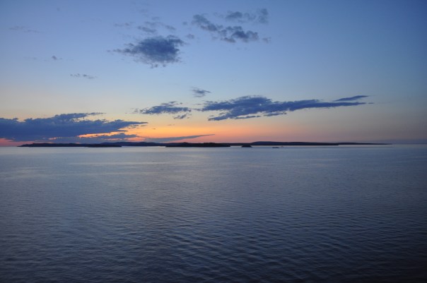
The Sun Rises Over Isle Royale
It was the middle of May 2018 when I first landed on Isle Royale. That storied island—that mass of rock isolated in northern Lake Superior. So far away it seems logically like it should be part of Canada, yet it belonged to Michigan—the only National Park in my home state. The mystery of that island beckoned me from maps with its geography and isolation. Long had I wanted to discover what this coveted gem had in store.
At long last, I finally visited the island after spending a winter and a spring teaching environmental education in northern Minnesota. By that time, I had become quite familiar with the boreal northwoods from all those hours teaching kids in the wilds. The northern forests, hence, were not all that different from my everyday existence.
Given my years of anticipation, Isle Royale was bound to be something exceptionally different than what one could experience on the mainland, I believed.
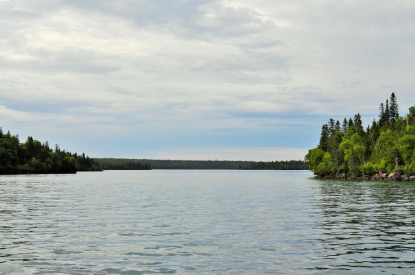
As it was, my first trip to the island was a simple, short overnight stay, ferrying in from Grand Portage, Minnesota to the Windigo Visitors Center on the western end of the island. As far as landscapes go, the flat, forested, mixed-conifer forests of Windigo are not spectacularly different than the Minnesota Northwoods I had become accustomed to.
I was a bit underwhelmed.
I didn’t even bother to take any pictures (incidentally, my camera had broken earlier that trip).
Arriving at Washington Harbor at Windigo
I left Isle Royale that trip convinced that I had seen the island in the wrong way. A simple overnight trip was no way to do the island ecosystem justice. If I was ever to return to Isle Royale, I thought, I would do it in the right way: I would hike the island from end to end, slow enough to absorb the ecological transitions, to understand the essence of what makes the place, and to enjoy immersion in the vast isolation of Isle Royale.
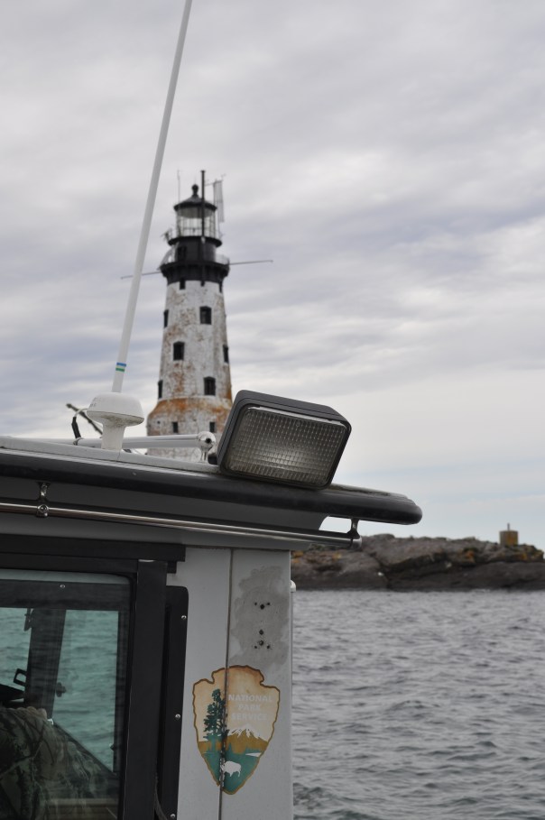
As chance would have it, in the summer of 2019 I was selected to take part in a volunteer restoration crew on Isle Royale’s Rock of Ages Lighthouse. I would be returning to Isle Royale sooner than I had thought, and this time, I would be staying on to hike across the island afterwards.

The Rock of Ages Lighthouse
I started my hike on the western end of the Island, at Windigo, the widest part of the island. Here the forest commands the land and the coastline is smoother, less jagged. I made my way to the Greenstone Ridge trail, the hiking path that transects the middle of the island. Despite its name, the Greenstone Ridge at this point isn’t much of a ridge at all. The trail slowly climbs uphill under the cover of a mixed-forest—conifers, but also maples and even the warm-and-dry loving oaks. I spent my first night at the interior campsite of Island Mine, the site of an 1870’s copper mine that peaked and was abandoned in only a few years.

Broadleaf forests found more commonly on the western end of the island
Mining history would be a big theme of the hike, and copper was the resource of value. It wasn’t just white Euro-Americans who were mining the island either: the Ojibwe, the indigenous people of Isle Royale, had mined the island for thousands of years. Archeological evidence suggests that as early as 4500 years ago, indigenous people harvested copper by using stones to hammer off chunks of native copper from outcroppings in the bedrock. As their technology progressed, they began to mine deeper in the bedrock by building large fires over ore deposits, then quickly dousing the fire with water in order to crack the bedrock. Small indigenous mining pits can still be seen throughout Isle Royale today. By the 1840’s the Objibwe had been duped into ceding their lands to settlement and development for the resource-hungry Americans. Speculators flocked to the island to make their riches, but mining on Isle Royale was always boom or bust. Island Mine organized in 1874 and extracted over 200,000 pounds of refined copper. Three years later, the company went bust. All that remains now are scattered pieces of rusting equipment and mounds of tailings.


Day two saw me continue east along the Greenstone Ridge. After a few miles of hiking through the shady canopy, I began to get my first views from the ridge: small, rocky clearings at first with scrubby oaks and small shrubs partly obscuring the views. First the clearings were few and far between, but then they became more abundant. From the ridge one could begin to see some of the inland lakes that dot the island, including the scenic Lake Desor, near the summit of Mount Desor, which at 1,394 feet is the highest point on the island. From clearings further along I could even see Ryan Island in Siskiwit Lake, the largest island in the largest lake on the largest island in the largest lake.


With the gradual opening from shady forest to open ridge, another fun thing happened: berries. Up on the ridge, the sun beats down and the soil becomes dry. The seasons progress quicker than by the lakeshore where Lake Superior tempers the weather. Whereas the thimbleberries at lower elevations were still hard and green, up on the ridge I began to encounter a progression of ripeness: first, an isolated red berry, then a few on a bramble, and finally whole thickets of the bright red berries. Thimbleberries are a thornless, velvety cousin of the raspberry, with shallow bright red berries which are so soft and juicy that they can only survive the journey from the hand to the mouth.
After gorging myself on snacks of thimbleberries and taking a mid-afternoon swim in the cool and clear Lake Desor, I made my campsite at Hatchet Lake.
The clear summer weather finally took a turn for the wet on my second night. It was a constant heavy rain that slowly drenched me. I awoke (did I even sleep?) with about an inch of standing water in my tent. I later learned that at Windigo they recorded nearly two inches of rain in that overnight.
I would start my third day soggy. Today I would be leaving the Greenstone Ridge trail for the north shore of Isle Royale and the infamous Minong Ridge. I reached Lake Superior at Todd Harbor, a picturesque cove with a mélange of water-smoothed rocks. I took a short side hike to the former open pit of the Haystack Mine, and then followed a trail just a little bit further to find a small waterfall that was the cause of some bubbling noise off in the distance. From Todd Harbor I took the Minong Trail towards McCargoe Cove. The Minong Trail, though it never reaches as high elevations as the Greenstone Ridge, deserves its reputation as a knee-destroyer. The Minong Ridge is a series of exposed escarpement ridges: a rocky, uneven gradual climb up the bare basalt, followed by a steep dropoff on the backside. Then repeat, again and again. On a hot day, it wears you out, as it wears out your knees.


I reached the deep and slender McCargoe Cove by mid-afternoon, and after such a soggy night, I was eager to rest and dry out. This afternoon, I finally got a shelter at one of the island’s campsites. They are spacious lean-tos, screened-in, and with the perfect combination of both scenic views and isolation. I dried my clothes off and basked in the sun.


Though McCargoe Cove was my favorite campsite of the hike, there were not many people there at all. Isle Royale consistently is the least visited national park in the contiguous 48 states. In 2017, this National Park had only more visitors than Lake Clark, Kobuk Valley, and Gates of the Arctic National Parks, all sites in remote interior Alaska. With only 28,196 people even paying a visit in all of 2017, more people visit parks like Yellowstone in a single day than all of Isle Royale in an entire year. The great benefit of Isle Royale’s lack of popularity is its solitude. The trails and campgrounds never feel crowded. With fewer folks around, you also develop good connections with your fellow travelers quite readily. At McCargoe Cove, I spent the evening around the campfire chatting with our only neighbors: a group of fishermen from Chicago and a pair of ladies from the Twin Cities. Trail community seems to come easily here.

McCargoe Cove: Some Hike, Others Canoe
McCargoe Cove was also the harbor used for the Minong Mine, the most prolific mine in Isle Royale’s history. Like other island mine sites, indigenous people had harvested surface copper deposits here first. In 1872, modern mining operations had commenced at Minong. This mine produced some incredible finds, such as a 5,720 pound nugget of almost pure copper. Finds like this nugget, and several other massive nuggets, added fuel to the mining fire. Two shafts were dug, up to 300 feet deep, as well as several drift tunnels that followed the ore veins. As tunnels were dug, tailings, or waste rock, began to fill in the adjoining marsh that leads to McCargoe Cove. A boomtown known as Cove sprang up at Minong, housing upwards of 150 people at its peak. Along with its railroad, stamp mill, and blacksmith shop, Cove even boasted a post office. Indeed, the prospect of permanent settlement on Isle Royale seemed so promising that Isle Royale even became its own county in 1875. By 1885, however, all mining operations on Isle Royale came to a halt for good. The grade of the ore dwindled and the price of copper fell; Isle Royale proved to be too isolated and the winters too harsh. Eventually, even though over 4 million pounds of refined copper were removed from the island, all mining ventures proved too non-economical to continue. Island boomtowns were abandoned. By 1897, with no permanent population left, Isle Royale County was re-absorbed into Keweenaw County.


On my fourth day, after very much enjoying my single-night stay in the shelter, I was off to hiking again. This time I decided to traverse the island from north shore to south shore, hiking astride several interior lakes along the way. I had been told that these interior lakes were hotbeds for moose activity. As storied and prolific as the moose population on Isle Royale has been, I had yet to see my first moose on the island. I knew they’d be around, as I had already seen plenty of moose scat and browse sign.
The scenic and shapely-named Chickenbone Lake proved of no avail for moose, though it was a Mecca for giant dragonflies. The next lake over, at Lake Ritchie, I got my first far-off glimpse of a moose browsing in the aquatic vegetation far across the lake. With the gradual decline of the predatory wolf population, the numbers of moose on Isle Royale have skyrocketed in recent years, with an estimated 2,000 moose inhabiting just over 200 square miles of island (learn more about Isle Royale Wolf-Moose dynamics here). I would only end up seeing one other moose on my trip. After losing the hiking trail on some bedrock, I wound up following a moose trail into the woods. The moose trail petered away until I reached a swamp. Suddenly, a large startled moose crashed away from me through the brush!
Though I had seen two moose, as far as their illustrious predator the wolves went, I had yet to see any. When I had visited previously in 2018, there was just a pair of wolves left on the island, simultaneously a brother-sister pair and a father-daughter pair (you do the math on that inbreeding!). In the winter of 2018-2019, four more wolves were introduced to reinvigorate the existing wolf population. For anyone, seeing a wolf is a rare treat. Alas, I never had a wolf encounter on the island; the closest I got to seeing the wolves was the island cabin of well-known wolf-moose researcher Rolf Peterson.

Moose researcher Dr. Rolf Peterson’s Rock Harbor cabin
Once at the south side of the island, I camped at the large harbor of Moskey Basin. Completely different from the small, sparsely-filled campgrounds I had been staying at, Moskey Basin was filled to capacity with both families and large groups, and its vast expanses of exposed bedrock and its picnic tables made this site feel luxurious and tame. But I should have expected that, visiting in high season after all. Even in high season, though, Isle Royale is not that busy, and getting all of that wilderness ambiance while hiking was a treat not to be taken for granted.
The cove at Moskey Basin was a sight to behold—layers of exposed bedrock outcroppings running right into the water. I hadn’t noticed it too much before, but the island was becoming rockier and rockier the further I traveled east. The exposed rocks left plenty of good places for sunbathing and also proved to be a prime habitat for blueberries (thimbleberries, unfortunately, had all but disappeared after leaving the Greenstone Ridge). Also without my noticing, the broadleaf tree canopy had disappeared too. Thin soils could no longer support the large broadleaf trees seen more westerly on the island. Instead, the forest was becoming more a stunted array of firs and spruces.


With a clear night ahead looking promising, I made a commitment to staying up to see the stars. This being mid-summer in the westernmost Eastern Time Zone, the sun did not set until near 10pm, and the stars did not emerge until well afterwards. After a full day of hiking, I was usually in my tent well before the stars came out in their full glory. But I stayed up tonight and was treated to a show on an absolutely moonless night. Being miles away from any human settlements, the stars on Isle Royale are absolutely amazing!


My last day on Isle Royale would take me into the primary tourist outpost at Rock Harbor. Rather than hugging the shoreline trail to my final destination, I once again went inland to take the Greenstone Ridge home. The trail up to the Mount Ojibway Fire Tower was never too steep, provided uninterrupted views, and proved to be premiere blueberry habitat. The whole climb up I had a constant handful of blueberries as a power snack. The Mount Ojibway Fire Tower, unlike its much squatter kin at Mount Ishpeming, actually provides visitor access to the base. Climbing the tower provides views of the entire island from north to south.


The Greenstone Ridge continued its path northeast across exposed rocky and grassy balds. By the time I reached the Mount Franklin lookout, it was clear I was encountering a different area. The overlook was populated with day-tourists hiking up from their various Rock Harbor lodgings. I left the viewpoint and went on the downhill to Rock Harbor and my hike’s end. At the eastern end of the island, Isle Royale’s tilted geology splits the island into many narrow peninsulas and long bays running towards the northeast. I walked along these deep harbors right along the trails by the edge of Superior’s turquoise waters.
A sign for campsites signaled that I had made it into Rock Harbor. I could now bask in the luxuries of this tourist depot. Modern settlement at Rock Harbor started with a few unsuccessful mining ventures in the 1840’s, then moved into the realm of commercial fishing, as Scandinavian immigrants built their fishing shanties after the copper booms. By the early 1900’s, these fishermen were guiding pleasure-seekers around the island and accommodating throngs of tourists in cabins. Several resorts eventually popped up, having their heyday in the 1920’s. The Great Depression and changing societal tastes caused a drastic decline to tourism in the 1930’s. By 1940, Isle Royale had been declared a National Park, and the National Park Service began the process of buying out and shutting down the remaining tourist resorts and removing fishermen from the island. Gradually, this formerly logged, mined, and settled island would be transformed into a 99% wilderness park with no permanent population.
Today Rock Harbor boasts a store where one can buy fresh vegetables as well as craft beer, hot showers ($6 for a five-minute shower), laundry, a restaurant, rustic cabins, and even a few hotel rooms. For this wilderness traveler, it was a world apart from the Isle Royale I had just experienced. The development at Rock Harbor was a foil to the isolation of the island. Though I milled about the Rock Harbor Village for a while, it just wasn’t what I needed. I made off to a quiet edge of Lake Superior and took a long, cleansing swim in her waters. For me, that is what Isle Royale is about.
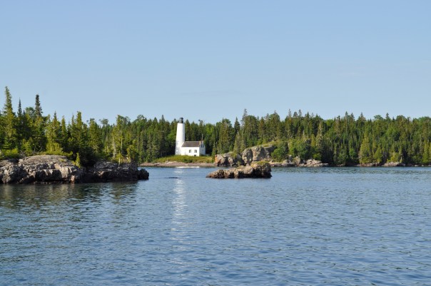
Rock Harbor Lighthouse

A Week on the Rock: Restoration Volunteer at the Rock of Ages Lighthouse

Vintage image of the Rock of Ages Lighthouse (image from Rock of Ages Lighthouse Preservation Society)
Northwestern Lake Superior, May 27, 1933, 6pm—The passenger steamer George M. Cox plies briskly through the frigid waters at full steam ahead, despite a heavy fog having settled over Lake Superior. On her maiden voyage after an elegant and expensive refit financed by New Orleans businessman George Cox, the Cox is bound for Port Arthur, Ontario carrying a load of 127 prominent guests, passengers, and crew. The captain and owner of the Cox need her to make good time on this voyage in order to impress her passengers and to show the Cox’s viability against other steamer lines in the lucrative vacation travel business. In the heavy fog enveloping the lake, Captain Johnson and First Mate Kronk can hear the fog signal from the Rock of Ages Lighthouse—they know they are near Isle Royale, but continue onward at 17 knots. Suddenly—a jarring jolt and the sound of scrapping metal. The George M. Cox runs full speed into the Rock of Ages Shoal, lifting 110 feet of her bow out of the water and giving her a dangerous list to port. The command to abandon ship is immediate.
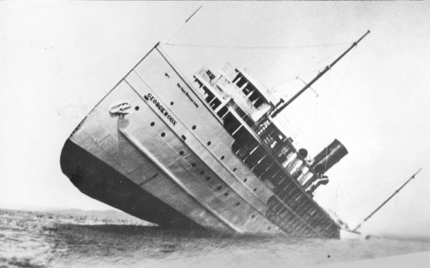
The wreck of the George M. Cox (image from Ampers)
On watch from the Rock of Ages Lighthouse, head keeper John Soldenski hears the crash and lowers the rescue boat to race off to the scene of the wreck. Though the wreck of the Cox was spectacular, there were no major injuries and Soldenski is able to tow all the life rafts safely to the lighthouse. At this cylindrical lighthouse on an isolated rock outcropping no bigger than 50 by 200 feet, all 127 passengers and crew onboard the Cox would spend a bitter and cramped night. The rescued crammed into the spiral stairwells of the Rock of Ages, or alternatively took turns huddled against the cold on the rock itself to avoid the overcrowding. The next day, rescue ships removed all George M. Cox passengers and crew with minimal injuries sustained and no loss of life in the wreck and subsequent rescue. As for the Cox herself, insurance declared her a total loss and she sat beached on the reef for months. She became a tourist attraction in her own right, and local Isle Royale fishermen brave enough to enter found many luxury goods to plunder. October storms later that year broke the Cox in two, and she slipped quietly to the depths of Lake Superior.
Despite this history of heroism and lore of rescue on the high seas, technological advancements and automation eventually led to the end of the keeper era at Rock of Ages. In 1978, the light was automated and the final keepers said their goodbyes. The lighthouse itself was prepped for its abandonment—windows were filled in with cinder blocks, doors and fixtures were removed, and all the interiors were coated with semi-gloss white paint—even the remaining light bulbs. In 1985, Rock of Ages’ magnificent 2nd order Fresnel lens—a lens that allowed a flame to shine for 29 miles—was removed and replaced with a much smaller solar-powered lantern. The door to the lighthouse was locked. The magnificent beacon that is the Rock of Ages was left to weather the elements alone.
But such an iconic and storied lighthouse could not be left alone to weather away indefinitely. A group of citizens, concerned with the fate of the Rock of Ages Lighthouse, formed the Rock of Ages Lighthouse Preservation society with the mission of restoring the lighthouse to its 1930’s appearance and to opening up the light to public visitation. Restoration work has been undertaken on the light since 2014. In July of 2019, I was able to join in these restoration efforts for a week of volunteer service at the Rock of Ages itself.
Getting dropped off for the week
The crew was led by two-time lighthouse volunteers, the Nebraska couple Josh and Heather: odd-job experts, and woodcraft miracle workers. Joining them were me and Dakota Dirk, a professional historical restoration carpenter from Minnesota and an avid collector of antique oddities. For five nights, we stayed at the Rock of Ages itself. Our project goal for the week was to finish installing the 3rd floor hardwood flooring and to install window, door, and baseboard trim on the 3rd floor galley and the 4th floor keepers’ quarters. I would be staying in the unfinished 5th floor assistant keepers’ quarters.


The Rock of Ages Lighthouse is located more than 20 miles off the North Shore of Minnesota, and another five miles southwest of the Windigo Visitors Center on Isle Royale National Park. Upon arriving at Windigo on our first day in service, we immediately took a smaller, former NPS patrol craft to the shoal on which the Rock of Ages sits. Seeing as how Lake Superior is rough and unpredictable, and how the lake has claimed many larger ships throughout the years, the length of our stay would be determined by when the weather was favorable to access the light. It is a situation still the same as the keepers of old; during the active years, the keepers’ tours of duty would be subject to the mercy of Lake Superior. Keepers could often be stranded for days or weeks until weather would allow a ship to remove them at the end of the season. One crew of keepers was down to a single can of tomatoes for provisions when they were finally removed from the lighthouse. Hopefully our restoration crew would not suffer the same fate; we packed plenty of extra peanut butter just in case.
At the dock on the Rock of Ages
Our first day on the Rock of Ages was spent exploring the place that would serve as our home base for the next five days. The rocky reef on which the Rock of Ages sits is a jagged piece of basalt that emerges from nowhere and drops precipitously off into the azure waters of Lake Superior. No wonder this place posed such an immanent threat to shipping traffic. The Rock of Ages Light was built to mitigate the hazards of this reef. Construction began in 1908, when workers blasted a 50-foot diameter hole in the rock down to water level, in which the foundation of the lighthouse would be laid. The first two levels of the lighthouse, encased in steel and concrete, were finished in 1908 and served as storage areas for the Light. Being at water level, these two levels were constantly battered by waves and exhibit a characteristic clammy dampness. The remaining eight levels of the Light were completed in 1909. The main floor of the lighthouse was the third level up, and contained the engine room. From there, the spiral staircase leads past the 2nd floor lounge and office, 3rd floor galley and mess hall, 4th and 5th floor keepers’ quarters, 6th floor watchroom, 7th floor service room, and finally the 8th floor lens room. A journey up the lighthouse’s 149 steps will take one past various unrestored levels with peeling paint and blocked-off windows, as well as a few freshly finished and yellow-hued rooms. From the panoramic views of the lens room, 117 feet up, one can look out on Lake Superior and see the buoys that mark the wreck of the ill-fated Cox, along with the 1877 wreck of the Cumberland and the 1898 wreck of the Henry Chisholm.


Our volunteer work focused on installing flooring and trim work in the 3rd and 4th floors. Restoration crews in prior weeks and years had previously demoed and painted these levels in order to make them habitable for work crews staying out at the lighthouse. Our job was to wrap things up by installing the finish trim. This was no simple task, as all our trim pieces were straight, and the entirety of the lighthouse is circular (not to mention that water damage and exposure had rotted out much of the underlying structural wood we were nailing into). Using a variety of construction techniques, some woodbending, lots of trial and error, and perhaps some voodoo magic, we as a crew were able to finish most of the trimwork on these floors. Adding the trimwork really tied the rooms together. And being period appropriate too, all the trimwork was a fancy compilation of early 1900’s-style solid oak. Despite being such an isolated lighthouse, the keepers at Rock of Ages were blessed with quite ornate woodwork.


Even though the restoration crew put in long hours on the restoration project, there was still plenty of time to enjoy spending at the lighthouse itself. With so much restoration work actively going on, the lighthouse was a great place to play architecture sleuth. One of my favorite down-time activities was roaming the floors of the lighthouse trying to piece together its history—its construction, its changes, and its restoration. Hanging out in the lens room was the best location to feel the immensity of Rock of Ages’ isolation. To the east is a view of the entirety of Isle Royale; to the north is Minnesota’s North Shore and the Sleeping Giant of Ontario; to the south the endless expanse of Lake Superior. My favorite spots to watch the sunset were in the lens room and on the 7th floor catwalk. With favorable weather most of the week, we were always treated to spectacular sunsets and to watching seagulls fly in the wind.


Blow Ye Winds!
Despite the lighthouse’s isolation, we had several visitors stop by throughout the week. Maintenance workers from NOAA stopped by to maintain weather equipment, and the National Park Service had groups of protection and maintenance rangers stop by. Our daily break was also timed around 2:20, when the Sea Hunter III would pass by with day-trippers to Isle Royale who all took pictures and waved.


")
Our friends also included the many seagulls who called the Rock of Ages home. Their calls intermingled with the wind to provide the constant background music of Rock of Ages. In high winds, from the lens room, we would watch as the seagulls had a heyday soaring in the breeze. There were also several fledgling seagulls born on the Rock that we watched in anticipation, waiting for their first flights down to the water.


Our other constant friends were the midge flies. Every object outside the lighthouse was coated thickly with a layer of midge flies and other insects taking shelter from the constant wind. On the few occasions that the Lake Superior winds ceased to blow, the midges would take flight, forming an airborne swarm. I, as well as everyone else, inhaled too many midges to count.


At last, it came time to leave the Rock of Ages. The final two days of our volunteer period had thunderstorms in the forecast; we would need to leave the reef while we had a good weather window. Though I find it disappointing that we never experienced the extreme weather that the old-time keepers had experienced (with waves crashing up to at least the 6th floor ), it was a spectacular week on the Rock nonetheless.


")
