Blog Archives

State of Mind, State of Being
space
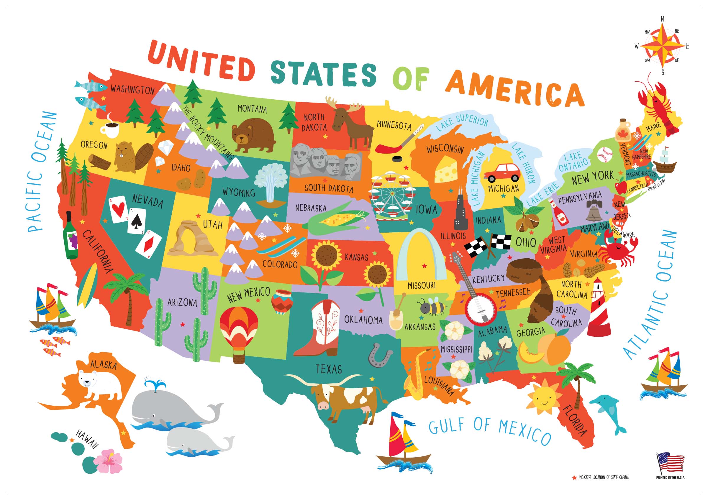
The United States of America, with its fifty nifty geographical sub-units, neatly divides up this diverse nation into different states that each has a generalized culture and personality. As someone who is not yet settled down with a permanent address, I still have the flexibility and open-endedness to decide which state I want to live in for the long haul. From working jobs in a variety of locations, I have gotten a taste of many different geographies, a smörgåsbord of potential places to call home. In any given year, I seem to work in about three different states, which doesn’t usually include my birth state of Michigan. This prolonged period of ‘geographical investigation’ has given me some insights into where I might want to settle permanently based on my experiences in each state. While I have explored around the country quite a bit (see this page on my personal website for the most up-to-date map of U.S. counties I’ve been to), I’m a northerner at heart—I’ve never stayed long in a place under 40°N. And while I’ve worked jobs on both the East and West Coasts, I always return home to the Midwest.
From my adventures, I have my own thoughts about potential locations to settle, as well as to what my ‘soul state’ might be. But I thought I’d elicit some help from the omniscient ether—by taking a number of sleazy internet quizzes to see where the quiz writers think I belong. These quizzes—though far from scientific—are quite fun to play around with. I’ve listed them here according to my self-rated quality of the quiz, from best to worst:
What were my results? Out of seven quizzes taken, surprisingly none of them yielded the same state. However, there seems to be a strong connection to northern New England, as I was matched with Maine, New Hampshire, and Vermont (even though New York is not considered part of New England proper, I’ll clump it in with this category because the most desirable part of New York for me, Upstate, has a lot in common with northern New England). These four states—charming small towns, more rural populations, historic places, and winding roads through hills and deciduous forests—all seem to be a good match for what I’d be looking for in a habitat. The quiz from Quizony was the only one that picked what I consider to be my ‘soul state’ of Vermont: fiercely-independent, sustainability-minded, ample greenery, and the fewest Wal-Marts of any state.
space

space

space

space

space
And as for my natal Midwest? Sadly, no quiz matched me with my birth state of Michigan. I guess it turns out that I don’t fit in with the bulk of the state, though I think quite highly of life in the rugged frozen Upper Peninsula (Yoopers are a special breed, and I don’t think I could ever live up to their cred). I was quite happy that Wisconsin appeared as a match. I really am fond of the upper Great Lakes region, especially around Lake Superior, and I’ve been quite frequently perusing for real estate in northern Wisconsin. Cheese curds and a good football team? Count me in.
space

space
Then there were two far-flung results. Washington State, with its forests, mountains, and avid outdoor recreation culture seems to be a good fit for me. And though I enjoy visiting and recreating in the west, the West Coast has never really felt like home to me. Finally, my most out-there match was with Tennessee, provided by Buzzfeed. Apparently the quiz determined that I have an undiscovered penchant for country music that makes me belong in the South (even though when given the quiz question for musical preference, I explicitly chose rock over country).
space

space

space
Of course, no online quiz can ever compare with the process of getting to know a state in person. So get out there and start exploring to find your own perfect state!
space
space
space

Geographical Oddities
For those of you interested in some of the irregularities of state political boundaries—for instance, why Michigan is separated into two large peninsulas, why Oklahoma has a panhandle, or why Colorado is just a boring old rectangle—there is a great book to read. That book is How the States Got Their Shape by Mark Stein. In detail, Stein explores each state’s border—explaining the various social and political forces, many oft-long forgotten, that went into the making of each state’s boundary. It’s an easy and entertaining read, and it is quite surprising to learn how often petty disputes (i.e. Missouri’s southeast corner) or rudimentary surveying mistakes (i.e. the Kentucky/Tennessee border) made America’s state geography much more complicated than it ideally should have been.
For some folks, it is simple enough just to read about peculiar political boundaries. For others, it is necessary to visit them (think about the 4-corner intersection of Colorado, Utah, Arizona, and New Mexico, which is a modern-day tourist attraction. The allure of being in four states at once is well worth the three dollar entrance fee!)

The Utah, Colorado, New Mexico, Arizona 4-corner border. Yes, I’ve been there.
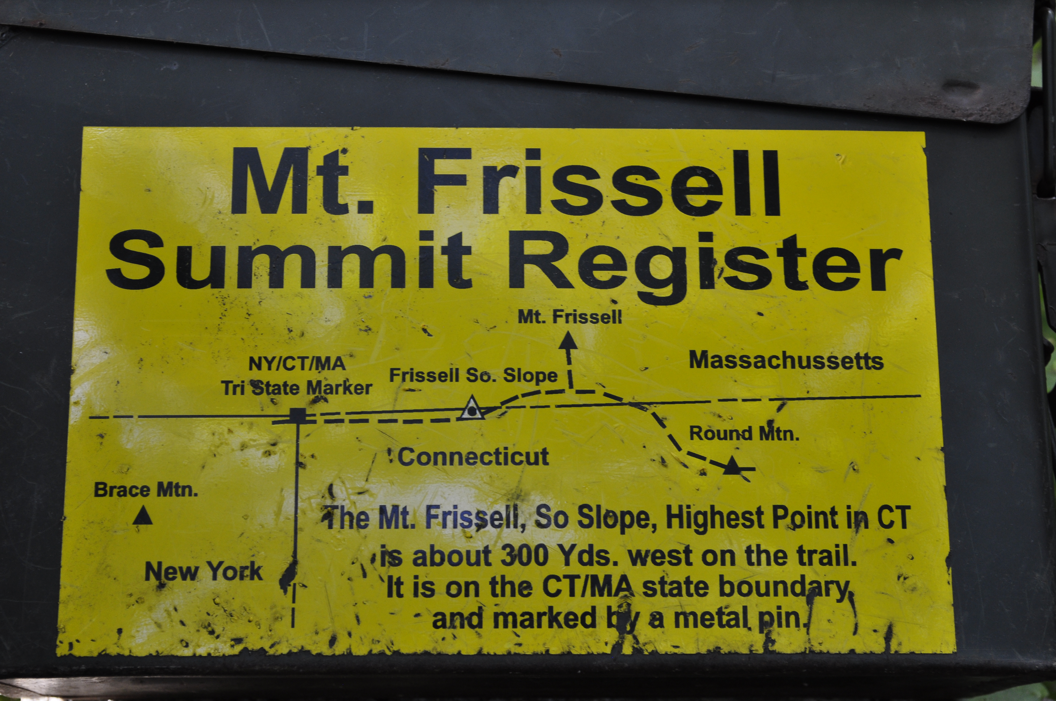
And, as American political boundaries rarely follow logical physical geographical boundaries, the result is some absurdities in state physical geography extremes. Recently, I spent a weekend exploring some geographical oddities near me; in particular I went to Mount Frissell, a mountain in Massachusetts which oddly enough is also the highest point in Connecticut.
What drew me to this particular non-descript mountain in the extreme southwestern corner of Massachusetts? Well, it was a form of geographical tourism known as highpointing. Simply put, highpointers are people who try to reach the highest point in each state or region. Now personally, I had previously climbed the tallest mountain in a few states before, but I had never really made highpointing more of a goal until I picked up a guidebook of state highpoints at a library used book sale last year. Being somewhat of a geography nerd, I thought it would be a fun travel project to undertake (at least to all the highpoints in which ropes and glacier travel are not required!)
And hence I learned about Mount Frissell. Though the mountain has its own scenic merits and was quite a lush walk through the deciduous Connecticut uplands, I would have had incredibly little reason to ever visit otherwise.

Mount Frissell
My approach to Mount Frissell came from the Connecticut side of the mountain, where an inconspicuous town road out of Salisbury eventually leads to the trailhead destination. I drove northwards out of town, up a narrow dirt road lined with verdant shrubs and trees. Immediately after hitting the state border marker with Massachusetts, I was at the trailhead. Oddly enough, I would not enter Connecticut on this trip again until I emerged at its state highpoint!
The trail to the summit begins deceptively flat and effortless. A quarter mile in, though, as East Coast trails are prone to do, the path shoots straight up the bedrock slopes of Mount Frissell. Fortunately, the trail was short enough, the views rewarding, and in less than an hour I was at the summit of Mount Frissell, elevation 2,454 feet.
Though I was at the summit, I still had not accomplished my highpoint goal for the day (nor was I at the highpoint of Massachusetts. That honor belongs to Mount Greylock at 3,489 feet, just a couple hours’ drive north.) Fortunately, my climbing portion was done. All I needed to do now was to descend about 300 yards down Frissell’s south slope until I reached the Connecticut border.
A rock cairn and a humble state survey marker are the only evidence that you’ve made it to Connecticut’s highpoint, a modest 2,379 feet. The area itself looks little different from the surrounding forest, and, being on a slope, the views are fairly obscured by vegetation. Nevertheless, I enjoyed being the highest person in the state of Connecticut for awhile, as I rested and perused the trail register notes left by fellow highpointers.
For geography bonus points, continue walking west on the trail for a few more minutes. Soon you will come upon the tri-state boundary for Massachusetts, Connecticut, and New York. As you stand there deep in the woods, maybe you’ll wonder to yourself ‘why in the world did people bother to put this giant stone obelisk in the middle of the forest?’ Well, that’s geographers for you.

The New York, Connecticut, and Massachusetts Tri-State Boundary
Other nearby state superlatives of note: Bash Bish Falls, measuring nearly 200 feet in a series of separate cascades, is Massachusetts’s highest waterfall. Well worth the visit.

Bash Bish Falls, Massachusetts’s Highest Waterfall

Counting by Counties
An item on many people’s bucket lists, including mine, is to visit every one of the fifty United States. It’s a large task, considering the vast size of our country…but then again, it’s not too challenging when one considers how large most states are and how merely transiting around this country will often result in unintended visits to new states and to new places. As for me, before I reached the age of 27 in 2017, I had already set foot in 48 states and the District of Columbia. Mapped out, it looks like I have visited most of our country:

But for how many people, is visiting every single county in the United States on the bucket list? Instead of a mere 50 states, the total list extends to 3,142 counties*. For fellow alumnus of Calvin College’s Geography Department Tom Byker, this was a very intentional goal. Byker started his earnest quest to visit every single American county after beginning college, and this county-visit project was one highlight on his resume that helped him in landing a job at the navigational company TomTom. Tom recently brought his county visit project to a close after visiting his final county in Hawaii in 2017.
Inspired by the fine-scale travel goals of Tom Byker and the other ‘County Collectors,’ I decided to make my own map of county visits, mainly out of curiosity of where I’ve been in each state. I have never kept a formal list of counties that I have visited, so the entire map is based off memory of past travels I have been on. The majority of county travel has occurred during college and beyond, but I did try and reconstruct the county locations of some early family trips. And yes, I did count driving through a county as adequate for a visit. Here is what my county-scale map looks like:

And what can I learn from the county-level map?
- In total, I have visited 924 of 3,142 counties, which is about 29% of all counties.
- Despite visiting 48 of 50 states, there are still large swaths of the United States that I have not visited, namely the South and the Southeast.
- It becomes quickly apparent in which counties the interstates are. Interstates 94, 90, 80, 70, 44, 40, 35, 55, 57, 65, 69, and 75 all readily pop out, as well as U.S. Highway 2. Can I say, ‘Road Trip?’
- It’s easy to tick off county visits in the Western U.S. Not only is the West a great road trip destination, but the counties are also much larger. For example, Wyoming’s counties average 4,257 square miles while Georgia’s counties average only 373 square miles.
- I have visited every single county in two states: Oregon (completed in 2014 after a 2012 summer internship and lots of Grad School fieldwork in the state) and Massachusetts (completed in 2017, which included visits by ferry to both Martha’s Vineyard and Nantucket Islands, which are their own respective counties).
- Broken down by counties, the states I have seen the least of are Louisiana (<5%), Arkansas (<3%), and Texas (<2%) (excluding North and South Carolina, which I have not yet visited).
- I have visited less of my own home state of Michigan than many other states. I have visited 71% of all Michigan counties, which ranks my home state as only 12th on my list according to percentage of counties visited.
*Here I use the term county broadly to include all U.S. counties or county equivalents. Most states are divided into counties, but Louisiana is similarly divided into parishes, and Alaska is similarly divided into boroughs. Additionally, several states (although primarily Virginia) have cities that are independent of any county. All of these categories are combined to get the number 3,142.
Maps generated are courtesy of mapchart.net
Here is the state-wide data on visits to each state:
| State | # Counties | # Visited | % Visited |
| Alabama | 67 | 16 | 23.88% |
| Alaska | 29 | 3 | 10.34% |
| Arizona | 15 | 5 | 33.33% |
| Arkansas | 75 | 2 | 2.67% |
| California | 58 | 52 | 89.66% |
| Colorado | 64 | 26 | 40.63% |
| Connecticut | 8 | 7 | 87.50% |
| District of Columbia | 1 | 1 | 100.00% |
| Delaware | 3 | 1 | 33.33% |
| Florida | 67 | 10 | 14.93% |
| Georgia | 159 | 24 | 15.09% |
| Hawaii | 5 | 2 | 40.00% |
| Idaho | 44 | 40 | 90.91% |
| Illinois | 102 | 44 | 43.14% |
| Indiana | 92 | 36 | 39.13% |
| Iowa | 99 | 21 | 21.21% |
| Kansas | 105 | 18 | 17.14% |
| Kentucky | 120 | 9 | 7.50% |
| Louisiana | 64 | 3 | 4.69% |
| Maine | 16 | 13 | 81.25% |
| Maryland | 24 | 8 | 33.33% |
| Massachusetts | 14 | 14 | 100.00% |
| Michigan | 83 | 59 | 71.08% |
| Minnesota | 87 | 32 | 36.78% |
| Mississippi | 82 | 25 | 30.49% |
| Missouri | 115 | 22 | 19.13% |
| Montana | 56 | 34 | 60.71% |
| Nebraska | 93 | 19 | 20.43% |
| Nevada | 17 | 9 | 52.94% |
| New Hampshire | 10 | 7 | 70.00% |
| New Jersey | 21 | 15 | 71.43% |
| New Mexico | 33 | 7 | 21.21% |
| New York | 62 | 25 | 40.32% |
| North Carolina | 100 | 0 | 0.00% |
| North Dakota | 53 | 20 | 37.74% |
| Ohio | 88 | 26 | 29.55% |
| Oklahoma | 77 | 13 | 16.88% |
| Oregon | 36 | 36 | 100.00% |
| Pennsylvania | 67 | 40 | 59.70% |
| Rhode Island | 5 | 4 | 80.00% |
| South Carolina | 46 | 0 | 0.00% |
| South Dakota | 66 | 18 | 27.27% |
| Tennessee | 95 | 12 | 12.63% |
| Texas | 254 | 5 | 1.97% |
| Utah | 29 | 13 | 44.83% |
| Vermont | 14 | 7 | 50.00% |
| Virginia | 133 | 14 | 10.53% |
| Washington | 39 | 34 | 87.18% |
| West Virginia | 55 | 6 | 10.91% |
| Wisconsin | 72 | 49 | 68.06% |
| Wyoming | 23 | 18 | 78.26% |
| Total | 3142 | 924 | 29.41% |
