
The Socially Distanced Cyclist: 16 Days, 1,170 Miles, and Minimal Human Contact Around the Coast of Lower Peninsula Michigan
From August 9 to 24, 2020, I took a solo, self-supported bicycle trip to explore the coastline of my home state, the great state of Michigan. Being the Great Lakes State and a water wonderland, Michigan offers 3,224 miles of freshwater coastline to explore as well as 124 lighthouses, both of which are the most of any state. The following is a summary the trip, encompassing 16 days, 1,170 miles, and following the coastline of Lake Michigan and Lake Huron around Michigan’s Lower Peninsula.
Approximate Route:

Day 1: Familiar Territory
Zeeland to Muskegon State Park: 67 Miles


It was a beautiful summer Sunday afternoon when I finally departed for my trip after a much longer than anticipated morning of final preparations. Bluebird skies and temps in the 80’s made it a day more fitting for a beach holiday than a long, sweaty bike ride. I would start the trip covering very familiar territory, a survey of the Lake Michigan beaches within just a short driving distance of where I grew up. I hopped on my overloaded bicycle and listened to the new squeaks and groans as the immense weight found its equilibrium on my old Cannondale, crossing my fingers that no spokes would snap (wanting to keep myself socially-distanced as possible, I chose to pack around 35 pounds of food so I wouldn’t need to re-provision the entire trip). My first leg would be the twelve mile distance to the white sand beaches of Holland State Park, with a ceremonial stop to see my beloved ‘Big Red’ Lighthouse, which would mark the first of many lighthouses I would stop to see on the trip.
The Holland area boasts many wonderful non-motorized recreational paths, and I followed one of them along Lakeshore Drive, past many lakeshore mansions, nearly all the way to Grand Haven. Grand Haven State Park, another beautiful white sandy beach, was packed with beach revelers on such a gorgeous day. From Grand Haven, I crossed the drawbridge over the Grand River and proceeded northward to Muskegon. This first day of the trip was marked by getting through some of the bigger metropolitan areas on the lakeshore to the less developed lands of the northern counties. North of Muskegon lies Muskegon State Park, a much quieter and forested lakeshore dune park than both of the state parks I had visited earlier. It was at Muskegon State Park where I would first camp for the night, and, as an omen for a good trip to come, I found a $20 bill on the road leading to the park.
Day 2: Storm’s A-Brewing
Muskegon State Park to Ludington: 72 Miles


Day two started fairly leisurely on the sandy beaches of Muskegon State Park, followed by a stimulating up-and down ride through the tree-covered dunes to the Blockhouse, the highest point in the park which offers great views of the dune ecosystem. Continuing northward, I followed the aptly-named Scenic Drive paralleling the lakeshore until I reached White Lake and the twin villages of Whitehall and Montague. As recommended, I found the Hart-Montague Trail, which was Michigan’s first Linear State Park and one of the earliest instances of Rail-to-Trail conversions in Michigan (1991). The Hart-Montague Trail runs for 22 miles and connects several small country towns that offer ice creameries and small cafes. Being a former railway, the trail is undeniably flat and straight, with mostly shrubs and brush for scenery. A few miles shy of Hart, I got the itch to return to the lakeshore for more expansive scenery and some hills for interest. I turned west towards the lake and the sand-buggy enclave of Silver Lake. Though I yearned to make the short detour to the remarkable Little Sable Point Lighthouse in Silver Lake, dark ominous clouds had begun building to the west.
I followed roads along the lakeshore through the city of Pentwater and past the cottages of Bass Lake. A few miles south of Ludington, the road passes right by the Ludington Pumped Storage Plant, once the largest pumped storage plant in the world! During the night, when there is excess electricity generated, the plant will pump water from Lake Michigan up into a 1.3 square mile reservoir over 350 feet above the lake. Releasing this water during the day generates supplemental electricity during peak demand. I stopped to gawk at its massive industrial workings, until a security guard came and asked me to leave. The guard said they were shutting down the overlook due to impending weather and showed me the radar on her phone. Yikes! I made a mad bike dash down from the high dunes to the city of Ludington, where I fortunately was able to set up camp before the heaviest rains set it. It was an eventful night as lightning flashed and thunder cracked overhead, but this would prove to be the only rain encountered on the whole trip.
Day 3: This is Hilly Amazing!
Ludington to Sleeping Bear Dunes National Lakeshore: 78 Miles


The storms had passed during the night leaving me with wet gear, but a warm sunny day proved to be in order once again. North of Ludington, Hamlin Lake and Nordhouse Dunes (Lower Michigan’s only federally-designated wilderness area) block road access to the lakeshore, so I took an inland route of country roads through the matrix of forest and small farms. Riding into Manistee took me back to the lakeshore, and proved to be stop with plenty of great parks to relax at along the lakefront. A few miles north of Manistee, while riding on Lakeshore Road, I got caught up in paying too much attention to a car behind me as I looked to turn left towards the beach access. My front wheel slipped off the paved roadway immediately bogging down in the soft beach sand and causing a slow-motion flip over the handlebars. Aside from a few superficial scratches on my hands, knees, and bike, I was shaken, but OK.
I continued on, albeit more wary of soft shoulders now, around Portage Lake and the small town of Onekama. Onekama is the southern terminus of Michigan Highway 22 (or M-22), that famed route whose highway sign is emblazoned on merchandise and bumper stickers all over Michigan. Reaching M-22 proved a dramatic change in riding conditions; here, the hills began. Whereas up until now things had been remarkably flat, M-22 began a series of long, winding, gradual 1-to-2 mile climbs up a sand dune, followed by a speedy descent on the other side. I maxed my downhill speed out at 39 MPH, which on a fully-loaded bicycle is simultaneously exhilarating and terrifying. I broke up the hill climbs with stops at the little Victorian town of Arcadia’s city beach, and at the much more bustling tourist town of Frankfort. I then turned my route inland toward the town of Beulah, in search of cherry pie and wine. Riding from Frankfort along the sizable Crystal Lake proved no relief from the hills, and slower travel over the terrain caused me to miss out on the treats found in Beulah. Hungry and exhausted, I made my camp for the night just a few miles to the north in the Sleeping Bear Dunes National Lakeshore.
Day 4: I Bearly Got Anywhere Today
Sleeping Bear Dunes National Lakeshore: 37 Miles


However exhausted I was from the hill climbs the day before, I woke up very excited for the route I would cover today. I would be traveling through the Sleeping Bear Dunes National Lakeshore, perhaps the most scenic stretch of land in the Lower Peninsula (indeed, Sleeping Bear was named ‘The Most Beautiful Place in America’ by ABC’s Good Morning America in 2011). My bike, however, seemed less up for the challenge. As I had feared, all the popping and groaning coming from my crank were signs that my bearings were going bad, and my crank assembly had been growing disconcertingly looser and looser since day two. I would need to make a pit-stop to have that taken care of before I found myself stranded with no pedals to pedal.
I followed the quiet stretch of M-22 into the tourist outpost of Empire, where I met up with the Sleeping Bear Dunes Heritage Trail. This trail winds through the woods through most of the park, providing most excellent riding scenery. The trail also goes over some very steep dune sections and around some very sharp curves which makes for a sendy route to keep riders on their toes. Highly recommended is the Pierce-Stocking Scenic Drive, which winds a course of seven miles over some of the biggest dunes in the park and past some of the best vistas of Lake Michigan on top of the 400-foot tall sand dunes. Unfortunately for me, and maybe fortunately for my bike, the Pierce-Stocking drive was closed in 2020 due to road construction. However, a short distance north is the epic ‘Dune Climb’, a large active dune blowout that guests are encouraged to climb. The vantages from the top are quite spectacular, and offer sweeping vistas of Lake Michigan, the dune systems, and the valleys inland. Sleeping Bear Dunes also offers opportunities for history hounds as well. Just north of the dune climb is Glen Haven, a former fishing company town that the National Park Service now maintains as a historic village. Tucked in pockets around the park are also the barns and farmhouses of homesteaders of yore. In the course of time, most homesteads folded in the region, and the main economic driver switched to tourism.
I finally stopped to have my bike repaired in Glen Arbor, and the mandatory afternoon of downtime was well spent enjoying a swim in the crystal blue waters of Lake Michigan, as well as doing some tourist shopping in Glen Arbor itself. Not a big day distance-wise, but one of the best places just to enjoy some time in the splendid destination.
Day 5: Up and Down on Leelenau
Leland to Traverse City: 84 Miles


Back in 2012, I had taken a short bike vacation with my parents to the Leelenau Peninsula, and this area offers so much for the bicycle tourist on shorter trips as well as longer ones. The bigger towns of Leland, Northport, and Suttons Bay all offer their own vibe and tourist amenities. I started my day by following M-22 into Leland, of which any stop requires a mandatory visit to the historic and artsy Fishtown. A pleasant and lightly-trafficked ride north on M-22 took me to the quiet town of Northport. About an 8 mile ride north of Northport, past many cherry orchards, I reached the very tip of the Leelenau Peninsula which is home to a state park and the impressive Grand Traverse Lighthouse. The lighthouse was open to tours, though the tower was closed due to COVID.
On my way south on M-22 towards Suttons Bay, just past Omena, I crossed over the 45th Parallel (I had actually crossed over it earlier in the day between Leland and Northport), which, being the geography nerd that I am, necessitated a reason to celebrate. The closer I got to Suttons Bay, the more traffic M-22 picked up, and the worse shape the road became. Though riding M-22 next to Grand Traverse Bay was scenic, I was happy to beat the traffic by picking up the TART Trail (Traverse Area Recreation and Transportation Trail) going into Traverse City. Being the ‘Cherry Capital of the World,’ I biked past many cherry and fruit orchards on my way into the city.
Day 6: On a Mission
Old Mission Peninsula to Charlevoix: 78 Miles


The start of the day would take me onto the Old Mission Peninsula, the very long and narrow stretch of land that neatly divides Grand Traverse Bay in two. I peddled up the Peninsula on the west side’s Peninsula Drive, which offers a very quick and flat route to the tip, going past miles of miles of really fancy waterfront properties along the way. At the tip of the Old Mission Peninsula lies the Mission Point Lighthouse and a nice beach with crystal clear waters. The route back to Traverse City, along the main highway M-37, offered quite a contrast to the solitude and ease of Peninsula Drive. M-37 goes through the middle of the Peninsula, meaning the road goes up and down many hills as it winds its way mostly through vineyards. Though the hills were challenging, they did provide some incredible vistas of vineyards and Grand Traverse Bay. Had it not been before 10AM, I would have stopped for a tasting.
Once back into Traverse City, I caught the TART Trail to its eastern terminus in Acme, a few miles away. I was glad to avoid the heavy development and tourist traffic along that stretch of US-31. Once the path ended, I followed the signed bike route through some bucolic country acres until I ended up at US-31 again. During route planning, I had wanted to bike that stretch of US-31 as it passes on a narrow strip of land between Lake Michigan and both Elk Lake and Torch Lakes. In hindsight, this was the only section of my route that I wish I had changed. US-31 along that stretch has only a narrow, crumbling shoulder, and the summer tourist car traffic is constant. Even worse, the route has absolutely no views of any lake along the way. As a plus side, though, the heavy tourist traffic does bring with it an abundance of roadside food, fruit, and sweet stands, and Elk Rapids makes a nice town to stop at. Given that it was an exasperatingly hot and sunny day, I made my fill of stops along the way to replenish my belly and refill my electrolytes with some pasties, pastries, and apple cider.
Day 7: Through the Tunnel of Trees
Charlevoix to Cross Village: 81 Miles


Whereas the previous two days were spent biking around the Grand Traverse Bay, today I would bike around the Little Traverse Bay. First stop of the day was in the harbor town of Charlevoix, outside of which I picked up the Little Traverse Wheelway bike path. With the underlying bedrock of the region being limestone here, I made several lengthy stops along the lakeshore to try my hand at fossil hunting. Being so close to Petoskey, I was really hoping to find a stellar specimen of the city’s namesake and Michigan’s state rock (even though Petoskey stones are indeed a fossil, they are not Michigan’s state fossil). Alas, good specimens of Hexagonaria coral (AKA Petoskey stones) were difficult to find, but it doesn’t take an expert paleontologist to soon pick out many other fossils in the mix; fossilized horn corals, bivalves, brachiopods, and crinoids all make the lakeshore a Devonian paleontologist’s playground. Following the nicely-paved Wheelway around Little Traverse Bay will take you to the towns of Petoskey and Harbor Springs, both of which offer plenty of dining and shopping amenities. Petoskey offers a large historic downtown area built into a hillside, whereas Harbor Springs caters to the yacht club upper-crust.
Past Harbor Springs, following Michigan Highway 119 (M-119) is both the motorist and cyclist eye-candy route known as the ‘Tunnel of Trees’. The Tunnel of Trees is a splendid, curvy, 1 1/2 lane highway that encourages you to slow down and enjoy being immersed in the trees as the highway meanders along a sand dune bluff for nearly 20 miles. Traveling, as I was, on a mostly cloudy evening, I encountered very little auto traffic (I let my eyes wander once again, forgetting entirely my days-earlier episode of crashing my bike). At the northern end of the Tunnel of Trees is the tiny settlement of Cross Village, most notably known for its iconic roadhouse, the Legs Inn. In the 1930’s Polish immigrant Stanley Smolak, along with the help of local Odawa craftsmen, began to build the fantastical building using local stone and driftwood. It is highly recommended as a place to eat, or at least walk in and feast your eyes on the décor. Wait times often exceed one hour. Though a hot meal and a beer sounded nice after such a long day, I was burning daylight and had to get to my campsite near Wilderness State Park.
Day 8: In the Straits, not in dire straits
Wilderness State Park to Mackinac Island: 45 Miles


Wilderness State Park is a fantastic, remote expanse of land on the northwest tip of lower Michigan. It offers wide swathes of pine forest and vast expanses of sand dunes, and is highly recommended to spend a full day there. My time in Wilderness State Park would prove eventful. I had just started biking for the day when I came around a corner and saw two young men frantically waving for me. I caught glimpse of a motorcycle stuck under a truck, which is what they were making a big fuss about. I stopped to help the two guys, both named Tyler, incidentally, to get the motorcycle out from under the truck. By that time, I had already pieced together the narrative that the man with the fresh patches of road rash had lost control of his motorcycle going around the curve, and had slid under the parked truck. Fortunately everyone was OK, and I helped Tyler clean up his road rash a bit. Of the three of us there, only my flip phone had cell service, and I stayed with them until they arranged a tow. Flip phone for the win!
Since I no longer had time to explore the vastness of Wilderness State Park, I picked my way along rough rural roads in Emmet County towards the very tip of the Mitt at Mackinaw City. Along the way, however, I couldn’t resist stopping when I saw a sign for the McGulpin Point Lighthouse (which, by the way, you could actually climb the tower). From the McGulpin Point light tower, I could get a great view of the Mackinac Bridge spanning the Straits of Mackinaw. I was at the tip of the peninsula, but the Mackinac was a bridge I would not cross (at least not on this trip). Nearby the lighthouse is the Headlands International Dark Sky Park, and the region is perfect for stargazing on a clear night.
Now that I was halfway through my ride and at the tip of the Peninsula, my crowning stop would be an afternoon spent on Mackinac Island, Michigan’s iconic and premier island destination. A former British fort and a tourist destination since the mid-1800’s, Mackinac Island was once even briefly a federal National Park (1875-1895). Today, the island is known for its bikes and horse-drawn carriages, its Victorian architecture, its fudge and tourist shops, and for being carless. It is a half-hour ferry ride to the island from Mackinaw City, and to get to the ferry terminal you have to pass through all the shops of downtown Mackinaw City that are hawking fudge and T-shirts. Once you land on Mackinac Island itself, you’ll be in downtown and will walk past all the shops hawking the same fudge and T-shirts as the mainland. But when you’re on the island, it’s special, and I did the touristy thing of buying fudge, popcorn, and postcards. The island is also great for history buffs, given Fort Michilimackinac and other historic buildings to tour, but I was there for the bike riding. A right of passage on the island is to bike the 8 mile loop on M-185 that rings the island. I had biked around the island once before on a family trip when I was in fifth grade, but biking on my own as an adult was so much better. Of course I had to make a stop at some of the iconic geological formations such as Arch Rock and Skull Cave. And there was no better way to cap off the day than by getting ice cream from the shop below the Grand Hotel’s world-record 660′ long front porch.
Day 9: Lonesome Limestone Highway
Mackinaw City to Thompson’s Harbor State Park: 74 Miles


United States Highway 23 offers a dramatic contrast to the commercialism of Mackinaw City. Never before had I been to northeast Lower Michigan. It is an region of small towns separated by large distances all built on the extractive industries. From Mackinaw City to Cheboygan, the North Central State Trail follows an old railroad grade paralleling Highway 23. Though the crushed gravel of the state trail was nice, I found I preferred the feel of pavement and the glimpses of Lake Huron that riding on the road afforded me. Traffic was light and the shoulders were wide, which meant great riding conditions.
The surrounding waters of Lake Huron are extremely treacherous, and have claimed hundreds of ships and lives over the centuries. These shipwrecks are all protected within the Thunder Bay National Marine Sanctuary. Forty miles from the Straits of Mackinac is the Forty Mile Point Lighthouse. Several shipwrecks lie in shallow water just offshore, but the remains of the 1905 wreck of the J.S. Fay lie on the beach near the lighthouse. Snorkeling, SCUBA diving, kayaking, or glass bottomed boat tours are all the best ways to see the wrecks.
From Forty Mile Point, one can get on the paved Huron-Sunrise Trail, which leads to Rogers City. Though Rogers City is small, its status as the only town of 1,000 or more people for 30 miles in either direction means that it has all the amenities a person would need. Rogers City is built on mining—mining the fossil-rich limestone bedrock that dominates the region. The limestone is crushed and used as an ingredient in cement, and Lake Huron provides easy access for shipping to distant markets. Outside the city is a special overlook that peers into the massive strip mine that gives Roger’s City its lifeblood. The Calcite Quarry, at over 1,800 acres, ships out 7 to 10 million tons of limestone each year.
Leaving Rogers City early in the evening, the sun was beginning to shine lower and lower on the horizon, while the blue open skies made the late sunshine feel quite tangible. I took a detour off of US-23 at Thompson’s Harbor State Park to search for the Presque Isle Lighthouses. Without directions or a detailed map, I followed an unnamed dirt road hoping it would take me to the lighthouses. The road dead ended at the outlet where water from Grand Lake flows into Lake Huron. The low gleaming sun, the slight warmth in the gentle breeze, the sound of the rocks rolling in the surf—it aligned all too perfectly. I had to stop right there for the day—I had to sit down and just bask in the beauty of the experience. If anything, that evening spent on the beach of Thompson’s Harbor was the defining spiritual experience of the trip. The video encapsulating my experience is included above.
Day 10: Here On Huron
Thompson’s Harbor State Park to Oscoda: 76 Miles
")


After my euphoric evening at Thompson’s Harbor State Park, I had to follow up with nothing short of a pre-breakfast swim in Lake Huron. My morning route would continue around Grand Lake to the small sleepy enclave of Presque Isle. I would find both the old and the new Presque Isle Lighthouses on a peninsula, and, not unexpectedly, both were closed for the summer. Nevertheless, taking the detour around Grand Lake to those small communities and idyllic harbors was well worth it. After passing another large limestone quarry, I reconnected to US-23 and had a short ride into the city of Alpena.
Alpena hails itself as the ‘Sanctuary of the Great Lakes’ owing to its location at the center of the Thunder Bay National Marine Sanctuary. It is a large city, as far as cities in northeastern Michigan go, and along with the extractive industries of fishing, lumbering, and limestone quarrying, Alpena boats a modest maritime tourist economy as well. Unfortunately the highly acclaimed NOAA Museum and adjoining glass-bottom boat tours were closed due to COVID. At this point in the trip, I had grown terribly tired of the food I had packed from home, so I stopped in downtown Alpena to get the greasiest cheeseburger Alpena could offer. While seated at the restaurant, a middle-aged couple started up a conversation by saying that they had seen me yesterday riding from Mackinaw City. We chatted a while about our Michigan travels, and they seemed thoroughly impressed by my stamina. They also paid for my meal.
I left Alpena headed south on US-23 on the mostly empty road past the endless forest. A peculiar place to stop would be Ossineke, where giant sculptures of Paul Bunyan and Babe the Blue Ox great travelers on the highway. Nearby, a gigantic Jesus holding the earth aloft in one hand beckons visitors to come visit the Dinosaur Gardens Prehistoric Zoo, an eclectic and anachronistic mix of cavemen, dinosaurs, and Christianity. By the time I was ready for a break, I was passing by the small town of Harrisville, and I saw a sign for an outdoor concert at the lakefront pavilion. It was some good foot-tapping folk music being played, and after a few songs an announcement was made that it was the organizer of the concert series birthday today. A homemade carrot cake was cut up to celebrate. I was invited by a women to grab a slice. What great small-town hospitality! South of Harrisville, US-23 travels right next to Lake Huron, on what is called the ‘Sunrise Coast’. In a long stretch from Harrisville to Oscoda, the lake is lined with second homes and vacation rentals. I think I finally found where most of the east-siders go on their summer vacations.
Day 11: To the Thumb Pit
Oscoda to Standish: 71 Miles


The twin villages of Au Sable and Oscoda mark the finish line of one of Michigan’s most epic races: The Au Sable Canoe Marathon. In the race, competitors start 120 miles upstream in Grayling, paddling through the night to reach the finish line near Lake Huron. The race was cancelled in 2020, but seeing so many fine rivers as I biked along the coast made me itch to get out and paddle again.
A short distance later, I would be coming upon the start of the ‘Thumb Pit,’ better known as Saginaw Bay. The Tawas Point Lighthouse marks the start of the bay on the northern end, and Tawas City is a small tourist enclave. Continuing south on US-23, the highway is flat and runs right along the lakeshore. The tourist resorts and second homes disappear, and the landscape consists of forest and utilitarian buildings. Maybe it was something about this road, or maybe it was because I just started to put my head down and ride, but I began to notice an abundance of quarters, nickels, and dimes scattered on the shoulder. Another roadside find was a ‘Don’t Tread On Me’ flag, which was evocative of the region’s independent and libertarian leanings.
Day 12: Thumbs Up
Standish to Port Austin: 77 Miles


Today I would round Saginaw Bay and enter Michigan’s Thumb. Pure geographical curiosity had me wondering what it would be like to visit, though I have heard that the Thumb is very flat, rural, and agricultural. The rumors proved true: the Thumb is incredibly flat, rural, and agricultural. Very small farm towns dot the landscape. Biking south on M-13 going into Bay City, I passed through Pinconning, Michigan’s Cheese Capital. On the Thumb, the town of Sebewaing has a large sugar beet processing plant. It was not until the very tip of the thumb, in the towns of Caseville and Port Austin, where vacation homes and tourist attractions began to sprout up along M-25 by the lakeshore. The thumb-tip also offers a couple of nice state parks with sandy swimming beaches.
Day 13: Last Day Along the Lake
Port Austin to Lakeport: 84 Miles


Starting from the tip of the Thumb, today would be my last day biking along the lakeshore as I made my way south on M-25 towards Port Huron. M-25 runs right along Lake Huron, passing many small towns along the way. Even though the route is right next to a Great Lake, it remains agricultural and undeveloped. I biked past the historical company town of Huron City and then past the Point Aux Barques Lighthouse and former U.S. Life Saving Service Station. I continued biking past many sleepy towns enjoyed by the R.V. crowd, until I passed through more touristy enclaves like Lexington and Lakeport as I neared Port Huron.
Day 14: Eastward
Lakeport to Flint: 96 Miles

Alas, all good things must come to an end, and I was about to wrap up my travels along the Great Lakes and start the long trek eastward back to my starting point in Zeeland. I couldn’t help but say goodbye to Lake Huron with one final swim at Lakeport State Park. From Lakeport I would pedal eastward through the farm country in the heart of the state. I passed through small towns named Yale, Lynn, Capac, and Dryden. The roads were rough and had limited shoulder, and I bet that road bikers are a rare occurrence there. However, even with the unseemingly busy roads and all the trucks trying to get past me, every driver was courteous. By the time I biked to Metamora and Hadley, the farmland had turned to hills and forest. I would end the evening on the outskirts of Flint, after a very long, hot and sunny day.
Days 15 & 16: Wrapping Up
Flint to Middleville to Zeeland: 115 & 35 Miles

One final, scorching hot day was ahead of me as I aimed to make it to my friends Robert and Becky’s house in Middleville for the evening. From the outskirts of Flint, I was immediately back into farm country. I would pass through Durand, home of the Michigan Railroad Historical Museum. I would also pass through Laingsburg, where I began running into fleets of spandexed cyclists out for a Sunday morning ride. Out of Laingsburg, I would follow country roads that ran along the crisp and cool Looking Glass River, being thankful for the trees lining the road that provided some measure of relief from the sun. Once past the outskirts of Lansing, it was all sun-beaten farmland until Middleville. Wanting to avoid traffic, I wandered down country roads, meandering generally East and South towards my destination. While I succeeded in avoiding traffic, I also never ran into the gas station that I had optimistically been counting on to replenish my desperately low electrolytes. By the time I arrived at Robert and Becky’s house, it was well past sunset. An incredibly long day, but one the prospect of seeing old friends again had motivated me on towards.
From Middleville, it was a chip shot of a day to finish the remainder of the trip back to Zeeland. More meandering and country roads, and the unanticipated stretch of country gravel, but 35 miles later I had made the trip complete.

Quarantine Woodworking
Laminated Hardwood Alaska Cutting Board. This post will go over the steps I took in making it.
During the various lockdowns and quarantines imposed since the onset of the Coronavirus pandemic, many people have turned to various hobbies to occupy their newfound free time. I myself turned to an old passion of mine—woodworking—a past-time that I once feverishly pursued during high school, but which more recently had gone dormant. The desire to use my hands to create tangible works that are not only practical but beautiful as well has never left me though. And, since I spent the first five months of the pandemic quarantining where I grew up, the ready access to my grandfather’s woodshop proved irresistible. Using his tools and making some sawdust felt like a great tribute to my late Grandpa Bleeker, whose deep passion in life was woodworking. Grandpa Bleeker left behind many scraps of beautiful hardwoods that had spent years in the basement just pining to be turned into something beautiful.
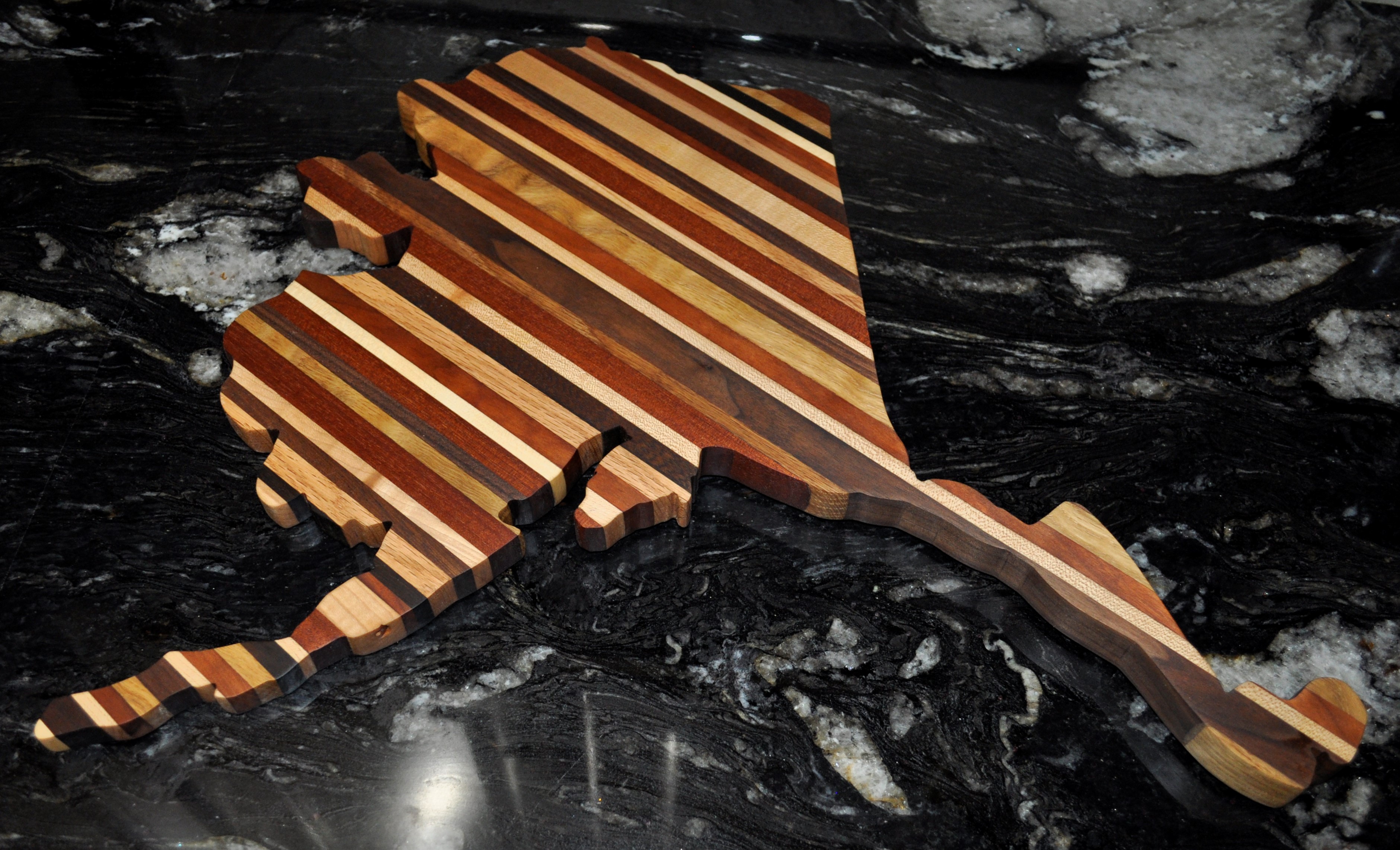
I find I have the greatest joy in woodworking when I am building a project specifically for someone. The hours spent communing with the wood are like hours spent focusing on that friend. With that in mind, every creation I make is unique, tailored to whoever will be the recipient. Every project has to start with an idea, and oftentimes it is the pieces of wood that tell me what they want to become, or the final project will have some symbolic significance for the recipient. The project example used in this blog post was made for a couple of friends who have worked in Alaska. It is a laminated wood cutting board that also denotes the fondness for charcuterie boards we had whilst we we coworkers.
I started this project by printing out a template to follow. I wanted to make a broad enough cutting surface to make the board actually practical, and the bulk of mainland Alaska provided a cutting surface of about 8″ by 10″. Due to the state’s geography, however, the Southeast Alaskan Panhandle and the Alaska Peninsula made this one of my largest and most complicated cutting board projects yet.

Cutting Board Template
The first step is to lay out all the strips of wood to be laminated together over the template. With a challenging shape like Alaska, it took some maneuvering to figure out how to make the board look good while also keeping it structurally sound. Since I wanted a varied look for visual interest instead of uniformity or pattern, I kept the widths of my wood strips at whatever size they happened to be; since my end goal was to have the cutting board be about 1″ thick, all the wood strips used started around 1 1/8″ to 1 1/4″ in thickness. A laminated cutting board is a great way to use up long, skinny scraps of hardwood, and cutting pieces to the size of the template helps further reduce wood waste. This cutting board is composed primarily of Oak, Walnut, Cherry, and Maple, laid out mindfully to highlight the contrasts in color and grain of each wood species.
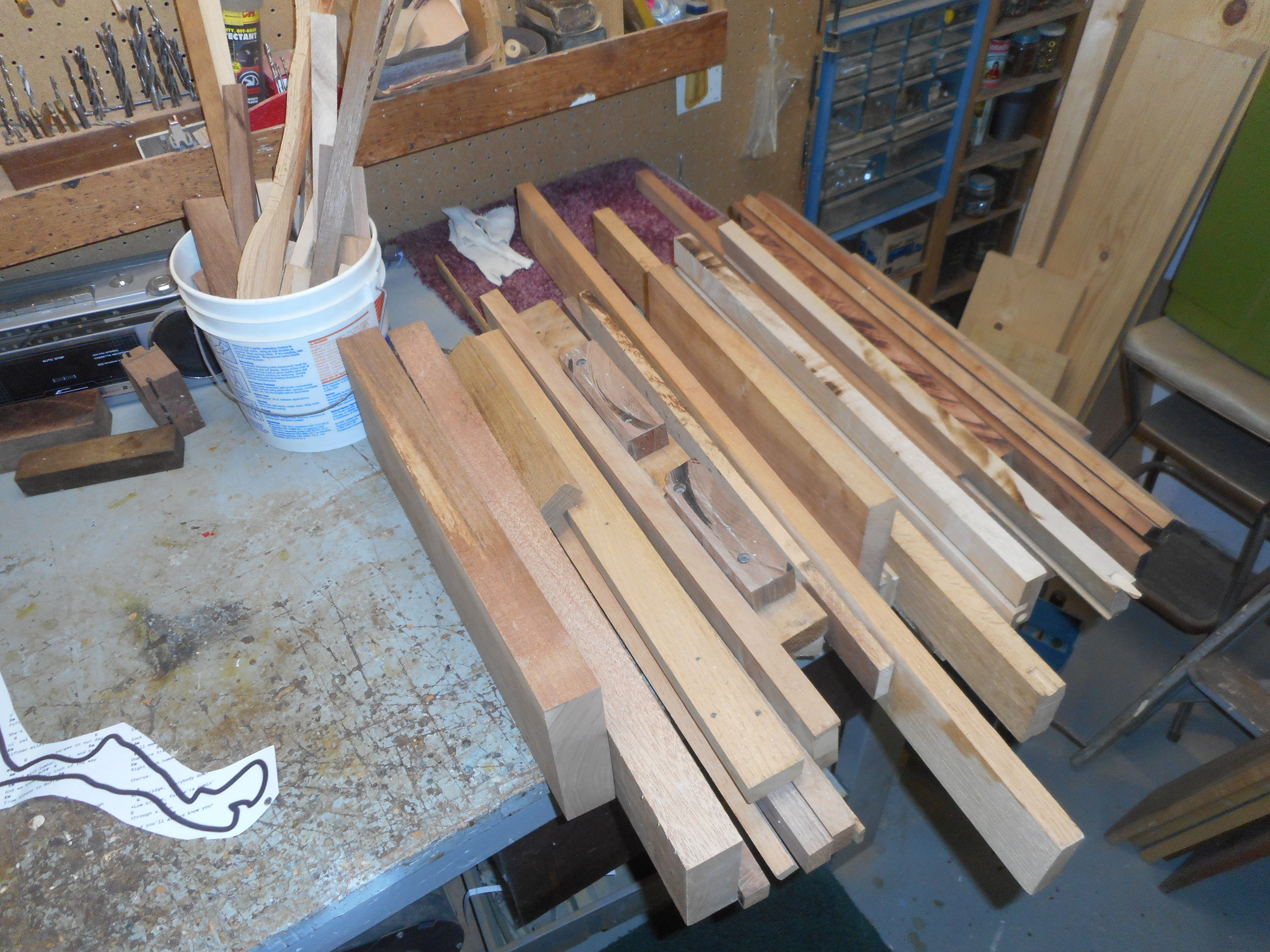
Some of the hardwood stock used to make the cutting board
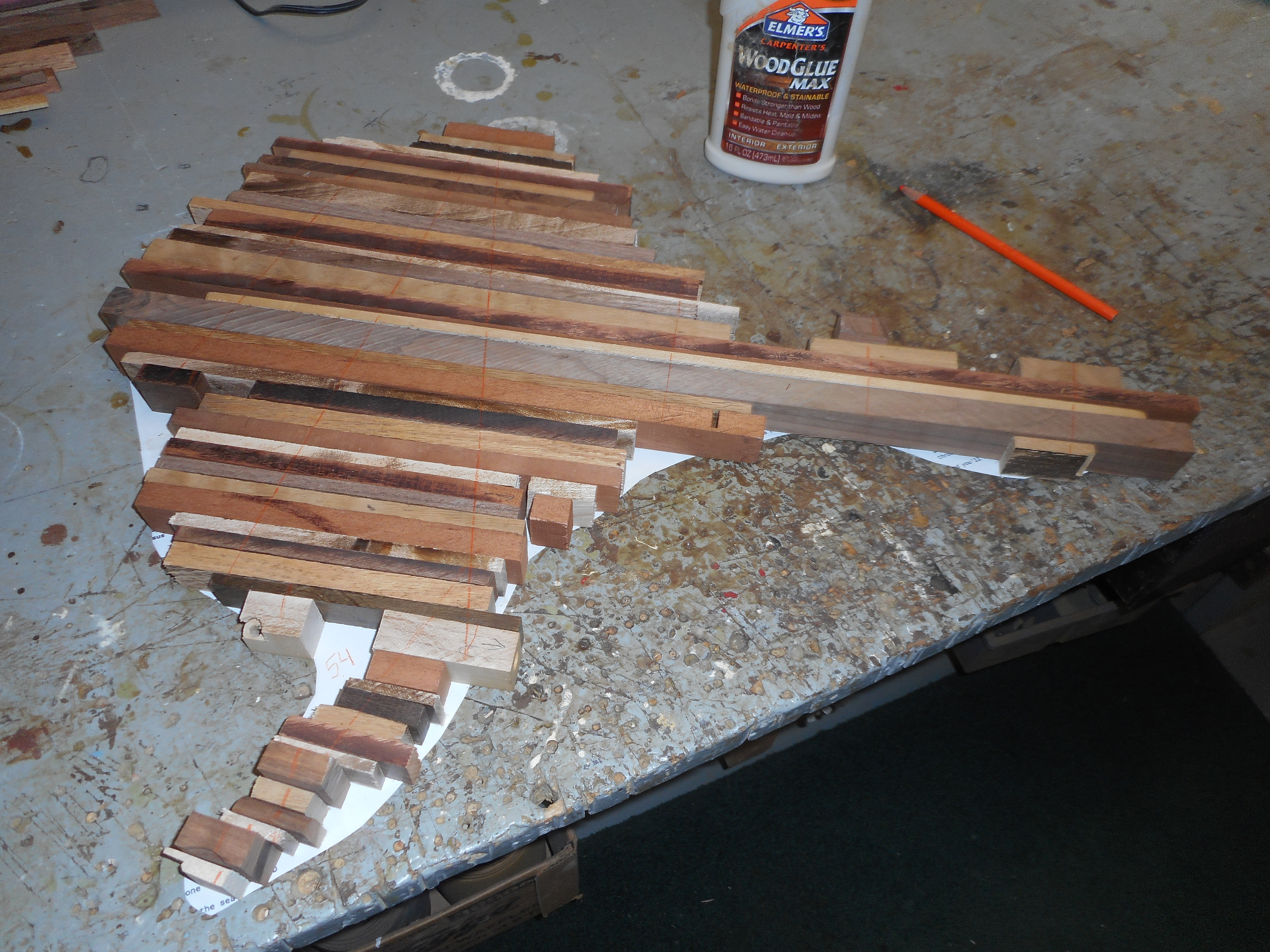
All the wood strips laid out and ready for glue!
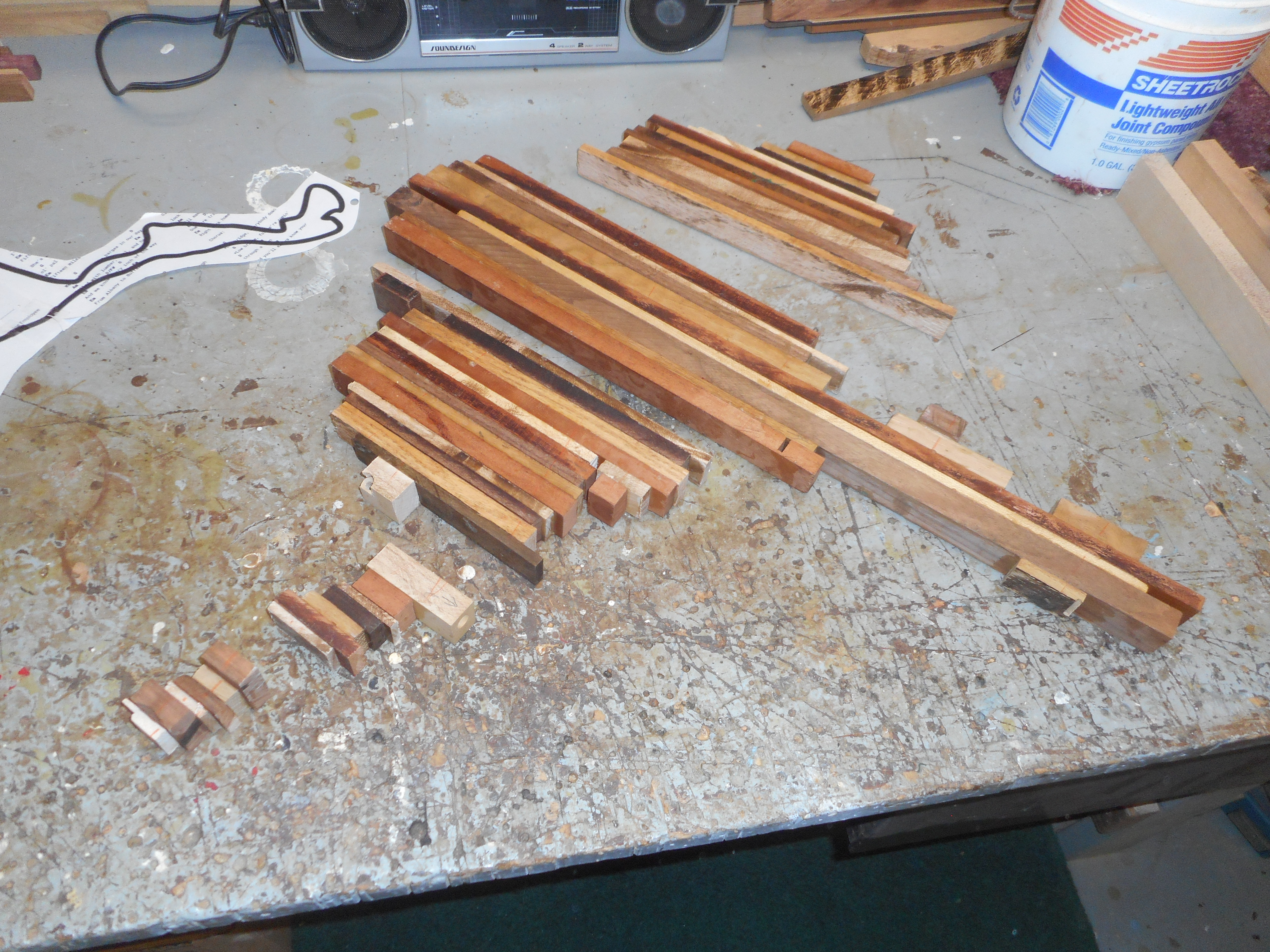
With all the wood strips laid out over the template, it is time to start gluing them together! I used a high-strength version of Elmer’s Wood Glue, just because the finished cutting board may get wet during washing. With so many different sized pieces, and with such an awkward shape to clamp, I segmented Alaska into five different sections to make square-ish shapes to promote more secure clamping. Another reason to glue in sections was that my planer had a six-inch width, which is very important in the next step. If I was using my high school woodshop, I wouldn’t have had that problem, and could have glued the entire board together initially as a unit.

The five sections, glued, clamped, and curing
Once the glue has dried, I simply ran the larger three sections through the planer until they were all approximately the same thickness. Planing works like quick magic in taking the uneven glue-slopped board sections and making them look more like a finished product. The two sections that composed the Alaska Peninsula were too small to fit through the planer, so I smoothed them out using a belt sander. Once the five sections were about the same thickness, I glued them together to complete the state of Alaska.
The five sections, glued, but before planing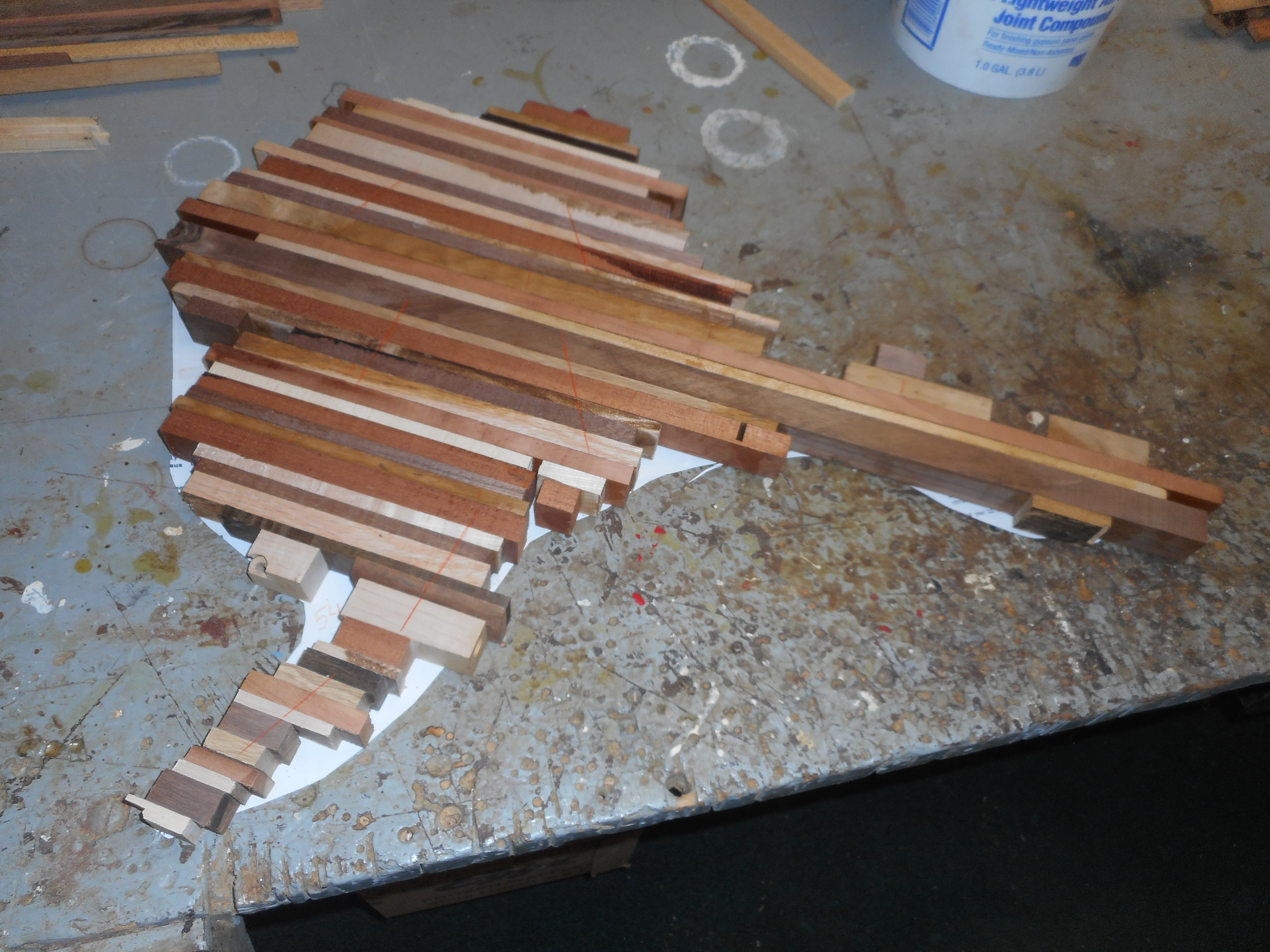 The five sections, planed and ready to be glued
The next step is a lot of work on the belt sander. While planing quickly gets wood down to the desired thickness, it leaves the wood pretty rough. The belt sander makes the surface nice and smooth, ready for an array of cheese and crackers.

Smooth results after the belt sander
Now for the fun part, one of the quickest transformations of the whole process! It’s time to lay the template back on the sanded board, and use a bandsaw to cut along the black line. And voila, the real Alaska emerges!


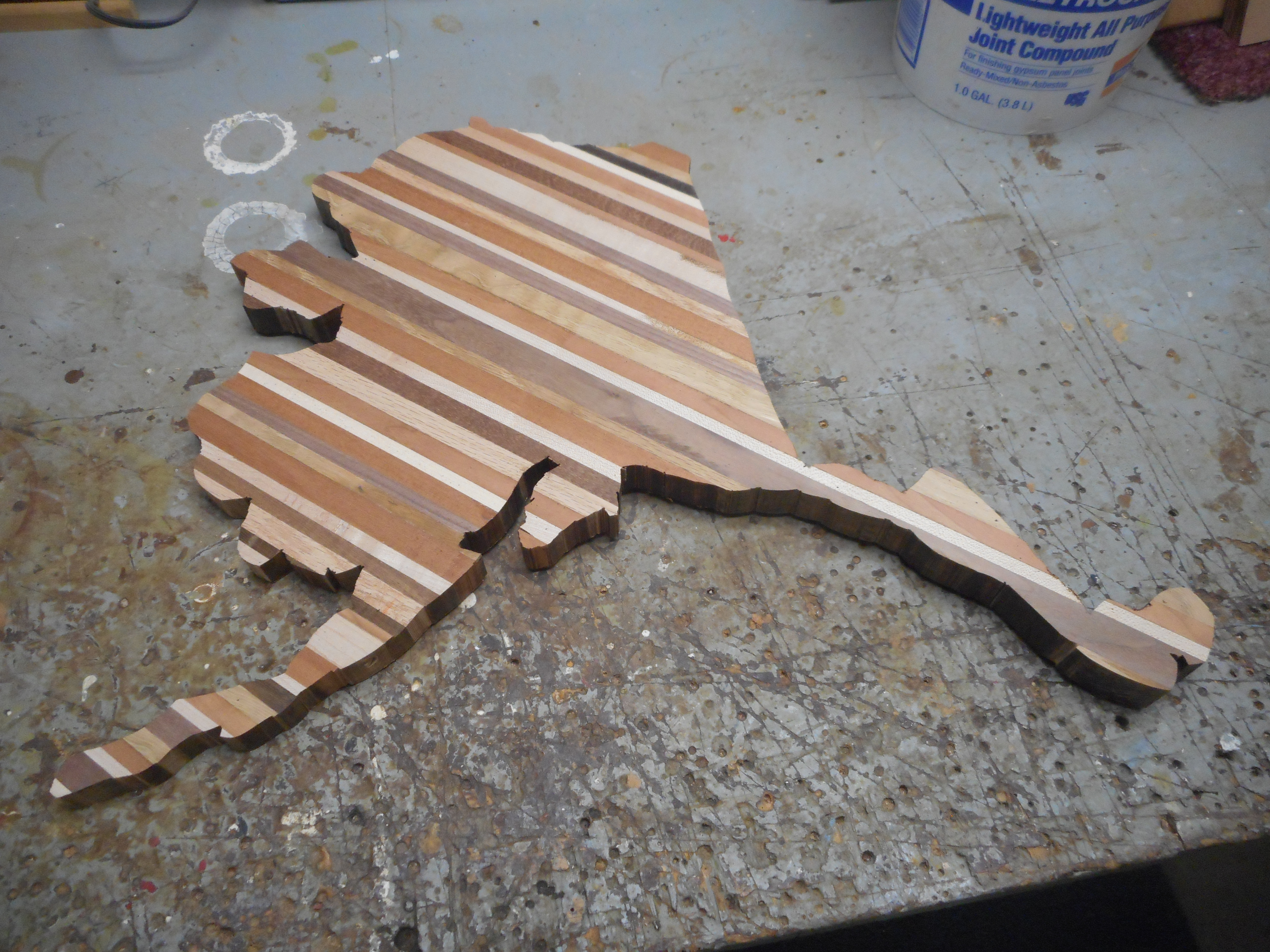
The big reveal!
With just some detailed sanding to smooth out the edges from the bandsaw cuts, the cutting board is just about finished. The last step is to protect the wood with a nice finish of food-safe oil. I hand rubbed in three coats of olive oil. Nothing like a good coat of oil to make the vibrancy of the wood really come to life!
The finished product
______________________________________________________________________________
To see more of my woodworking projects, follow the link to my website.

Coronavirus Can Collecting

Typical Roadside Litter
A pastime that I share with my father we both affectionately call ‘canning.’ Essentially, the process of canning means either taking a walk or cruising country roads by bicycle looking to collect returnable bottles and cans strewn along a roadside. The benefits of canning are two-fold in that it provides an incentive for outdoors exercise while it simultaneously cleans up the streets of litter. And, thanks to Michigan’s bottle bill, there is a financial incentive to canning as well, which puts a refundable 10-cent deposit on all beer and soda cans and bottles. Though ten cents for a single can may not seem like very much, over the course of an outing it does add up.
With concerns over transmission of the Coronavirus, Michigan’s Governor Gretchen Whitmer ordered all bottle redemption centers closed starting March 24. Automatic bottle returns were not mandated to reopen until June 15, after it was determined that recycling is not a primary driver of disease transmission (in fact, the most dangerous thing you can take into a grocery store during a pandemic is yourself). In the 82 days that Michigan bottle returns were closed, it was estimated that Michiganders collected over $80,000,000 in unredeemed bottle deposits, as the number of unredeemed containers grew by an estimated $7,000,000 each week. At ten cents a pop for a can, that means at one point Michiganders’ had over 800 million cans sitting in their basements and garages! The sheer number of containers alone is staggering, but as a grocery store employee it comes as no surprise as daily I see the overwhelming capacity of beer and soft drinks that are bought and continuously restocked.
Anticipating the impending closure of the bottle returns, I deposited my final pre-closure collection of cans on March 23, just in time for the shutdown. I redeemed a modest sum, a little over $20, which is typical for just a couple weeks of collecting. This meant that during the Coronavirus shutdown, my dad and I would have a fresh start for can collecting so we could visually see just how many cans would pile up on our collection outings during the closure. Even though most grocery store bottle returns had reopened by June 15, the vast number of unredeemed containers created a nightmarish bottle-return backlog. It was not until much later that I finally redeemed all the cans we had collected during the shutdown, mostly due to waiting out the Black Friday-esque rush to redeem cans in the weeks following reopening, coupled with a $25 daily limit on redemption slips. Not to mention that the sheer number of cans I collected would not have even fit in my car (unfortunately, I neglected to take even a single picture of the epic bounty!).

- Not my cans in particular, but you get the idea
It was not until July 8 that I had finally finished returning my three-ish huge garbage bags full of cans. That totals 107 days of collecting. Total value of redemption: $156.20. That equates to 1,562 cans and bottles total! (not to mention all the cans and bottles not redeemed for cash because they were either not acceptable brands or they were too mangled to be accepted by the machine. So this estimate will ultimately be on the low end!).
If we analyze this on a per day basis, this number comes out to nearly 15 cans per day! (14.6 cans to be precise).
Of course, my household did generate some of the cans in our collection. If we subtract our portion of the cans, with a simple estimate of 2 cans per household member per week (we don’t drink a lot of beer or pop), we end up with (15 weeks x 3 people x 2 cans/week/person) = 90 cans, or $9. Not a significant percentage of the bounty (6 percent).
So, excluding my household’s cans leaves 1,472 bottles and cans that were scattered by the roadside, strewn across parking lots, or generally improperly disposed of. In terms of the environment, this is 1,472 pieces of easily recyclable material that instead ended up as unwanted litter!
Michigan’s bottle bill, passed in 1976, put a ten-cent deposit on non-reusable beverage containers. Similar to other environmental legislation of the 1970’s, Michigan’s bottle bill was aimed at reducing trash pollution, conserving natural resources, and increasing the rate of recycling. Among the ten states that currently have bottle bills, Michigan has long had the highest deposit price (being joined only in 2018 after Oregon increased their deposit to ten cents as well). With that higher deposit comes the highest rate of container recapturing: prior to 2018, each year the bottle bill was implemented saw over 90% of beverage containers redeemed. It could be argued that the current trend of falling redemption rates is due to inflation decreasing the value of beverage container refunds; in 2020 dollars, the ten cents paid in 1976, the year the bill was enacted, would be worth about 45 cents today. Perhaps it is time to raise the required deposit to keep up with inflation.

- Scenes like these from the 1970’s inspired Michigan’s 1976 bottle bill
Though Michigan’s recycling rate has fallen slightly as of late, we still lead the nation in terms of container recycling. Unfortunately our national recycling rate is at a disappointing 34.5%, which lags behind many other developed countries. Other states have had trouble passing bottle bills of their own, even though they face substantial litter problems. Tennessee, for example, had bottle bills die in legislation in both 2009 and 2010, even though recycling rates in the state are an abysmal 10 percent and discarded bottles and cans make up the majority of roadside litter. Indeed, the Container Recycling Institute says that beverage containers account for between 40-60% of litter. More states might enact bottle return bills if it wasn’t for the powerful lobbying interests of the can and beverage manufacturers who spend hefty sums to fight such legislation.
So we’ve seen that the ten-cent container deposit in Michigan really does boost recycling rates. But what happens to the deposits on the containers that are never returned? Remember, Michiganders place deposits on approximately 70 million cans each week. Where do the deposits from the 10 percent of containers that are never returned go?
Unredeemed funds from bottle deposits are called escheat funds, and these monies revert to the state. Twenty-five percent of escheat funds go towards retailers to defray the costs of operating bottle redemption sites. The remaining 75 percent of escheat funds goes towards environmental protection measures, which include site-specific environmental clean-up (80%), educational programming on pollution prevention (10%), and deposits into the Cleanup and Redevelopment Trust Fund (10%). The Michigan bottle bill generates around six million dollars each year in escheat funds for the environment.
So every time that you purchase a bottle of beer in Michigan, maybe you should stop and appreciate that the ten cents tacked on to your receipt is helping Michigan’s environment. Not only has the bottle bill increased recycling and decreased litter, it also generates funding for environmental cleanup that is paid for (in large part) by people who litter. Though, as evidenced from the falling rate of container redemption in Michigan, and from my recent collection of 1,472 littered cans, there is still a lot of improvement to do. Michigan could further incentivize recycling by increasing the amount of the required bottle deposit. To combat the abundance of single-use plastic water bottles thrown away, Michigan could consider joining states like Connecticut, Hawaii, Maine, New York, and Oregon that require a deposit on bottled water containers. And another common roadside polluter is liquor bottles; liquor is not included in Michigan’s bottle bill, but liquor containers have a 15-cent deposit in the states of Maine and Vermont. Until society reaches a point where there is no more litter and we recycle purely because it is the right thing to do, my dad and I will continue to enjoy the 10-cent per bottle perk every time we go pick up litter off the roadside.
freshavacado

The Man Behind the Dairy Doors

I see you as you grocery shop.
I hear your conversations as you open the doors to my lair.
You may have seen a vague shadow lurking behind the milk before.
You may have even wondered what’s causing all of the creamer to suddenly slide forward on the shelf.
Maybe you’ve never thought much of those things. Maybe you’ve really never wondered what’s further past the meticulously displayed products behind those mysterious clear glass doors.
But sometimes there is a moment when all is revealed. Those rare, fleeting moments when, in the gap where the organic soy milk normally goes (but which is somehow inexplicably always out of stock), we make eye contact.
Yes, I am the man behind the doors. I am the one stocking the dairy cooler.
I will spend my whole shift in the quiet confines of this cold concrete bunker. Chilled to 40ºF, the pallets of milk, orange juice, and yogurt provide my company.
Each day in the dairy cooler is an intense game of whack-a-mole: stock the specialty milk products and non-dairy substitutes before any of the popular milk gallons or egg cartons run out. The work never ends. By the time I finish re-stocking the fat-free milk, I can look back at the whole milk and see just how many gallons have found their way into a customer’s hands already. Indeed, I can judge how busy foot traffic is on the sales floor based on how fast the milk disappears. A busy day, and I’ll have to restock the milk gallons twice in a shift. I can go through more than two pallets of a single variety in a day—and that’s 288 gallons per pallet.
I can tell when the store opens based on when the slams of the dairy doors begin. Like an impending thunderstorm, it starts with a few sporadic slams before the deluge of banging doors betrays the intensity of early morning shopper traffic.
In between door slams, I hear snippets of cell phone conversations, commentary about our current stock, and intense deliberation on which product to buy. I listen silently as I work to replace what is running low. Most of the chatter is not intended for me, though I hear more than you are aware of. Most of you don’t know I’m back here working—or that I’m quite amenable to help you with your dairy.
But some of you know the secret. There are the bold few who pop their heads in through the door, eye me through the gaps in the dairy, and ask me to find a product. Milk, I’m an expert in. Cheese and yogurt I know a bit about too. But please don’t ask me about dry goods. I am happy here in my dairy cave. I feel a bit like a hermit crab out of his shell when forced out onto the sales floor.
My job is to keep you happy and to give you dairy. You may never see me, but if the milk is well stocked then you know I’m there, always eavesdropping and spying on you behind the dairy doors.

Seeking Spring Ephemerals
Exploring Van Raalte Farm, a local Holland, Michigan Park
In early spring, well before the trees and shrubs send forth their leaves into the skies above, a fleeting class of plants emerges from the ground to live their brief, wonderous time in the unhindered spring sunlight. These flowers speckle the forest floor with patches of bright whites, yellows, purples, and reds, atop their brilliant fresh green foliage, in a welcome contrast to the subdued hues of winter. The ephemeral show lasts for a few short weeks before the flowers fade away and the lush greens of the plant wither away to wait the remainder of the year hidden secretly underground. In May 2020, I went off as a flower-hunter, spending time scouring a few local parks and preserves in the greater Holland, Michigan area, looking for native wildflowers. I found some ephemerals in bloom, was too late on others, but everywhere saw a diversity of early-blooming wildflowers. I encountered a much greater floral diversity than I could reasonably post here—so get out to your local parks and go seek your own wildflowers!


A sure sign of spring in the forest are the large brilliant blooms of the Trillium (Trillium grandiflorum) Melantiaceae. Single stalks with leaves of three and flowers with petals of three (it is the TRI-llium, after all). The showy white flowers gradually turn to pink.


A personal favorite of mine is the swaths of Trout Lilies (Erythronium americanum) Liliaceae that blanket the forest floor. Bright yellow lily-like flowers nod from a stalk that emerges above their one or two leaves. Brown mottling on the leaves is said to resemble the skin of trout, giving rise to the plant’s common name. Their peak bloom in West Michigan is in April, but I was fortunate to catch a few late flowers in May.


Forming dense clusters of large, deeply-cleft umbrella-like leaves is the Mayapple (Podophyllum peltatum) Berberidaceae. The fleshy stalks emerge in April, and a single white flower blooms in May. The ‘apple’ that gives the plant its common name (also called a ‘forest lemon’) does not ripen until June, and all green parts of the plant, including the unripe fruit, are poisonous.


Found abundantly in wet, marshy areas is the aptly-named Marsh Marigold (Caltha palustris) Ranunculaceae. This bright-yellow flowered plant grows in colonies and steadily blooms from April to August.


Another bright yellow flower, although this one with only a single bloom and being found in more upland the woods is the Hispid Buttercup (Ranunculus hispidus) Ranunculaceae. The word ‘hispid’ means covered with stiff hairs or bristles, and references the flowering stalk of the plant.


Dense colonies of 5-sepaled flowers growing up to one foot high in woodlands is an indicator of the False Meadow Rue (Isopyrum biternatum) Ranunculaceae. A true spring ephemeral, False Meadow Rue blooms for only a few weeks in May, then completely withers away to its roots.


Another flowering plant of moist woodlands, this one purple in color, is the Wild Geranium (Geranium maculatum) Geraniaceae. The geranium is popular with gardeners, and several domesticated varieties can be found in cultivation.


An incredibly brilliant and uniquely-shaped flower is found on the Wild Columbine (Aquilegea canadensis) Ranunculaceae. Several flowers, with five red-spurred petals and protruding yellow stamens, hang from the plant above its deeply lobed leaves. Nectar is stored in the flower’s spurs, providing food for pollinating hummingbirds.


Multiple globe-shaped clusters of tiny white flowers emerging from a single stem on the forest floor indicate Wild Sarsaparilla (Aralia nudicaulis) Araliaceae. Not far from the flowering stem are the leaves of plant, deeply divided into typically 5 leaflets. Young Wild Sarsaparilla with three leaflets and a glossy purple hue can sometimes uncannily resemble poison ivy. The roots can be used as a substitute for real Sarsaparilla flavoring, though the plant is not closely related to the True Sarsaparilla (Smilax sp.) of tropical climates.


A single palm leaf-like plant with a spiked cluster of small white flowers is the False Solomon’s Seal (Smilacina racemosa) Asparagaceae. It grows in the same habitat as the true Solomon’s Seal (Polygonatum sp.), which will have several bell-shaped flowers hanging under the stem. The origin of the common name ‘Solomon’s Seal’ is unclear, though it was perhaps named in reference to the plant roots resembling a signet ring or Hebrew characters.


Not only were the wildflowers blooming, but some trees were in bloom too. I came across this small native understory tree, the Eastern Redbud (Cercis canadensis) Fabaceae. The Redbud blooms profligately with bunches of pink flowers, making it no wonder it is popular as a landscape tree as well.

Showing promise of fruity treasure to come in June is this diminutive white flower, Wild Strawberry (Fragaria virginiana) Rosaceae. Wild strawberry plants sprawl across sunny open patches by spreading with runners. The thimble-sized strawberries are juicy and flavorful, and are quite popular with this flower-hunter.
The field guide I used in identifying these plants was Newcomb’s Wildflower Guide © 1977 by Little, Brown and Co.
Hi!

On Discerning a Pattern in the Music Played at the Meijer Supermarket
As the Coronavirus pandemic has upended nearly everyone’s lives from the old normal, I too have found my projected course of life disrupted. My planned employment for this spring—teaching environmental education and canoeing with schoolchildren in California—has been cancelled out of concern for spreading the virus. Fortunately, just as shoppers were starting to panic-buy toilet paper en masse and wiping supermarket shelves clean, I was able to snag a seasonal job at my local Meijer grocery store as a stockperson. Maybe it is due to my penchant for organization and my affinity for boxes, or maybe its my curiosity at how the modern food system works, but secretly deep down I had always been intrigued about working at a grocery store. Having done the job for a while now, I’ve found that stocking shelves of food product isn’t too complex, and the entire process can actually be quite meditative and satisfying at times (aside from the frequent waves of aggressive shoppers). So, with much of my mental capacity free to wander, and being in-store for 40 hours a week, I’ve turned my recent attention to more academic pursuits—that is, I’ve been trying to discern patterns in the background music being pumped-in through the intercom at Meijer.
It has long been known that music affects peoples’ moods. More recently, psychologists have undertaken studies to see how music affects behavior, particularly the behavior of customers in retail stores. For example, scientists have found that slower-paced music causes shoppers to move and browse more slowly, ultimately leading them to purchase more items. In contrast, faster-paced songs and songs that are familiar to the customer will cause shoppers to pick up their pace and spend less time in-store—items will be selected more quickly, but not as many items will be purchased. And what about streaming in some high-brow classical music? In contrast to pop music, playing classical in-store causes people to buy more expensive products. The amazing thing about this ambient background music is that shoppers often don’t draw it into their focused attention—the music enters the brain at the subconscious level and affects the shopper’s mood and spending behavior without their active awareness. Think about that the next time you’re getting groceries.
My conscious attention has been focused on the music played in Meijer, and having spent five weeks working there already, (which equates to about 200 hours of listening to their playlist), I’ve tried my best to discern any type of pattern or underlying psychological agenda I can pick out from their musical selection. The only conclusion I’ve come to is that the reassuring voice of Dr. Norman Beauchamp of Michigan State University, Executive Vice-President for Health Sciences, comes over the intercom on the hour, plus at 15-, 30-, and 45-past as well. In his most appropriately midwestern inflection ever, Dr, Beauchamp’s voice slips into our subconscious, reminding us to wash our hands often, and please, don’t touch your face.

In the words of Dr. Norman Beauchamp, “wash hands often, or use hand sanitizer”
Even though Dr. Beauchamp repeats himself often to drive home his message of public health, the songs at Meijer don’t, at least not in an eight-hour shift. Though I’m almost guaranteed to hear a certain set of songs each workday, the time of day each song gets played is still a daily surprise. There is no discernible song order, and some tunes are played frequently while others only on a rare occasion (when the exceedingly rare Brandi Carlile or Pearl Jam song comes on, I pause and think to myself, ‘hmm, this is quite atypical’). As to the customer behavior that corporate Meijer is trying to achieve with its musical selection, I am still baffled. the musical genres that are played seem to run the gamut. Here I’ll just give a brief survey with a few musical highlights of the sonic diversity experienced at Meijer.
The first few songs I actively noticed while working were because they were throwbacks to the summer of 2006, the year I turned sixteen and would sing out while driving by myself. Songs like Smash Mouth’s “Story of My Life” and Hoobastank’s “The Reason” have weathered the test of time a fair bit better, but Ashlee Simpsons’ “Invisible” and Saving Jane’s “Girl Next Door” have been left behind in the mid-2000’s, well, except at Meijer.
Of course Meijer would be remiss if they only played mid-2000’s pop without also playing some bad contemporary pop songs as well. Selections like “Perfect” by One Direction, “Tattoo (How ‘Bout You)” by In Real Life, “Love Yourself” by Justin Bieber, and “Hey Look Ma, I Made It” by Panic! At the Disco are the more recent earworms I unfortunately can’t get out of my head.
While the soundtrack at Meijer is primarily pop and light rock, R&B and Hip Hop get a little shake as well. Vanessa Hudgens sings “Come Back to Me” (talk about more mid-2000’s hits!) and Montell Jordan sings “This Is How We Do It” for a 90’s throwback.
And even Reggae fans aren’t even left out of the mix. Though infrequent, listen closely and you might hear a tune like Bob Marley’s “Could You Be Loved.”
Stores want customers to be in a happy, upbeat mood to increase consumer-spending. So it should be no surprise that Meijer pumps in upbeat feel good songs like Johnny Nash’s “I Can See Clearly Now,” and Billy Joel’s “The River of Dreams” every single day.
Does love cause people to buy things? Meijer must think so, judging by the vast amount of love songs they play in-store. They seem to particularly favor slow, sappy love ballads and duets, like A Great Big World and Christina Aguilera’s “Say Something,” Lady Gaga and Bradley Cooper’s “Shallow” or Landon Pigg’s “Falling In Love At A Coffee Shop.”
If slow love songs aren’t your thing, it won’t be too long before you’ll hear an 80’s synth pop ballad to pick up the mood and to make one reminisce about the days of hair bands. I am probably most intrigued as to why Dead or Alive’s “Brand New Lover” is on the playlist. Though upbeat and catchy, the lyrics do describe wanting to have an affair. Another song I still haven’t figured out what mood Meijer is trying for is Pet Shop Boys’ “West End Girls.”
In the mood for more 80’s? You’re in luck at Meijer. For an upbeat hit with an impossible number of key changes, try Sheena Easton’s “My Baby Takes the Morning Train.” I love this song every time, except when I’m just groggily starting work at 6am. Can’t get enough of key changes? You’ll eventually hear Michael Jackson’s “Man in the Mirror” too.
And if you get the impression that Meijer’s musical selection is only poppy and mainstream, just keep listening and you’ll hear an occasional song from the alternative music scene. Examples include Primitive Radio Gods’ “Standing Outside a Broken Phone Booth with Money in My Hand,” and a very quirky “Istanbul (Not Constantinople)” by They Might Be Giants.
It seems like the corporate music engineers at Meijer have me stumped. I can’t discern any subliminal messaging behind the song selection. Take a listen and see if you can find a pattern in this musical survey, and the next time you’re in a supermarket, stop and listen to the audio overhead.

A Royal Walk: Hiking across Isle Royale
The Sun Rises Over Isle Royale
It was the middle of May 2018 when I first landed on Isle Royale. That storied island—that mass of rock isolated in northern Lake Superior. So far away it seems logically like it should be part of Canada, yet it belonged to Michigan—the only National Park in my home state. The mystery of that island beckoned me from maps with its geography and isolation. Long had I wanted to discover what this coveted gem had in store.
At long last, I finally visited the island after spending a winter and a spring teaching environmental education in northern Minnesota. By that time, I had become quite familiar with the boreal northwoods from all those hours teaching kids in the wilds. The northern forests, hence, were not all that different from my everyday existence.
Given my years of anticipation, Isle Royale was bound to be something exceptionally different than what one could experience on the mainland, I believed.
As it was, my first trip to the island was a simple, short overnight stay, ferrying in from Grand Portage, Minnesota to the Windigo Visitors Center on the western end of the island. As far as landscapes go, the flat, forested, mixed-conifer forests of Windigo are not spectacularly different than the Minnesota Northwoods I had become accustomed to.
I was a bit underwhelmed.
I didn’t even bother to take any pictures (incidentally, my camera had broken earlier that trip).

Arriving at Washington Harbor at Windigo
I left Isle Royale that trip convinced that I had seen the island in the wrong way. A simple overnight trip was no way to do the island ecosystem justice. If I was ever to return to Isle Royale, I thought, I would do it in the right way: I would hike the island from end to end, slow enough to absorb the ecological transitions, to understand the essence of what makes the place, and to enjoy immersion in the vast isolation of Isle Royale.
As chance would have it, in the summer of 2019 I was selected to take part in a volunteer restoration crew on Isle Royale’s Rock of Ages Lighthouse. I would be returning to Isle Royale sooner than I had thought, and this time, I would be staying on to hike across the island afterwards.
The Rock of Ages Lighthouse
I started my hike on the western end of the Island, at Windigo, the widest part of the island. Here the forest commands the land and the coastline is smoother, less jagged. I made my way to the Greenstone Ridge trail, the hiking path that transects the middle of the island. Despite its name, the Greenstone Ridge at this point isn’t much of a ridge at all. The trail slowly climbs uphill under the cover of a mixed-forest—conifers, but also maples and even the warm-and-dry loving oaks. I spent my first night at the interior campsite of Island Mine, the site of an 1870’s copper mine that peaked and was abandoned in only a few years.

Broadleaf forests found more commonly on the western end of the island
Mining history would be a big theme of the hike, and copper was the resource of value. It wasn’t just white Euro-Americans who were mining the island either: the Ojibwe, the indigenous people of Isle Royale, had mined the island for thousands of years. Archeological evidence suggests that as early as 4500 years ago, indigenous people harvested copper by using stones to hammer off chunks of native copper from outcroppings in the bedrock. As their technology progressed, they began to mine deeper in the bedrock by building large fires over ore deposits, then quickly dousing the fire with water in order to crack the bedrock. Small indigenous mining pits can still be seen throughout Isle Royale today. By the 1840’s the Objibwe had been duped into ceding their lands to settlement and development for the resource-hungry Americans. Speculators flocked to the island to make their riches, but mining on Isle Royale was always boom or bust. Island Mine organized in 1874 and extracted over 200,000 pounds of refined copper. Three years later, the company went bust. All that remains now are scattered pieces of rusting equipment and mounds of tailings.


Day two saw me continue east along the Greenstone Ridge. After a few miles of hiking through the shady canopy, I began to get my first views from the ridge: small, rocky clearings at first with scrubby oaks and small shrubs partly obscuring the views. First the clearings were few and far between, but then they became more abundant. From the ridge one could begin to see some of the inland lakes that dot the island, including the scenic Lake Desor, near the summit of Mount Desor, which at 1,394 feet is the highest point on the island. From clearings further along I could even see Ryan Island in Siskiwit Lake, the largest island in the largest lake on the largest island in the largest lake.


With the gradual opening from shady forest to open ridge, another fun thing happened: berries. Up on the ridge, the sun beats down and the soil becomes dry. The seasons progress quicker than by the lakeshore where Lake Superior tempers the weather. Whereas the thimbleberries at lower elevations were still hard and green, up on the ridge I began to encounter a progression of ripeness: first, an isolated red berry, then a few on a bramble, and finally whole thickets of the bright red berries. Thimbleberries are a thornless, velvety cousin of the raspberry, with shallow bright red berries which are so soft and juicy that they can only survive the journey from the hand to the mouth.
After gorging myself on snacks of thimbleberries and taking a mid-afternoon swim in the cool and clear Lake Desor, I made my campsite at Hatchet Lake.
The clear summer weather finally took a turn for the wet on my second night. It was a constant heavy rain that slowly drenched me. I awoke (did I even sleep?) with about an inch of standing water in my tent. I later learned that at Windigo they recorded nearly two inches of rain in that overnight.
I would start my third day soggy. Today I would be leaving the Greenstone Ridge trail for the north shore of Isle Royale and the infamous Minong Ridge. I reached Lake Superior at Todd Harbor, a picturesque cove with a mélange of water-smoothed rocks. I took a short side hike to the former open pit of the Haystack Mine, and then followed a trail just a little bit further to find a small waterfall that was the cause of some bubbling noise off in the distance. From Todd Harbor I took the Minong Trail towards McCargoe Cove. The Minong Trail, though it never reaches as high elevations as the Greenstone Ridge, deserves its reputation as a knee-destroyer. The Minong Ridge is a series of exposed escarpement ridges: a rocky, uneven gradual climb up the bare basalt, followed by a steep dropoff on the backside. Then repeat, again and again. On a hot day, it wears you out, as it wears out your knees.


I reached the deep and slender McCargoe Cove by mid-afternoon, and after such a soggy night, I was eager to rest and dry out. This afternoon, I finally got a shelter at one of the island’s campsites. They are spacious lean-tos, screened-in, and with the perfect combination of both scenic views and isolation. I dried my clothes off and basked in the sun.


Though McCargoe Cove was my favorite campsite of the hike, there were not many people there at all. Isle Royale consistently is the least visited national park in the contiguous 48 states. In 2017, this National Park had only more visitors than Lake Clark, Kobuk Valley, and Gates of the Arctic National Parks, all sites in remote interior Alaska. With only 28,196 people even paying a visit in all of 2017, more people visit parks like Yellowstone in a single day than all of Isle Royale in an entire year. The great benefit of Isle Royale’s lack of popularity is its solitude. The trails and campgrounds never feel crowded. With fewer folks around, you also develop good connections with your fellow travelers quite readily. At McCargoe Cove, I spent the evening around the campfire chatting with our only neighbors: a group of fishermen from Chicago and a pair of ladies from the Twin Cities. Trail community seems to come easily here.

McCargoe Cove: Some Hike, Others Canoe
McCargoe Cove was also the harbor used for the Minong Mine, the most prolific mine in Isle Royale’s history. Like other island mine sites, indigenous people had harvested surface copper deposits here first. In 1872, modern mining operations had commenced at Minong. This mine produced some incredible finds, such as a 5,720 pound nugget of almost pure copper. Finds like this nugget, and several other massive nuggets, added fuel to the mining fire. Two shafts were dug, up to 300 feet deep, as well as several drift tunnels that followed the ore veins. As tunnels were dug, tailings, or waste rock, began to fill in the adjoining marsh that leads to McCargoe Cove. A boomtown known as Cove sprang up at Minong, housing upwards of 150 people at its peak. Along with its railroad, stamp mill, and blacksmith shop, Cove even boasted a post office. Indeed, the prospect of permanent settlement on Isle Royale seemed so promising that Isle Royale even became its own county in 1875. By 1885, however, all mining operations on Isle Royale came to a halt for good. The grade of the ore dwindled and the price of copper fell; Isle Royale proved to be too isolated and the winters too harsh. Eventually, even though over 4 million pounds of refined copper were removed from the island, all mining ventures proved too non-economical to continue. Island boomtowns were abandoned. By 1897, with no permanent population left, Isle Royale County was re-absorbed into Keweenaw County.


On my fourth day, after very much enjoying my single-night stay in the shelter, I was off to hiking again. This time I decided to traverse the island from north shore to south shore, hiking astride several interior lakes along the way. I had been told that these interior lakes were hotbeds for moose activity. As storied and prolific as the moose population on Isle Royale has been, I had yet to see my first moose on the island. I knew they’d be around, as I had already seen plenty of moose scat and browse sign.
The scenic and shapely-named Chickenbone Lake proved of no avail for moose, though it was a Mecca for giant dragonflies. The next lake over, at Lake Ritchie, I got my first far-off glimpse of a moose browsing in the aquatic vegetation far across the lake. With the gradual decline of the predatory wolf population, the numbers of moose on Isle Royale have skyrocketed in recent years, with an estimated 2,000 moose inhabiting just over 200 square miles of island (learn more about Isle Royale Wolf-Moose dynamics here). I would only end up seeing one other moose on my trip. After losing the hiking trail on some bedrock, I wound up following a moose trail into the woods. The moose trail petered away until I reached a swamp. Suddenly, a large startled moose crashed away from me through the brush!
Though I had seen two moose, as far as their illustrious predator the wolves went, I had yet to see any. When I had visited previously in 2018, there was just a pair of wolves left on the island, simultaneously a brother-sister pair and a father-daughter pair (you do the math on that inbreeding!). In the winter of 2018-2019, four more wolves were introduced to reinvigorate the existing wolf population. For anyone, seeing a wolf is a rare treat. Alas, I never had a wolf encounter on the island; the closest I got to seeing the wolves was the island cabin of well-known wolf-moose researcher Rolf Peterson.

Moose researcher Dr. Rolf Peterson’s Rock Harbor cabin
Once at the south side of the island, I camped at the large harbor of Moskey Basin. Completely different from the small, sparsely-filled campgrounds I had been staying at, Moskey Basin was filled to capacity with both families and large groups, and its vast expanses of exposed bedrock and its picnic tables made this site feel luxurious and tame. But I should have expected that, visiting in high season after all. Even in high season, though, Isle Royale is not that busy, and getting all of that wilderness ambiance while hiking was a treat not to be taken for granted.
The cove at Moskey Basin was a sight to behold—layers of exposed bedrock outcroppings running right into the water. I hadn’t noticed it too much before, but the island was becoming rockier and rockier the further I traveled east. The exposed rocks left plenty of good places for sunbathing and also proved to be a prime habitat for blueberries (thimbleberries, unfortunately, had all but disappeared after leaving the Greenstone Ridge). Also without my noticing, the broadleaf tree canopy had disappeared too. Thin soils could no longer support the large broadleaf trees seen more westerly on the island. Instead, the forest was becoming more a stunted array of firs and spruces.


With a clear night ahead looking promising, I made a commitment to staying up to see the stars. This being mid-summer in the westernmost Eastern Time Zone, the sun did not set until near 10pm, and the stars did not emerge until well afterwards. After a full day of hiking, I was usually in my tent well before the stars came out in their full glory. But I stayed up tonight and was treated to a show on an absolutely moonless night. Being miles away from any human settlements, the stars on Isle Royale are absolutely amazing!


My last day on Isle Royale would take me into the primary tourist outpost at Rock Harbor. Rather than hugging the shoreline trail to my final destination, I once again went inland to take the Greenstone Ridge home. The trail up to the Mount Ojibway Fire Tower was never too steep, provided uninterrupted views, and proved to be premiere blueberry habitat. The whole climb up I had a constant handful of blueberries as a power snack. The Mount Ojibway Fire Tower, unlike its much squatter kin at Mount Ishpeming, actually provides visitor access to the base. Climbing the tower provides views of the entire island from north to south.


The Greenstone Ridge continued its path northeast across exposed rocky and grassy balds. By the time I reached the Mount Franklin lookout, it was clear I was encountering a different area. The overlook was populated with day-tourists hiking up from their various Rock Harbor lodgings. I left the viewpoint and went on the downhill to Rock Harbor and my hike’s end. At the eastern end of the island, Isle Royale’s tilted geology splits the island into many narrow peninsulas and long bays running towards the northeast. I walked along these deep harbors right along the trails by the edge of Superior’s turquoise waters.
A sign for campsites signaled that I had made it into Rock Harbor. I could now bask in the luxuries of this tourist depot. Modern settlement at Rock Harbor started with a few unsuccessful mining ventures in the 1840’s, then moved into the realm of commercial fishing, as Scandinavian immigrants built their fishing shanties after the copper booms. By the early 1900’s, these fishermen were guiding pleasure-seekers around the island and accommodating throngs of tourists in cabins. Several resorts eventually popped up, having their heyday in the 1920’s. The Great Depression and changing societal tastes caused a drastic decline to tourism in the 1930’s. By 1940, Isle Royale had been declared a National Park, and the National Park Service began the process of buying out and shutting down the remaining tourist resorts and removing fishermen from the island. Gradually, this formerly logged, mined, and settled island would be transformed into a 99% wilderness park with no permanent population.
Today Rock Harbor boasts a store where one can buy fresh vegetables as well as craft beer, hot showers ($6 for a five-minute shower), laundry, a restaurant, rustic cabins, and even a few hotel rooms. For this wilderness traveler, it was a world apart from the Isle Royale I had just experienced. The development at Rock Harbor was a foil to the isolation of the island. Though I milled about the Rock Harbor Village for a while, it just wasn’t what I needed. I made off to a quiet edge of Lake Superior and took a long, cleansing swim in her waters. For me, that is what Isle Royale is about.

Rock Harbor Lighthouse

A Week on the Rock: Restoration Volunteer at the Rock of Ages Lighthouse
Vintage image of the Rock of Ages Lighthouse (image from Rock of Ages Lighthouse Preservation Society)
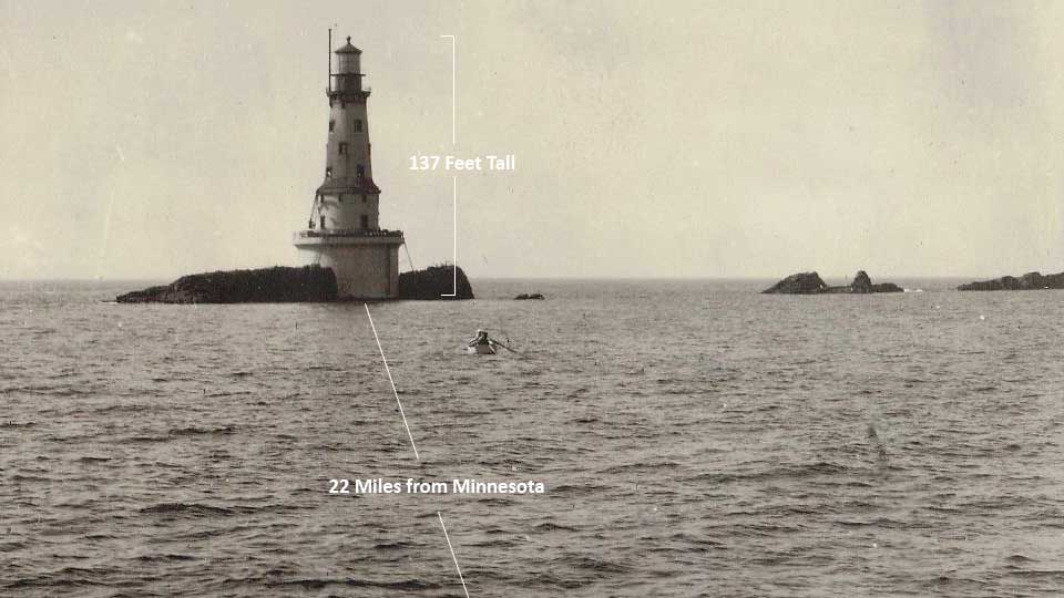
Northwestern Lake Superior, May 27, 1933, 6pm—The passenger steamer George M. Cox plies briskly through the frigid waters at full steam ahead, despite a heavy fog having settled over Lake Superior. On her maiden voyage after an elegant and expensive refit financed by New Orleans businessman George Cox, the Cox is bound for Port Arthur, Ontario carrying a load of 127 prominent guests, passengers, and crew. The captain and owner of the Cox need her to make good time on this voyage in order to impress her passengers and to show the Cox’s viability against other steamer lines in the lucrative vacation travel business. In the heavy fog enveloping the lake, Captain Johnson and First Mate Kronk can hear the fog signal from the Rock of Ages Lighthouse—they know they are near Isle Royale, but continue onward at 17 knots. Suddenly—a jarring jolt and the sound of scrapping metal. The George M. Cox runs full speed into the Rock of Ages Shoal, lifting 110 feet of her bow out of the water and giving her a dangerous list to port. The command to abandon ship is immediate.

The wreck of the George M. Cox (image from Ampers)
On watch from the Rock of Ages Lighthouse, head keeper John Soldenski hears the crash and lowers the rescue boat to race off to the scene of the wreck. Though the wreck of the Cox was spectacular, there were no major injuries and Soldenski is able to tow all the life rafts safely to the lighthouse. At this cylindrical lighthouse on an isolated rock outcropping no bigger than 50 by 200 feet, all 127 passengers and crew onboard the Cox would spend a bitter and cramped night. The rescued crammed into the spiral stairwells of the Rock of Ages, or alternatively took turns huddled against the cold on the rock itself to avoid the overcrowding. The next day, rescue ships removed all George M. Cox passengers and crew with minimal injuries sustained and no loss of life in the wreck and subsequent rescue. As for the Cox herself, insurance declared her a total loss and she sat beached on the reef for months. She became a tourist attraction in her own right, and local Isle Royale fishermen brave enough to enter found many luxury goods to plunder. October storms later that year broke the Cox in two, and she slipped quietly to the depths of Lake Superior.
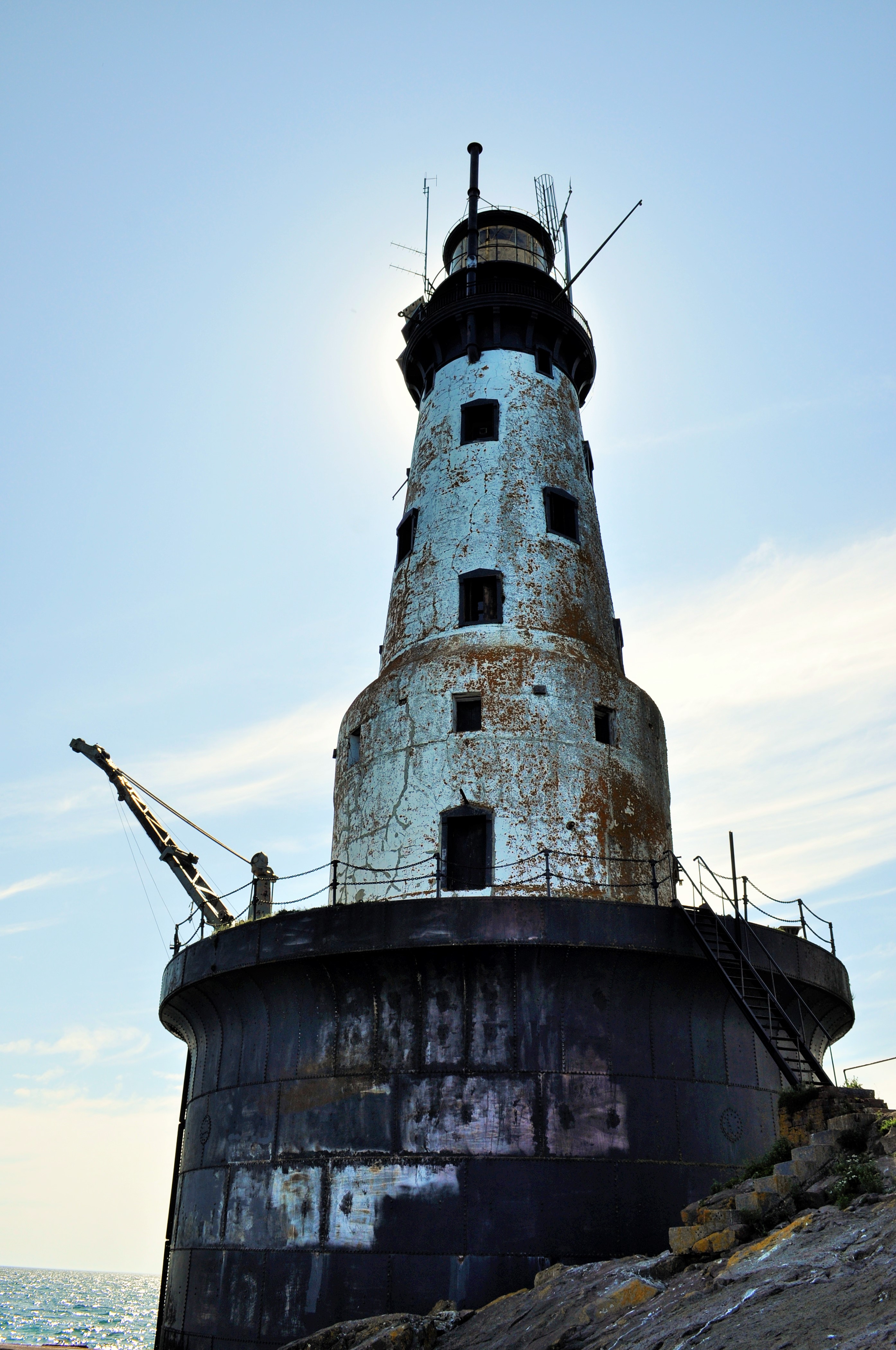
Despite this history of heroism and lore of rescue on the high seas, technological advancements and automation eventually led to the end of the keeper era at Rock of Ages. In 1978, the light was automated and the final keepers said their goodbyes. The lighthouse itself was prepped for its abandonment—windows were filled in with cinder blocks, doors and fixtures were removed, and all the interiors were coated with semi-gloss white paint—even the remaining light bulbs. In 1985, Rock of Ages’ magnificent 2nd order Fresnel lens—a lens that allowed a flame to shine for 29 miles—was removed and replaced with a much smaller solar-powered lantern. The door to the lighthouse was locked. The magnificent beacon that is the Rock of Ages was left to weather the elements alone.
But such an iconic and storied lighthouse could not be left alone to weather away indefinitely. A group of citizens, concerned with the fate of the Rock of Ages Lighthouse, formed the Rock of Ages Lighthouse Preservation society with the mission of restoring the lighthouse to its 1930’s appearance and to opening up the light to public visitation. Restoration work has been undertaken on the light since 2014. In July of 2019, I was able to join in these restoration efforts for a week of volunteer service at the Rock of Ages itself.
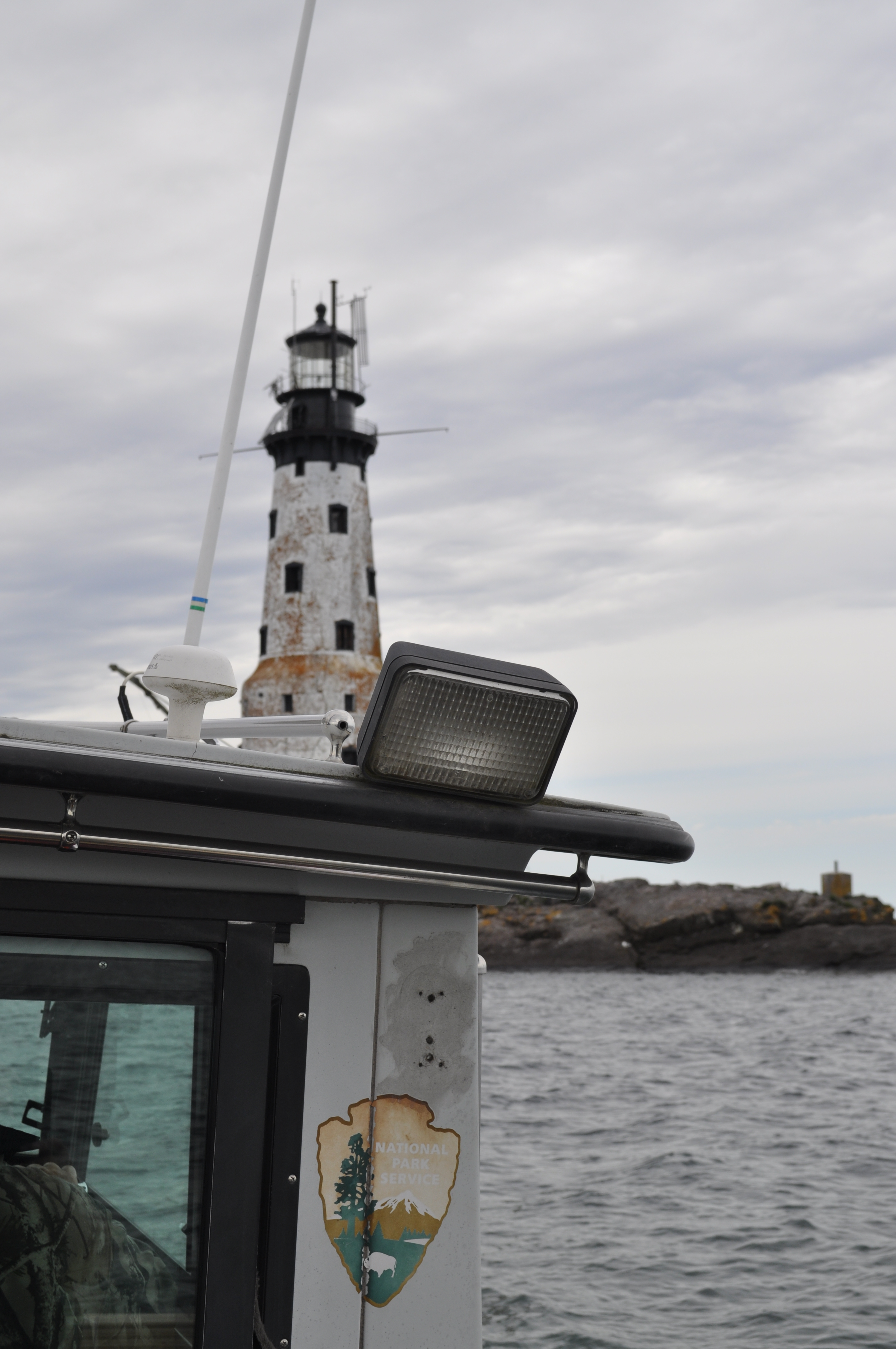
Getting dropped off for the week
The crew was led by two-time lighthouse volunteers, the Nebraska couple Josh and Heather: odd-job experts, and woodcraft miracle workers. Joining them were me and Dakota Dirk, a professional historical restoration carpenter from Minnesota and an avid collector of antique oddities. For five nights, we stayed at the Rock of Ages itself. Our project goal for the week was to finish installing the 3rd floor hardwood flooring and to install window, door, and baseboard trim on the 3rd floor galley and the 4th floor keepers’ quarters. I would be staying in the unfinished 5th floor assistant keepers’ quarters.


The Rock of Ages Lighthouse is located more than 20 miles off the North Shore of Minnesota, and another five miles southwest of the Windigo Visitors Center on Isle Royale National Park. Upon arriving at Windigo on our first day in service, we immediately took a smaller, former NPS patrol craft to the shoal on which the Rock of Ages sits. Seeing as how Lake Superior is rough and unpredictable, and how the lake has claimed many larger ships throughout the years, the length of our stay would be determined by when the weather was favorable to access the light. It is a situation still the same as the keepers of old; during the active years, the keepers’ tours of duty would be subject to the mercy of Lake Superior. Keepers could often be stranded for days or weeks until weather would allow a ship to remove them at the end of the season. One crew of keepers was down to a single can of tomatoes for provisions when they were finally removed from the lighthouse. Hopefully our restoration crew would not suffer the same fate; we packed plenty of extra peanut butter just in case.
At the dock on the Rock of Ages
Our first day on the Rock of Ages was spent exploring the place that would serve as our home base for the next five days. The rocky reef on which the Rock of Ages sits is a jagged piece of basalt that emerges from nowhere and drops precipitously off into the azure waters of Lake Superior. No wonder this place posed such an immanent threat to shipping traffic. The Rock of Ages Light was built to mitigate the hazards of this reef. Construction began in 1908, when workers blasted a 50-foot diameter hole in the rock down to water level, in which the foundation of the lighthouse would be laid. The first two levels of the lighthouse, encased in steel and concrete, were finished in 1908 and served as storage areas for the Light. Being at water level, these two levels were constantly battered by waves and exhibit a characteristic clammy dampness. The remaining eight levels of the Light were completed in 1909. The main floor of the lighthouse was the third level up, and contained the engine room. From there, the spiral staircase leads past the 2nd floor lounge and office, 3rd floor galley and mess hall, 4th and 5th floor keepers’ quarters, 6th floor watchroom, 7th floor service room, and finally the 8th floor lens room. A journey up the lighthouse’s 149 steps will take one past various unrestored levels with peeling paint and blocked-off windows, as well as a few freshly finished and yellow-hued rooms. From the panoramic views of the lens room, 117 feet up, one can look out on Lake Superior and see the buoys that mark the wreck of the ill-fated Cox, along with the 1877 wreck of the Cumberland and the 1898 wreck of the Henry Chisholm.


Our volunteer work focused on installing flooring and trim work in the 3rd and 4th floors. Restoration crews in prior weeks and years had previously demoed and painted these levels in order to make them habitable for work crews staying out at the lighthouse. Our job was to wrap things up by installing the finish trim. This was no simple task, as all our trim pieces were straight, and the entirety of the lighthouse is circular (not to mention that water damage and exposure had rotted out much of the underlying structural wood we were nailing into). Using a variety of construction techniques, some woodbending, lots of trial and error, and perhaps some voodoo magic, we as a crew were able to finish most of the trimwork on these floors. Adding the trimwork really tied the rooms together. And being period appropriate too, all the trimwork was a fancy compilation of early 1900’s-style solid oak. Despite being such an isolated lighthouse, the keepers at Rock of Ages were blessed with quite ornate woodwork.


Even though the restoration crew put in long hours on the restoration project, there was still plenty of time to enjoy spending at the lighthouse itself. With so much restoration work actively going on, the lighthouse was a great place to play architecture sleuth. One of my favorite down-time activities was roaming the floors of the lighthouse trying to piece together its history—its construction, its changes, and its restoration. Hanging out in the lens room was the best location to feel the immensity of Rock of Ages’ isolation. To the east is a view of the entirety of Isle Royale; to the north is Minnesota’s North Shore and the Sleeping Giant of Ontario; to the south the endless expanse of Lake Superior. My favorite spots to watch the sunset were in the lens room and on the 7th floor catwalk. With favorable weather most of the week, we were always treated to spectacular sunsets and to watching seagulls fly in the wind.


Blow Ye Winds!
Despite the lighthouse’s isolation, we had several visitors stop by throughout the week. Maintenance workers from NOAA stopped by to maintain weather equipment, and the National Park Service had groups of protection and maintenance rangers stop by. Our daily break was also timed around 2:20, when the Sea Hunter III would pass by with day-trippers to Isle Royale who all took pictures and waved.


")
Our friends also included the many seagulls who called the Rock of Ages home. Their calls intermingled with the wind to provide the constant background music of Rock of Ages. In high winds, from the lens room, we would watch as the seagulls had a heyday soaring in the breeze. There were also several fledgling seagulls born on the Rock that we watched in anticipation, waiting for their first flights down to the water.


Our other constant friends were the midge flies. Every object outside the lighthouse was coated thickly with a layer of midge flies and other insects taking shelter from the constant wind. On the few occasions that the Lake Superior winds ceased to blow, the midges would take flight, forming an airborne swarm. I, as well as everyone else, inhaled too many midges to count.


At last, it came time to leave the Rock of Ages. The final two days of our volunteer period had thunderstorms in the forecast; we would need to leave the reef while we had a good weather window. Though I find it disappointing that we never experienced the extreme weather that the old-time keepers had experienced (with waves crashing up to at least the 6th floor ), it was a spectacular week on the Rock nonetheless.


")
If you are interested in learning more about the Rock of Ages Lighthouse restoration project, volunteering, or donating to the cause, please visit the Rock of Ages Lighthouse Preservation Society website.

Aboard the Good Sloop Clearwater
After serving four months aboard the Hudson River Sloop Clearwater, it is incredibly difficult to summarize the experience in any amount of words. I served as a crew member as the good sloop plied the Hudson River from the post-industrial valley town of Kingston to the bustling shores of Manhattan and Brooklyn. Along the way we sailed past historic bridges and lighthouses spread out over ninety river miles of the scenic Hudson River Valley. We enjoyed rain and rainbows, sunsets worthy of a Hudson River School painting, and city lights off in the distance of many unique Hudson Valley towns. The crew busied ourselves with teaching fourth graders all about their river ecosystem on schooldays, and with entertaining guests on chartered sails on evenings and weekends. Our crew played music together, played games together, slogged through the rain together, and all made sure that this 50 year-old replica of a historic cargo vessel sailed safely from dock to dock and would keep sailing for 50 more years. Mere photos of the ship can never do justice to the myriad of tasks that are involved in operating a historic tall ship, or to the vibrancy of the community aboard the vessel. But as my tribute, here is a photo montage of the fine and splendid sloop Clearwater that has served as my workplace, my home, and my community for the spring and summer of 2019.
")


")

")


")
")
")

Geographical Oddities
For those of you interested in some of the irregularities of state political boundaries—for instance, why Michigan is separated into two large peninsulas, why Oklahoma has a panhandle, or why Colorado is just a boring old rectangle—there is a great book to read. That book is How the States Got Their Shape by Mark Stein. In detail, Stein explores each state’s border—explaining the various social and political forces, many oft-long forgotten, that went into the making of each state’s boundary. It’s an easy and entertaining read, and it is quite surprising to learn how often petty disputes (i.e. Missouri’s southeast corner) or rudimentary surveying mistakes (i.e. the Kentucky/Tennessee border) made America’s state geography much more complicated than it ideally should have been.
For some folks, it is simple enough just to read about peculiar political boundaries. For others, it is necessary to visit them (think about the 4-corner intersection of Colorado, Utah, Arizona, and New Mexico, which is a modern-day tourist attraction. The allure of being in four states at once is well worth the three dollar entrance fee!)

The Utah, Colorado, New Mexico, Arizona 4-corner border. Yes, I’ve been there.
And, as American political boundaries rarely follow logical physical geographical boundaries, the result is some absurdities in state physical geography extremes. Recently, I spent a weekend exploring some geographical oddities near me; in particular I went to Mount Frissell, a mountain in Massachusetts which oddly enough is also the highest point in Connecticut.
What drew me to this particular non-descript mountain in the extreme southwestern corner of Massachusetts? Well, it was a form of geographical tourism known as highpointing. Simply put, highpointers are people who try to reach the highest point in each state or region. Now personally, I had previously climbed the tallest mountain in a few states before, but I had never really made highpointing more of a goal until I picked up a guidebook of state highpoints at a library used book sale last year. Being somewhat of a geography nerd, I thought it would be a fun travel project to undertake (at least to all the highpoints in which ropes and glacier travel are not required!)
And hence I learned about Mount Frissell. Though the mountain has its own scenic merits and was quite a lush walk through the deciduous Connecticut uplands, I would have had incredibly little reason to ever visit otherwise.

Mount Frissell
My approach to Mount Frissell came from the Connecticut side of the mountain, where an inconspicuous town road out of Salisbury eventually leads to the trailhead destination. I drove northwards out of town, up a narrow dirt road lined with verdant shrubs and trees. Immediately after hitting the state border marker with Massachusetts, I was at the trailhead. Oddly enough, I would not enter Connecticut on this trip again until I emerged at its state highpoint!
The trail to the summit begins deceptively flat and effortless. A quarter mile in, though, as East Coast trails are prone to do, the path shoots straight up the bedrock slopes of Mount Frissell. Fortunately, the trail was short enough, the views rewarding, and in less than an hour I was at the summit of Mount Frissell, elevation 2,454 feet.
Though I was at the summit, I still had not accomplished my highpoint goal for the day (nor was I at the highpoint of Massachusetts. That honor belongs to Mount Greylock at 3,489 feet, just a couple hours’ drive north.) Fortunately, my climbing portion was done. All I needed to do now was to descend about 300 yards down Frissell’s south slope until I reached the Connecticut border.
A rock cairn and a humble state survey marker are the only evidence that you’ve made it to Connecticut’s highpoint, a modest 2,379 feet. The area itself looks little different from the surrounding forest, and, being on a slope, the views are fairly obscured by vegetation. Nevertheless, I enjoyed being the highest person in the state of Connecticut for awhile, as I rested and perused the trail register notes left by fellow highpointers.
For geography bonus points, continue walking west on the trail for a few more minutes. Soon you will come upon the tri-state boundary for Massachusetts, Connecticut, and New York. As you stand there deep in the woods, maybe you’ll wonder to yourself ‘why in the world did people bother to put this giant stone obelisk in the middle of the forest?’ Well, that’s geographers for you.

The New York, Connecticut, and Massachusetts Tri-State Boundary
Other nearby state superlatives of note: Bash Bish Falls, measuring nearly 200 feet in a series of separate cascades, is Massachusetts’s highest waterfall. Well worth the visit.

Bash Bish Falls, Massachusetts’s Highest Waterfall
